Group flights, Aussie style. Aussie Group Flights Team is the ultimate way to explore the world with your favourite people.

 RED CENTRE EXPLORER 2026 — BRIEFING CARD
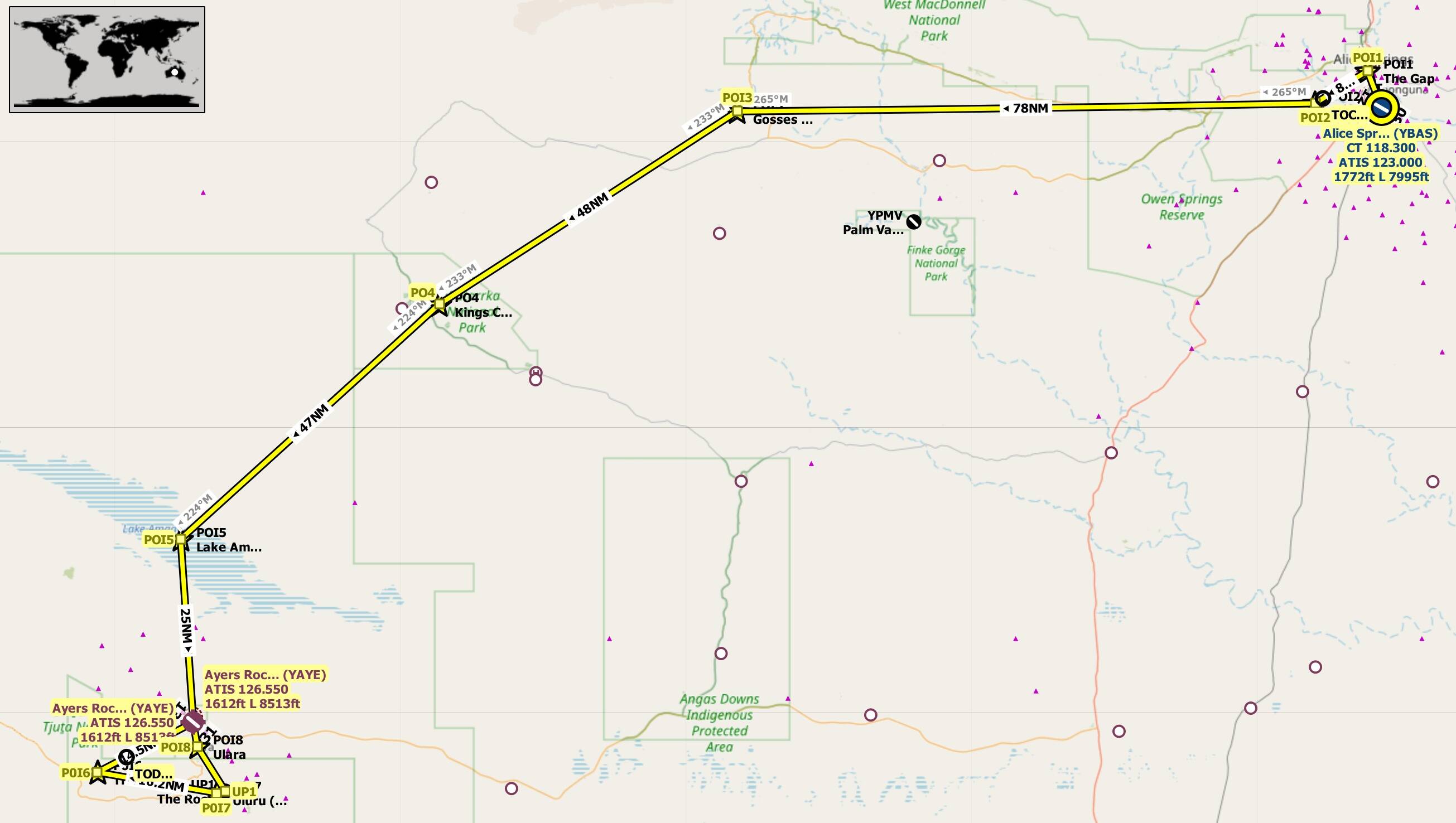
Alice Springs (YBAS) → Kings Canyon → Ayers Rock (YAYE) → Uluru → The Olgas → Return to YAYE
Central Australia Scenic Heli Series
 AIRCRAFT
Airbus H145 HEMS • Bell 412 • AW139
Altitude 1,500–2,500 ft AGL | VFR | Daylight Ops
Total Distance ≈ 246 NM | Duration ~ 2 h 10 m + 15 min break
 ROUTE FLOW
| Leg | Segment | Distance (NM) | Remarks |
|---|---|---|---|
| 1 | YBAS → The Gap → Pine Gap → Gosses Bluff | 91 | Scenic climb over MacDonnell Ranges and meteor crater fly‑over |
| 2 | Gosses Bluff → Kings Canyon | 48 | Canyon hover and 15‑min break at rim helipad |
| 3 | Kings Canyon → Lake Amadeus → YAYE (Ayers Rock) | 72 | Desert transition, salt‑lake reflections, full‑stop landing |
| 4 | YAYE → Uluru → The Olgas → YAYE | 35 | Scenic circuit around Uluru and Kata Tjuta formations |
 SCENIC HIGHLIGHTS
-
MacDonnell Ranges ridge lines and spinifex plains
-
Gosses Bluff meteor crater impact site
-
Kings Canyon rim hover and landing
-
Lake Amadeus salt flats mirror effect
-
Uluru and Kata Tjuta golden‑hour circuit
 EVENT NOTES
-
Recommended departure: 0900 local for cooler air and clear visibility
-
Maintain terrain awareness in canyon hover phase
-
Expect light turbulence near Olgas ridge line
-
Badge awarded: Red Centre Explorer Pilot
 EVENT AWARD
Red Centre Explorer Pilot
Brass and red‑sand finish with RFDS cross emblem
Presented to pilots completing all legs and station stop without refuelling
If you are not a member, to join for FREE, click here: Aussie Group Flights Team - On-line Flying
Details to follow. Hope you can join us.
PLEASE NOTE: THIS INFORMATION IS FOR FLIGHT SIMULATION USE ONLY.
Regards, Paul