Here is the Bing data, same location, same zoom level but a major difference in quality.
1 Like
@Shack952514 Good screenshots and photo comparison. That’s exactly my point and why I started this topic here. Your images of the Dolomites and also the Matterhorn summerize it pretty well: Mountain terrain in FS2020 is quite a joke and disappointement.
I agree that the sim all in all is great, but the lack of believable correct mountain terrain kills it for me in thouse areas. Especially when not even the height is correct!
Everything looks way to smooth and flat and… well… just not even close to the real thing often.
I really hope the developers are listening and will fix this.
Because like I said right in my first post: Highquality 3D data of these areas exist! In Switzerland, they could get it from Swisstopo… and in other countries there are scources too for sure.
If the 3D terrain on Google earth on my 4 year old iPhone looks better and more accurate, we have a problem ^^
So guys, please write Asobo via Zendesk like I did. The more people mention this, the better.
We want mountains. Not hills. ![]()
8 Likes
oooooh they look fantastic, my favorite! Look to XP11 and will be disapointed. Here in FS they looks cool, really. Also I did some days ago round trip in Himalayas around Everest max to 20000ft on 1013 Hpa from Lukla and Makalu was extremly fascinating, flying on it’s West face was unbelieveble, then I feel as I’m little…
1 Like
While I cannot share your enthusiasm about the places I posted above, I agree that Makalu and the surrounding area looks quite nice, at least compared to the Matterhorn.
Since in the old official Alpha screenshot below Makalu looked rather different, I assume that the elevation data for this region has been updated. This gives me hope that other regions will be updated as well.
Yes,
that first picture looks like from SE heading. Nice…
Update: aaah forget to say that Eiger and Jungfrau (also Monch as junction) are perfect…
I would not say Eiger Mönch and Jungfrau are perfect… more like “okeyish”, at least from the distance.
They are definitelly not as horrible as the Matterhorn or the Dolomites. Thouse are just a joke.
Like many rocky areas in generall.
In the end it’s super simple: They just have to ad better, more detailed terrain meshes. Let’s hope they will do that.
5 Likes
Just a question : are these pictures taken on ultra quality ? The setting « terrain level of detail » must make a difference. I personnally didn’t try to change it.
Good to know:

Well, how to integrate your generated mountain into the simulator?
EDIT: I give it a try with that tutorial but sadly, it looks the same as in the simulator ![]() I guess the problem is the heightdata, the simulation only uses this and the result…we all know that. There must be a other way to import a decent 3d model of this mountain
I guess the problem is the heightdata, the simulation only uses this and the result…we all know that. There must be a other way to import a decent 3d model of this mountain ![]()
1 Like
Yes, all was set to ultra.
1 Like
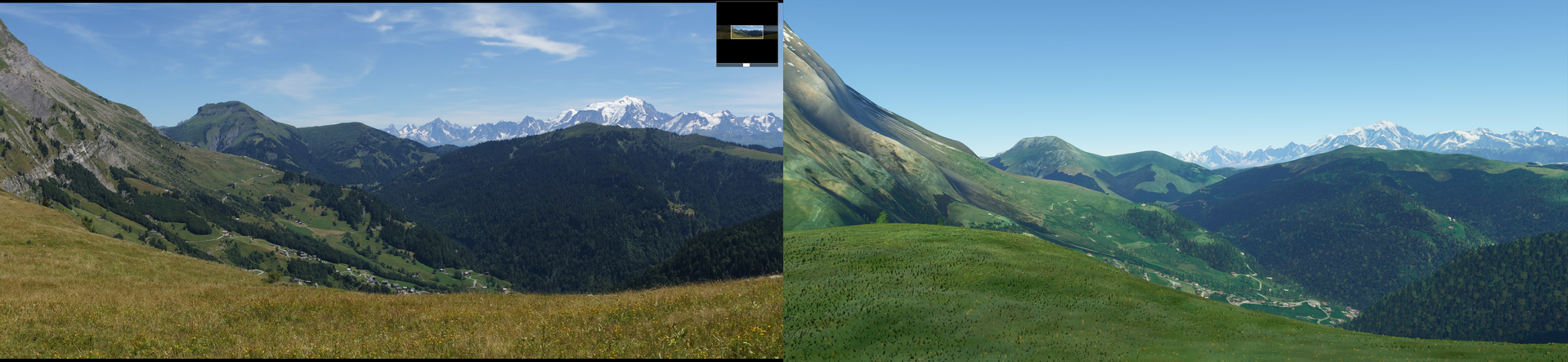
Near LFHM, “col des Aravis”.
I can agree that the mountains lack a bit of sharpness, but the result is still great.
The difference with the Swiss mountains is noticeable, maybe Switzerland lacks of precision in the mesh ?
3 Likes
Well I’m not talking about the detail level when you are 100km away from a mountain… ![]()
I’m talking about when you are flying close over a mountain.
Look at the images Shack952514 posted above, for example of San Vito di Cadore, Dolomintes, Italy.
The top 1/3 of the mountains basically is not there at all.
Wild, rocky steep mountains have been smoothed to death and look nothing like the real thing. Same goes for many other areas.
It’s not at all just Switzerland.
I just know Switzerland very well and that’s why realize the lack of detail much better than in other areas.
I can only repeat myself: They simply use very poor terrain data and I really hope they fix it.
Google has about 100x better terrain data in Google Earth. So why can’t Microsoft with Bing?
1 Like
I was not trying to defend the rendering of the previous screenshots. I agree that the Dolomites and the Matterhorn are terrible.
It’s just that my flights in the French alps weren’t as disapointing. I based my comparison on my personnal pictures (it’s easier when you know exactly were it’s taken from). I’ll try to find a better exemple, closer to peaks.
My feeling is that the rendering is not uniform : some places seem better than others. At least I never met mountains as erased in France : the top altitudes seem correct, and the global shape respected.
Maybe elevation data sources are not the same : it has always been easy to find an accurate open source mesh for France, that I used in FSX. Let’s hope for improvement in Switzerland & Italy.
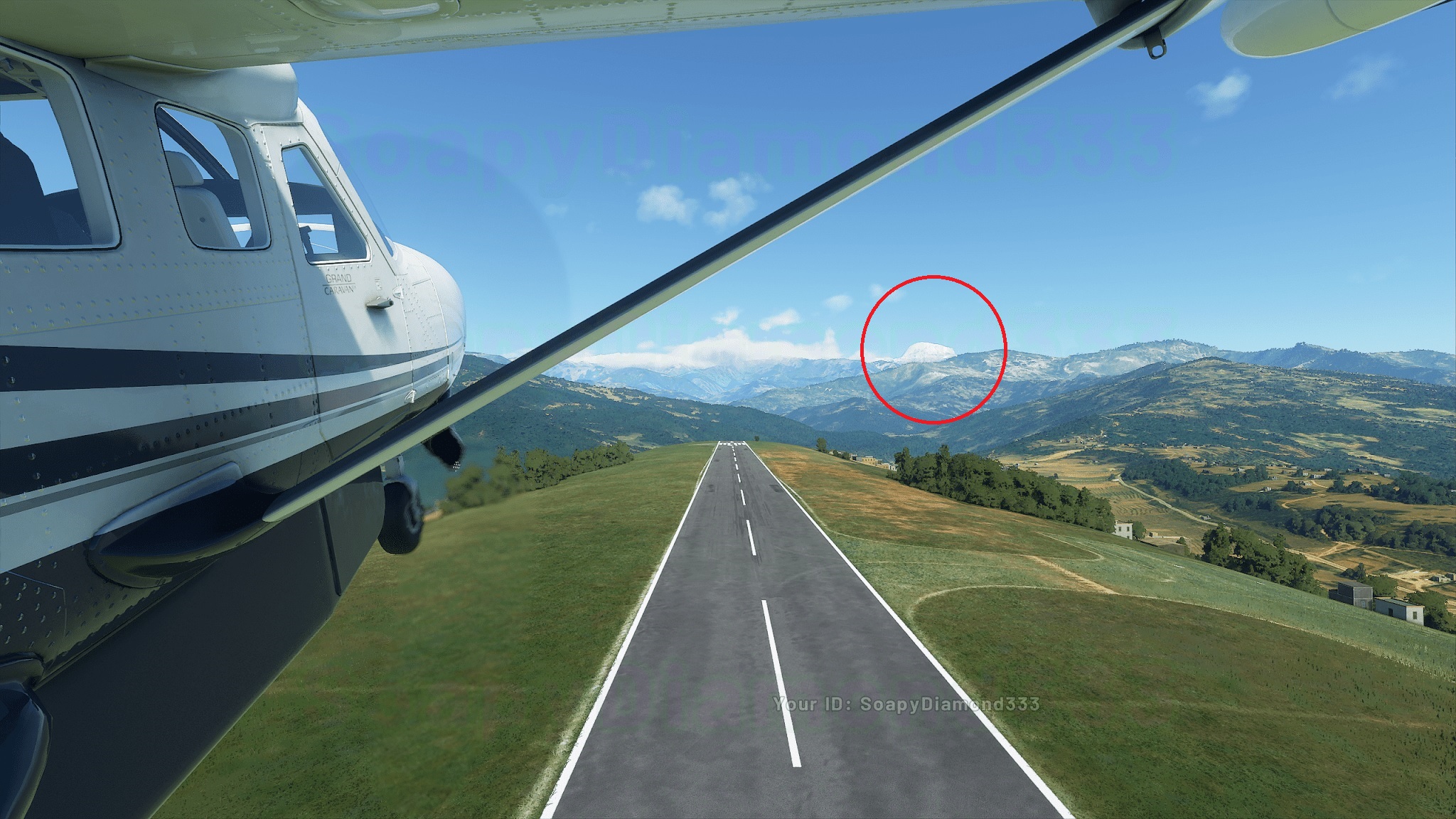
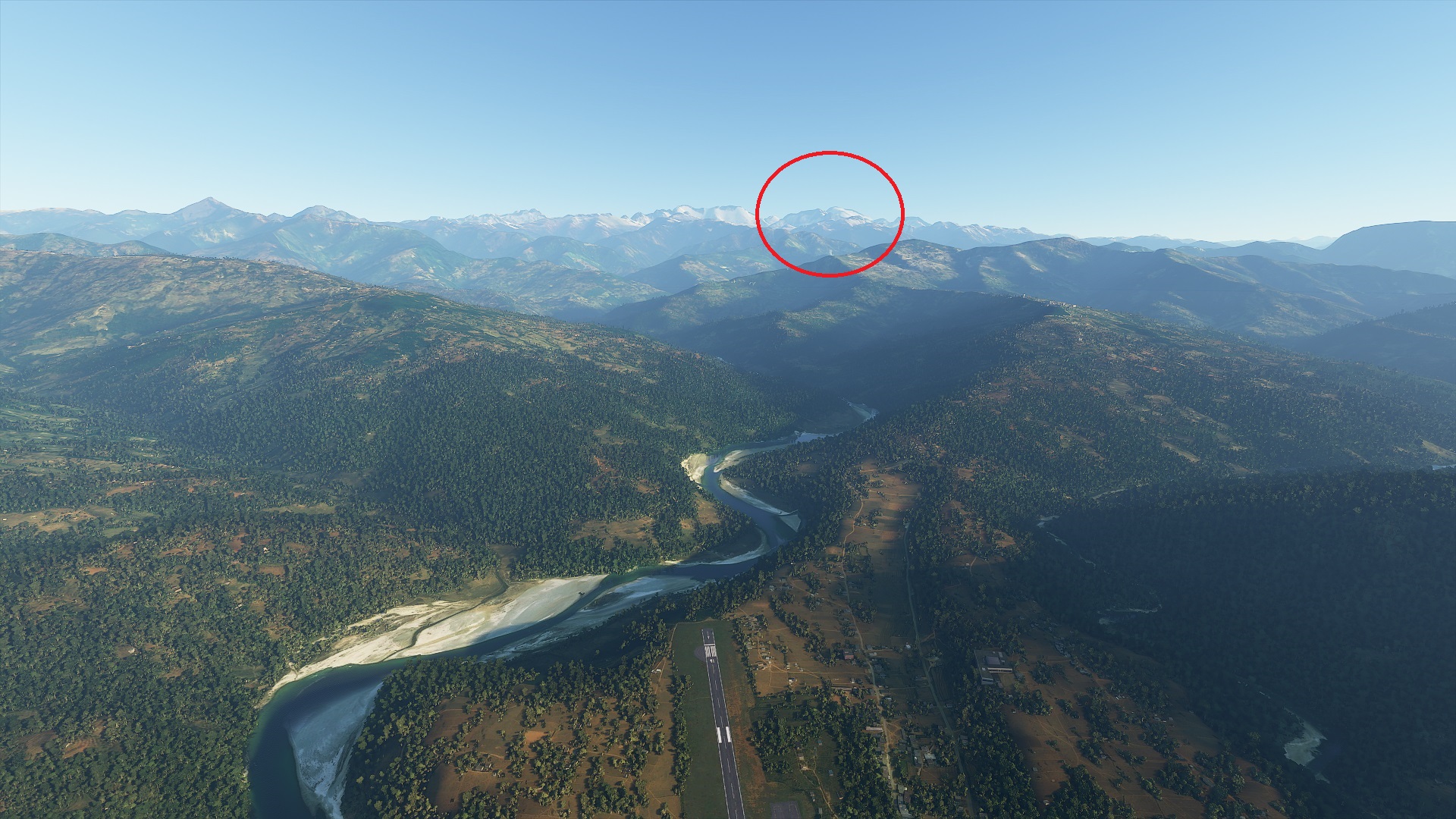
Here are some examples from the Himalayas around VNPK. The iconic mountains are basically non-existent in MSFS 2020 compared to X-plane 11 with Ortho4XP. I hope this gets fixed.

25 Likes
Ouch!
That looks terrible.
2 Likes
Do you think, they can fix this in the future ??
@MagicalScarab89 thank you for posting these images. That’s EXACTLY what I mean.
Mountains in FS2020 are just a desaster.
It’s not a question of if they will or can fix it. They have to.
The current state is a bad joke.
4 Likes
Yep, I just flew around the Annapurna. This mountain seems so easy to climb ! ![]()
1 Like
Also we need flatten roads, the roads across mountains looks terrible, for example Alpe d’huez road, in French Alps.
2 Likes
Totally agree about the roads. But first we need actual mountains ![]()
3 Likes