#worlddowngrade III 
im 50, so no spring chicken ![]()
you are right… ![]() i take it back… just flew over Tokyo… lots of photogrammetry and it looks WAAAAAAY better than London, the sim also performs way smoother too. so what on earth happened with London
i take it back… just flew over Tokyo… lots of photogrammetry and it looks WAAAAAAY better than London, the sim also performs way smoother too. so what on earth happened with London ![]()
At a guess I would say it’s down to the quality of the PG. Some areas of London, at street level, have some really wonky looking structure to them. I would surmise that these additional structures have lead to more detail, and all those additional surfaces have to be rendered. Think of a sphere. Easy to render. Now instead of a sphere with a flat surface, render it as a grill, and the grill having a 3D model. That leads to more polygons to render, more surface detail, and more cost.
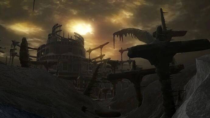
These kind of spiky, blasted bits of London’s streets are everywhere. I don’t know how efficiently these are culled from view when higher up, though.
London performs nothing like it did before the UK update, and disabling PG takes it back to where it was before the update, even with PG on.
even when i disable PG, London still not performing as well as pre update in VR… not to happy about that. AND i had the Orbx pack then !
Now ASOBO have done the ‘eye candy’, can they now concentrate on regional airfield tower traffic control?
Yes, and I would imagine the artists/teams involved with those POI’s, improved DEM, and imaging data will get right on the ATC implementation, just as soon as they have also fixed the turboprop logic, and the missing features of the G1000 et al.
@ hobanagerik
dunno about all that, i struggle to fly me little Cessna 152 around and land it safely …dont know about DEM etc… but having fun 
Gotcha by almost 30, but if you’d like to learn more and also view a bunch of classic warbirds from Viet Nam, you might take a quick look at my blog “danangafb.blogspot.com”. Just in 2D, though… 
It’s not so much the small wonky buildings that are the problem. More like the huge amount of unnecessary geometry used to render large spiky buildings when they’re actually very regular.
All photogrammetry is like this as raw data but there’s huge scope for optimising it. Unfortunately if there’s no way to do it automatically, the manual method is incredibly time consuming and therefore expensive.
I agree, and that was why I compared it to the end level of Dark Souls.
All those spikes, and other structures, have a lot of detail in their geometry, and that comes at a cost.
yeah, crazy stuff, had a look… very interesting tho ![]()
Your missing so much, honest.
You can do a lot automatically. It shouldn’t be too hard to identify cranes sticking out, trace them them and cull them out. As well as identify floating bits not attached to anything, delete. Algorithms can identify and simplify buildings, turning them more into a box instead of a irregular surface.
However, perhaps they already tried that and you end up with uneven looking detail. All the noise in the data also creates the illusion of more detail than there is. If you have ‘optimized’ buildings in between the lower level / surrounding more noisy data, it will stand out like the handcrafted buildings do now, except with less detail and more bland textures.
It could use a much better LOD reduction though, spiky buildings in the distance should not happen. With meta data the game can figure out where the buildings are and make sure to reduce these into boxes instead of pyramids. It will get better over time, it’s all still very new.
Keep it up, guys! You might convert me, yet!!

yeah, its all to easy to let your ego run away with itself on forums, all a bit silly really … ![]()
The older i get, the more i see age is just a number, the person inside is still the same, never really changing…bit wiser maybe, a bit less concerned about what others think of you, but essentially… the same.
Don’t forget that if you go that way, you are forever stuck with repeating that curation every time there is an update in that area.
Think of Google maps. The “satellite” view and “street” view is often months, if not years, out of date. And any effort to automate it means you’re going to have color, season, new construction, and other errors creep in.
Photogrammetry is created by planes flying at different angles and Google cars capturing street level data. That geometry is then textured from the aerial images, like a sheet draped over a chair.
As the saying goes, “Garbage In Garbage Out” – meaning the scenery is only as good as currency and accuracy of the detailed terrain map, and the currency and accuracy of the texture map draped over it.
I’m in! And almost blind  I should buy a Vr headset and then blame it all to the bad resolution.
The graveyard level. When you see it you’re almost dead 
