VFR-VOR in Greece - GROUP CLASS
Multiplayer Event - VFR-VOR in Greece - GROUP CLASS
Date / Time May 28th, 2022 - 02:00 PM CDT /// 1900Z /// 19:00 GMT
Sim: Microsoft Flight Simulator
Server: EAST USA
Departure ICAO: LGMG
Arrival ICAO: LGKZ
Aircraft Recommendation: Cessna 172
Target Speed: 110 KTS
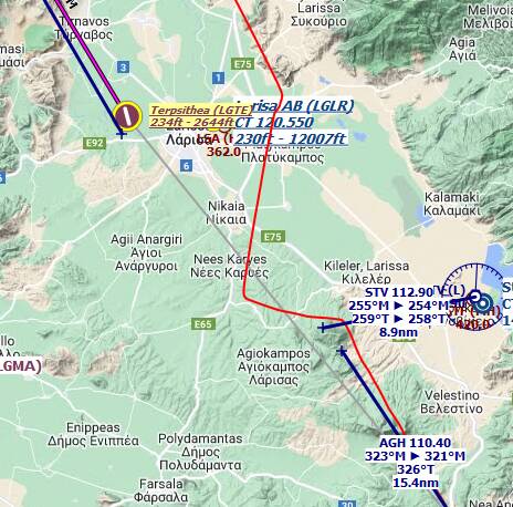
Route: LGMG → LGTH → LGSK → LGBL → LGTE → LGKZ
Flight Conditions
MULTIPLAYER: ALL PLAYERS
AIR TRAFFIC: OFF
WEATHER & TIME: Daylight, good visibility, no wind. The rest is up to you!
About the event
Not your typical Group Flight.
Actually, it doesn’t even register as a “group flight” this time, but as a group flight lesson. No magenta line to follow. No “PLN” file to load in your sim. We will explore some areas in Greece following (some, not all) VFR rules and radio navigation techniques.
And if you’ve never used this, don’t be scared, that’s exactly the purpose of this lesson: teaching the principles of VOR navigation. But still in a very humbly way, as I’m not a real pilot.
So today, no flight plan, but a PNG or PDF to download and follow while we fly. It’s a table that says from where we start, and for each leg, what heading to follow, until what “precise” point in the word. VOR will be here mostly as a measurement tool that will give us confidence about where we are and if we’re really well aligned with each waypoint.
We won’t use any navmap/GPS/whatever. Just our eyes and basic instruments.
The rest of this text is pretty long. It will be as follows:
- I’ll describe the technical (software) solutions to allow you to check this flight table while flying.
- Then it will be some illustrated theory to VOR navigation and how to set up your frequencies/radials in various types of planes.
- We’ll continue with the usual recommended free add-ons (nothing crazy today)
- And finish with the actual flight route table in PDF and PNG formats. They’re the same, just pick the format you like the most.
And here is a download link for the following VOR/VFR lesson in a PDF format if you want to check it offline:
MAKE SURE YOU SCROLL TO THE END TO DOWNLOAD THE FLIGHT ROUTE (PDF/PNG FORMAT)
About the tools/mods that you might need:
If you’re a “pancake” user:
- if you have a secondary screen, you can load the planning on this screen and always keep an eye on it.
- if you have only one screen, maybe you can print the PDF or PNG (they have the same info), or load in on your smartphone… it’s up to you.
If you’re a VR user:
- I can only strongly recommend you a 17 bucks add-on (that I’m not affiliated with in any way): Sky4Sim Pad. You’ll be able to load your files in a detachable VR window that you can put on your copilot seat. It’s absolutely perfect. But if you get the add-on, I’ll suggest you try and practice with it before Saturday, since we won’t take much time explaining how various software work.
Sky4Sim Pad, here: Sky4Sim Pad - Sky4Sim: Microsoft Flight Simulator toolbox addon (and it can do so much more than displaying files. It’s really a superb add-on!)
Video presentation/tutorial: Microsoft Flight Simulator | Sky4Sim | The MSFS MUST HAVE ADDON!! - YouTube
If any of these solutions don’t suit you, have no worry, I will give you the indications at each waypoint. You’ll be able to follow everyone anyway and set your frequencies and radial on the fly! So, no stress!
VOR Theory
First, let’s assume you know about your 360° heading, and that 90° is East, 270° is West, etc. Let’s not spend too much time on this.
So a VOR is a radio navigation tool which is named with three letters and that is located at a specific point on the globe (often at airports, but not only). It’s an antenna that emits in all directions. And not only that, but it also tells you where you are related to it. So, most of VORs don’t tell you exactly where you are, but they tell you at which angle you are from the VOR. See the following pictures:

This is the VOR’s radial.
And it can also tell you if you’re heading towards the VOR or if you’re going away from it. That’s the indications “FROM” (going away) and “TO” (heading to).


Some VORs also have a distance indication. They’re called VOR DME. So they tell you what radial you’re to the VOR, if you’re heading or going away and what distance you’re from it.
Military folks also have their own tech. It’s called TACAN, but we don’t care much because GA planes can’t do pure TACAN. Although, some of them also work with civilian frequencies, and so they’re called VORTAC (for GA planes, they work exactly like VOR DME stations). Here are the official international symbols for these various radio emitters that we can use:

Did I say it’s a radio thingy? Yes. So VOR have radio frequencies! We will see shortly how to set up these. And since the frequency range for VORs is not that wide (108 to 118 MHz - worldwide!) you can understand that:
-
VOR don’t have an infinite range (distance). The higher you are, the most likely you’ll be able to catch the VOR, but it has its limitations too. And it’s OK if you start a leg with your VOR not being found (just like when you get in your car… You don’t need Waze to leave your neighborhood).
-
VOR frequencies “conflict” around the world. But people being smart-ish, they didn’t set up the same frequencies to VORs installed next to each other’s. And since the range is not unlimited, it should never be a problem.
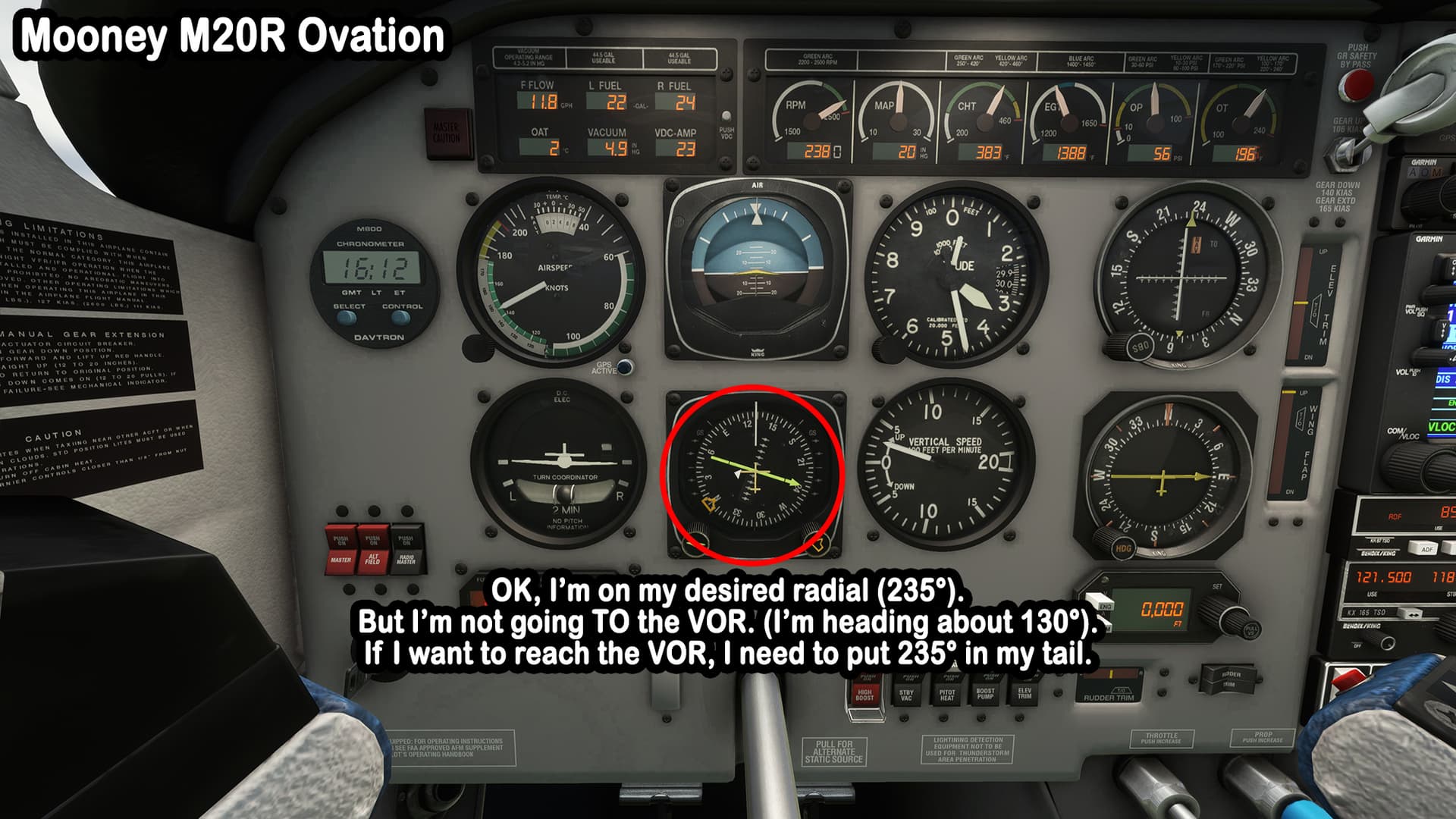
In practical terms, if you catch a VOR and want to go there, you select with your CDI’s “OBS” knob the radial you’re onto (until you get a straight centered line in your CDI/VOR indicator or just a straight line if you have a nice HSI instrument [basically: CDI + Compass]), you turn your aircraft in the direction “TO” of this radial (the radial heading is exactly in your tail) and that’s all. You’re heading to this VOR in the shortest straight path. Easy peasy lemon squeezy, right?
Don’t panic!
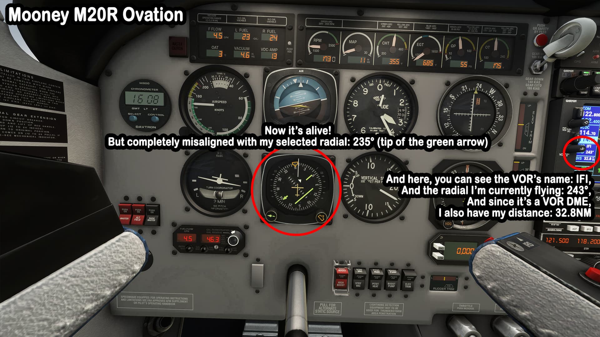
Let’s demonstrate this with a few pictures of two different configurations. One is from the Cessna 172 Skyhawk “classic”, which has separated Compass and CDI/VOR instruments. And the other one, for the fancier Mooney M20R with its beautiful “all in one” HSI.
First, let’s see the Cessna:


And then, the Mooney:


- Yeah, but how do I set up my CDI/HSI/whatever? How do I know if I’m “from” or “to”? Why are you mean with me? Why can’t you share a PLN file, so I can set the Autopilot on and just chat on the radio with the group without thinking about anything? So many questions, so little time!
- I know, I know, hold your horses, we’ll discuss this later… But no. No PLN file today. Deal with it.
And on this terrible transition, let’s continue the theory…
Pushing a bit further with theory
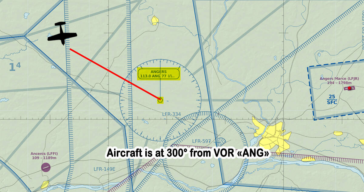
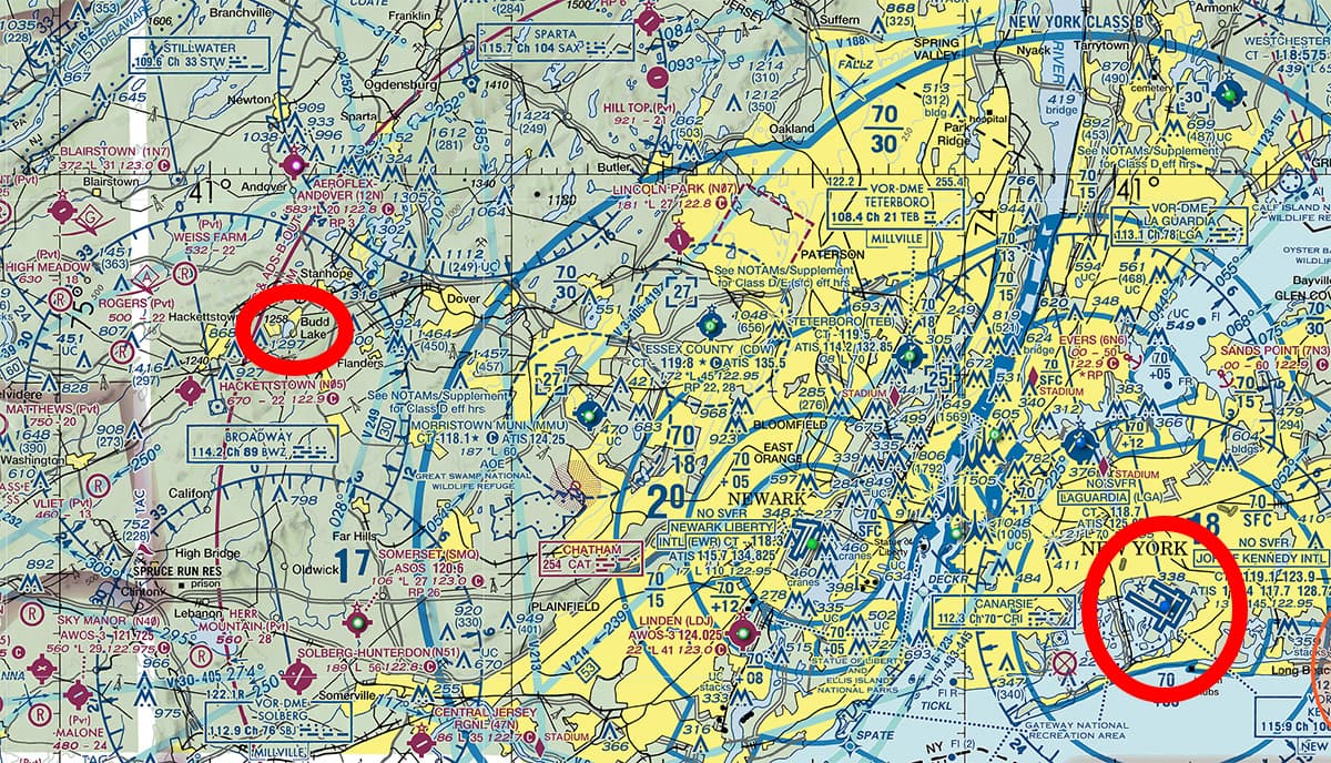
We don’t always want to go to the VOR location. Most of the time it’s not at all what we need. You should see them as anchor points rather than targets. Let’s do some basic geometry here. So I’m in KJFK and I really want to go to Budd Lake, north-west from my position:
I can already calculate my heading (you can do all this planning stuff with free tools such as SkyVector website or LittleNavMap app):

So now, if I head to 300° in a straight line, I know I’ll reach Budd Lake at “some point”. Yeah, but when? Where exactly is this point? How can I ensure I’m at the exact spot and not any generic and boring lake just before it or just after the extraordinary Budd Lake?
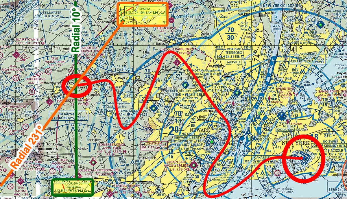
Maybe we can use this VORTAC (Sparta : SAX) to help us?

And if I trace a line from the VOR to my waypoint, we have an intersection, hurray! (yes, that’s the geometry part.)

So, this line that shoots from the VOR… Isn’t it a radial? Yes it is! Radial 231° to be precise.

We can conclude that if I head 300 degrees from the center of KFJK (yes, that’s quite a large approximation that will probably make me drift a lot), and I set up my radio nav to the frequency of the SAX VOR (115.7 MHz), and I select the radial 231° in my CDI/HSI, I should be at this precise waypoint the moment the CDI becomes a straight line (centered line for basic CDIs, just a straight line for advanced HSIs).
And doing this: “heading from a precise spot towards an identifiable landmark confirmed with the help of a VOR” makes you do precise VFR flights. Congratulations! You can turn off your GPS from now on and throw your maps out of the window. If you carefully planned your flight, you shouldn’t get lost.
And even better, some aircraft can handle two VORs as they have two CDIs. This means you can do your navigation without having to fly straight following a specific heading. As long as you arrive at the point where the two CDIs become centered (where their radials cross):
Knobs and stuff
It’s time to put all this theory in practice. At this point, if you understood (or maybe even already knew) everything above, be reassured, what’s coming next is really easy and shouldn’t be scary at all.
We’ll address two types of radio nav instruments:
- The classic ones
- The modern/glass cockpit versions
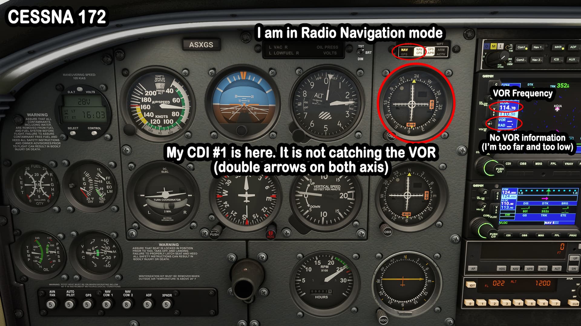
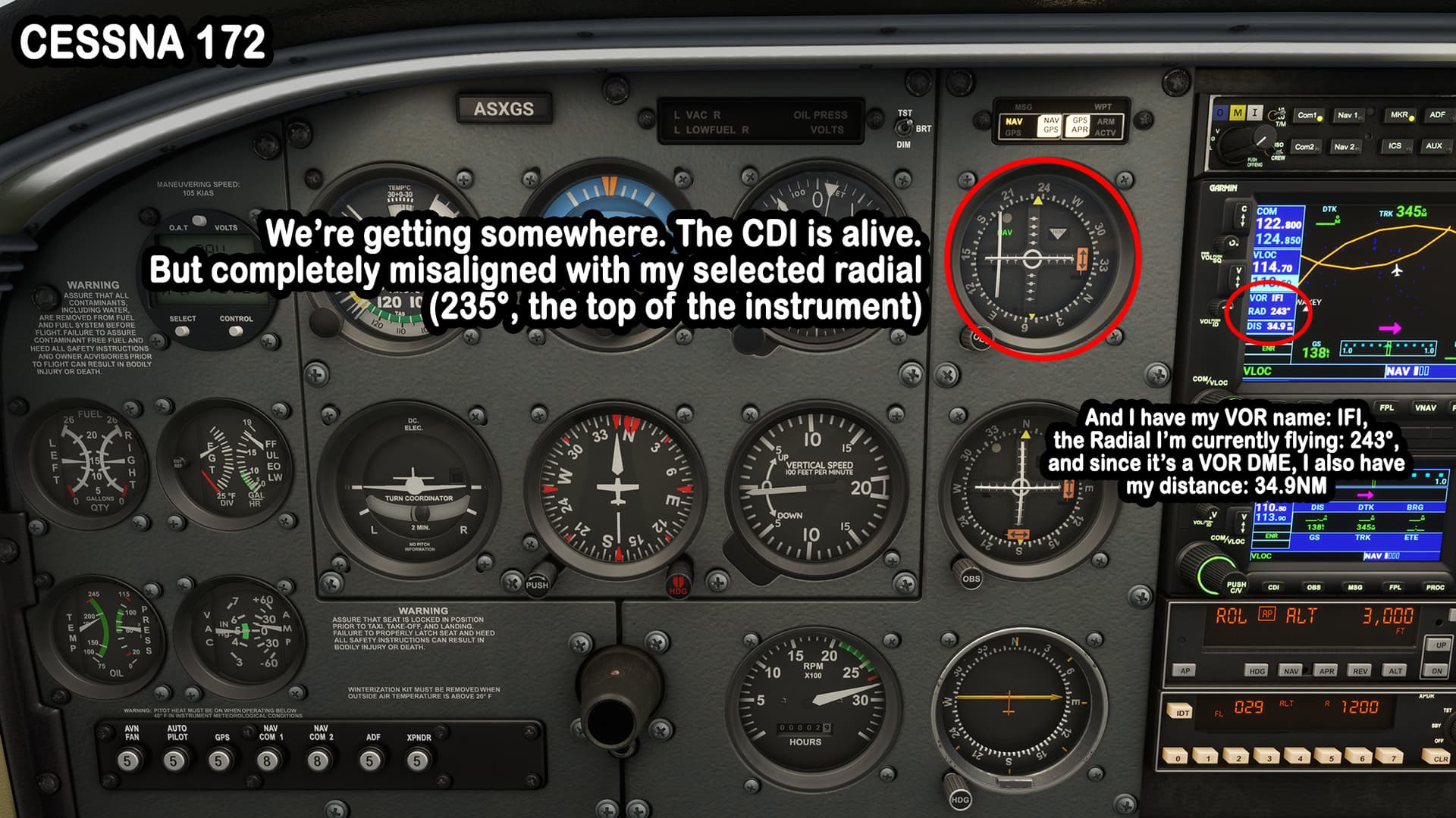
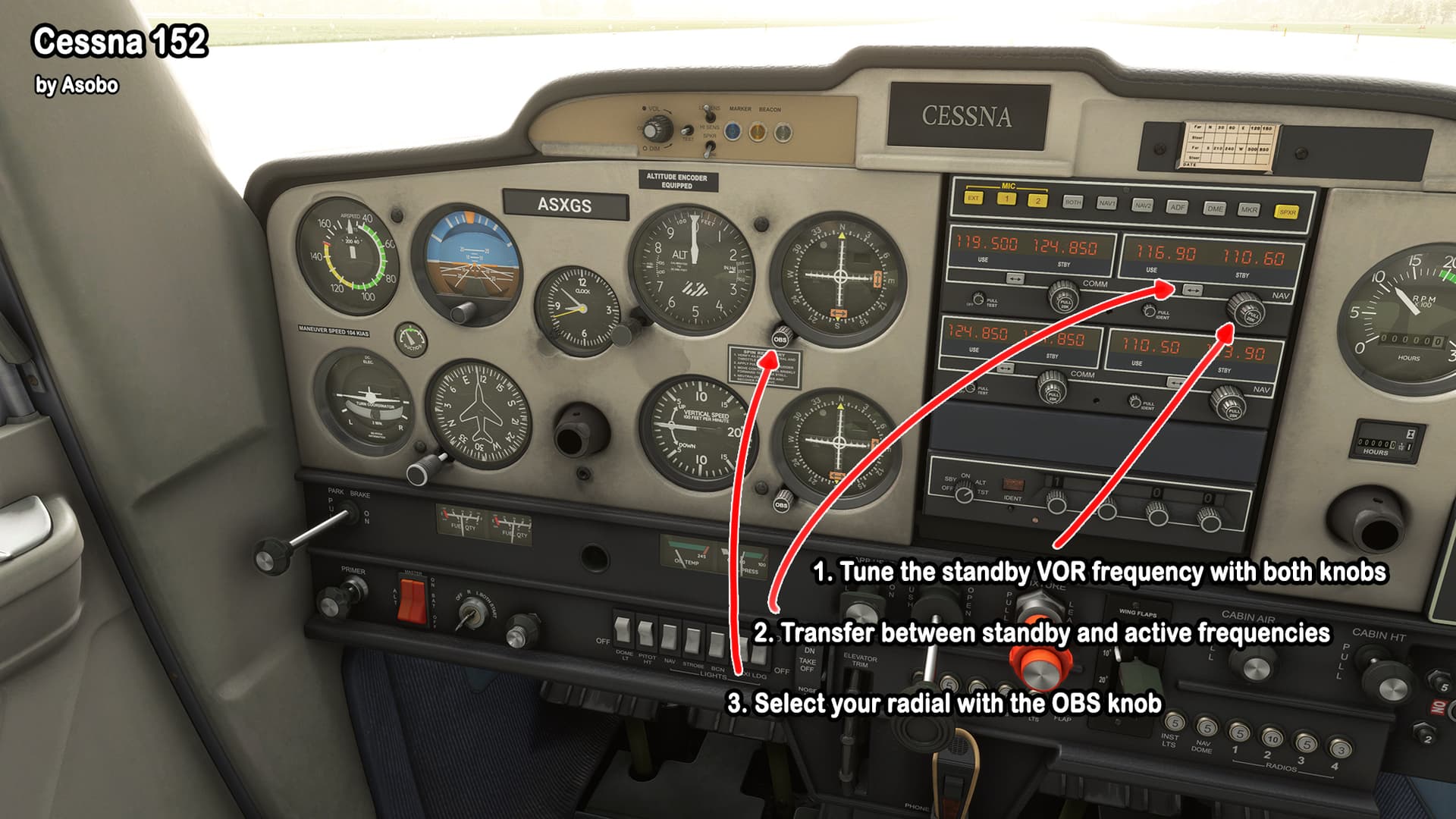
Classic versions
On “old-school” aircraft, you often have to press “CDI” button to change your navigation source from GPS to VLOC/RADIO. Then select your VOR frequency with the appropriate knobs. It sets it in the standby frequency. And you transfer between active and standby frequencies with the <-> button.
Once you’ve done that, you might have immediately the info of your VOR on the screen, if you’re at a reception range from it.
But whether you reach the VOR or not, you can already turn your “OBS” knob on your CDI (be sure it’s the CDI related to the VOR: if you have two VORs channels, you also have two CDIs in your plane, so you have to figure out first which relates to which).
At the end, put the radial at the very top of your CDI or the arrow of the VOR aligned with the radial you want, on your HSI. A few examples:


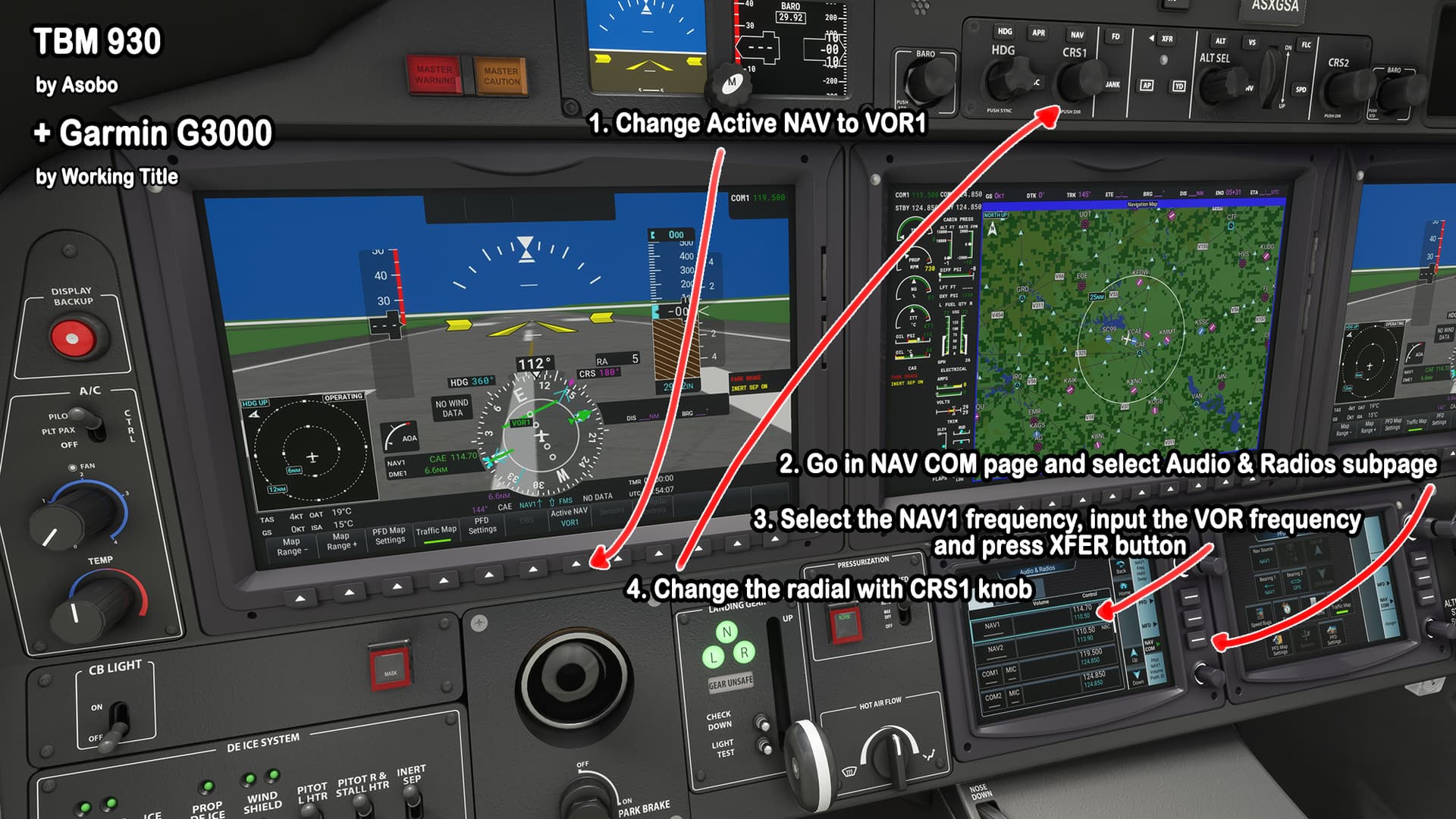
Modern versions
In your main display (PFD), set your CDI option to VOR instead of GPS/FMS. Then look for the radio/navigation page of your Garmin G1000, G3000, etc. Enter the VOR frequency in the “NAV” section. And press the <-> to switch it from standby to active frequency.
Then turn your “CRS” knob, so the number matches the desired radial.
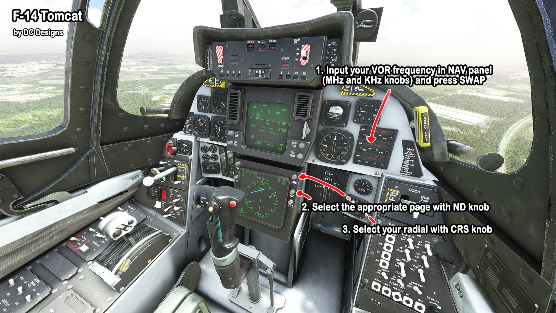
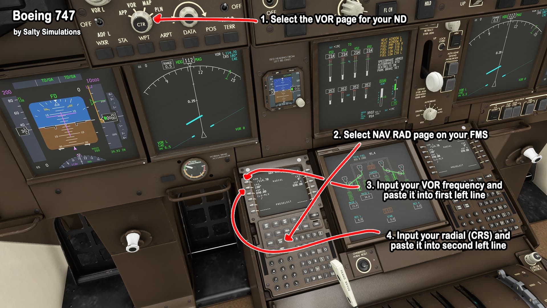
Of course, each plane has its subtleties, but here are a few examples:


Congratulations
Now that you know everything, I hope you’re ready for this Saturday special event. It should be fun, I hope it won’t be too complicated and people will listen to whoever is willing to give more details and explanation live (possibly me, but I hope a real pilot could do it. Fingers crossed!) I let you check all the necessary links below:
Important Event Links
RECOMMENDED SCENERY/AIRPORTS:
- We Love VFR - Region 1 » Microsoft Flight Simulator
- Powerlines and Solar Farms » Microsoft Flight Simulator
Other Information
Please post event screenshots in the #screenshots channel.
Voice channel highly recommended even if you can’t speak. We tend to have a lot of fun in voice ![]()
And if you participate to the conversation, don’t forget to use push to talk.
Discord
Make sure you have the Desktop App Running Before Clicking the LINK!
Flight Plan... if we can call it like this

Or the PDF version below: