As I understand it: using the LNM for full flight planning, and then exporting a LNM made plan to MSFS has the problem, that the SIDs and sometimes the STARs are not recognized correctly. But they should show as waypoints in the MSFS plan anyway (that’s what I experienced). So no need to add a procedure inside MSFS. ATC was fine with the few fully LMN planned flights I flew so far.
That’s funny, for me SIDs and STARs import just fine, but I never get the approach right.  It shows as “automatic” and I need to select it manually – which messes the arrival and require a bit of cleanup.
It’s the same with SimBrief, Navigraph, STKP.
1 Like
I never set the approach before the flight (only the STAR). I fly with live weather and like the “realism” to not know, what rwy it will be at approach. And sometimes it reallly changes due to wind changes on destination during flight.
So that problem didn’t occur to me.
Can confirm this. Got worse with the last update. At least this is my impression.
You can also select “File” → “Export Options” → “Export Waypoints for SID and STAR” in LNM. This will convert the procedures to a list of waypoints which should normally always load.
Alex
3 Likes
I tried that with one of my last flights. Just out of interest, what’s happening.
The exported plan “deleted” the complete SID (and the according WPs) inside MSFS. I switched back to deactivate the function. And then it works like I would assume the actual function should work: a SID planned by LMN was not recognized as SID in MSFS, but the waypoints were there; whereas the STAR was fully recognized as a STAR by MSFS.
I’m not sure if one can reproduce this. Maybe it was a one timer…
EDIT: see here. SID and STAR were planned by LMN (LMN “Export as wp” function OFF). SID is not recognized - but wps are there - STAR is recognized.
Hi can someone please let me know if I set a gate as a departure point in LNM do I need to then select the same gate in the MSFS flight plan screen or will LNM load me straight into that point? I use Self Laoding Cargo hence the need to have a jetway connected to start.
Thank you
Yes, you need to select it again in MSFS. Use the drop-down menu for that, by the way, zooming in the map and selecting it there will mess your plan.
2 Likes
Thanks for that pal
Hi, I have a question about how to use Navigraph. When I have “Use Navigraph for all features” enabled, the airport EHVB (south east of Amsterdam) is not visible. However when I select “Use Navigraph for Navaids and Procedures” the airport EHVB appears on the map. The airport is also present in MSFS2020.
The airport is a former Navy airport, which is perhaps why it is treated differently. But I wonder, when I want LNM to match MSFS2020 as closely as possible, what Navigraph option should I select in the Sceneray Library>>Navigraph menu?
I’ve noticed the same. I switched back to Navaids and Procedures and life has returned to normal. 
1 Like
Finally gave LNM a try…I’m runnig it on a mac networked to my Windows PC. It works great except when it came to me seeing how you can change the maps to VFR, etc that I had seen at AVSIM. The problem is…the Mac version of LMN doesn’t seem to have to folder structure that the Windows version has so I can’t seem to import new map overlays onto my Mac? Is this correct or am I missing something?
The maps are buried in the Little Navmap.app. Select Show package contents (or similar) in the finder on LNM.
Maps are in Little Navmap.app/Contents/MacOS/data/maps/earth.
This is the folder where you have to put the individual maps like google-maps-ter.
Alex
2 Likes
Have a look at chapter Navigation Databases in the manual. This explains the limitations of the different modes and what navaids are fetched from what database.
Alex
1 Like
Perfect, found it and have them working, thanks!
Thanks, that was helpful to read. If I disable navigraph, then LNM and msfs2020 will show the same data. But if I want to make sure LNM shows current real world procedures/navaids/airports, then I have to switch to a current navigraph database.
Thank you. I looked into the section. I still cannot keep the aircraft / map centered and it not interfering with the zoom that I set. It still zooms me in / out. If it had a toggle / option to keep it centered by at the zoom level set by the user, that would be great.
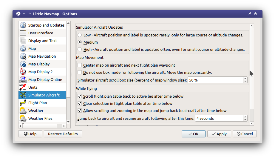
Not a great but a kind of a ‘workaround’ is go to options >simulator aircraft> check ‘allow scrolling and zooming in the map’ and set the jump back to the maximum value allowed. Then I have to fix it every 99 seconds vs every 10 seconds (default).
If there was a way to keep map centered at the zoom level set by user, that would be awesome.
Everything else looks and works great. Highly impressed. Thank you!
With the settings below there are two important gestures while the program is centering the aircraft:
- Zoom first with wheel, keyboard or anything else: Changes zoom value and keeps it while centering the aircraft. Do not move the map. Otherwise it will not keep the zoom value.
- Move the map first to find an airport besides the plan, for example. Then zoom in out, move around, whatever you like. Program jumps back to previous zoom value after four seconds inactivity.
Using 1. the map keeps the aircraft centered and you can still change the zoom.
This all sound incredibly complicated but it is simply meant to minimize pilot input and keep the map around the aircraft with the least input.
WP NDB in the Netherlands is no longer active - I believe it was decommissioned quite some time ago. It illustrates (yet again) why I much prefer Navigraph over NavBlue to set the default sim nav data - even though the Navigraph core data is still in beta.
In default MSFS, (using NavBlue) the two ILS approaches at my home airport still have outer markers, even though both OMs were decommissioned in 2015.
1 Like
For LNM users, this may be interesting https://forums.flightsimulator.com/t/release-littlenavmap-toolbar-window/296952
1 Like