This is the downside with simulators, they usually need to be supplemented with third-party software to work satisfactorily, and it has nothing to do with Asobo’s sloppy programming, it’s about money, real updated data cost money.
In all my years of flight simming I never bought any nav addon for any sim.
They all work sufficient satisfactory. 
1 Like
Not sloppy programming, this information is always in flux in the real world thus there are processes to publish updates on a cyclical basis. The Airac is updated by Ms/Asobo but only when they push out other updates.
If you are using a tool like little Navmap, once you sync the database with MSFS things work fine, but if you use SkyVector which is a real world planning tool, you will have discrepancies. If you only stick to MSFS and Little Navmap after syncing their databases you don’t. Just remember to re-synch Little Navmap with MSFS when MS/Asobo update to the new Airac.
Because I like to use real world planning tools, I find the convenience of a Navigraph subscription worth the cost. It makes keeping all the tools I use in sync easily.
1 Like
Are you sure? I always thought that the Nav updates are the small in between updates.
They may be , but they definitely do not updated at the same time the Airac is released. Which adds to the confusion, needing to know when Asobo updates so you can update your tools and trust the real world tools, or taking charge of the updates yourself.
For the majority I would guess this cost of a subscription is not worth it since many will not be using real world planning tools and if they use “in sim” planning tools, will never have a problem. It is just an option for those of us that want that level of realism and immersion. Definitely not necessary and I only offered it as a solution for those who are interested in such depth.
2 Likes
And having access to Navigraph charts in the game is an advantage that alone is worth a subscription.
3 Likes
I feel happy for everyone who has money for Navigraph subscription and wish you all the best:) However, for me one of the reasons to pay for MSFS was this - " NAVBLUE will provide real-world aeronautical data to Microsoft through its Navigation+ and, post launch, Charts+ services, to support the realistic experience that is the next generation “Microsoft Flight Simulator” software."
2 Likes
And… the problem started right there… it doesn’t say Jeppesen will provide real-world aeronautical data…
1 Like
pj
Welcome  but this is the wrong thread. It’s about NAV, not COM.
I don’t know why nobody mentioned this, but some of the glass cockpits (especially G1000) can give you information about all in-game frequencies in the “Airport information” mode, even for distant airports. I use it for obtaining ATIS frequencies as they are also out if sync with the real world data.
The main drawback is when the airport has several ILS systems, you may not know if you’re using the correct one. But it’s an easy fix if you write down all frequencies and have them ready when needed.
Actually, the question arose because of the OP’s confusion with COM & NAV frequencies, so the link provided was a good one to help them…
From the link:
VHF civil aircraft communications are placed in the 100 MHz band and allocated 760 channels within the range from 118.0-136.975 MHz. As a pilot, every frequency you talk on will fall within this range. VOR navigational frequencies are allocated to the range from 108.0 to 117.975 MHz, positioning them just below the communications range.
ie.
NAV: 108.0 to 117.975 MHz
COM: 118.0 to 136.975 MHz
so, in the OP’ Question
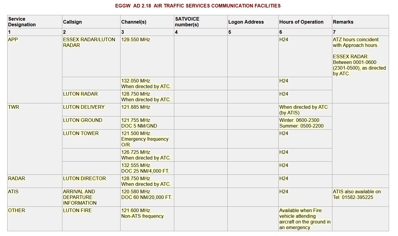
- 118.95 Mhz is a COM freq (not a Nav freq for an ILS)
- 120.580 Mhz is also a COM Frequency
but I do not see either of these two Freqs associated with Luton.
For Luton
- ILS RWY 08 is 109.15
- ILS RWY 26 is also 109.15
===========================================

I guess it has been said already but this can’t possibly a NAV frequency, let alone a ILS frequency. You could look up the information in the countries eAIP. For Europe you could find those easily online, not sure about other parts of the world.
Neh its Jeppesen, Navblue is way better (at least in Euppe). Jeppesen is a cluttered mess in comparison.
Since when is Skyvector a real world planning tool? Is it approved for real world navigation, that is new to me… On top, I almost never run into the problem where things have changed so dramatically from one airac cycle to the next that the in-sim planning system becomes useless, its a minor inconvenience at worst.
Bigger problem with the in-sim planning system are the enormous DME arcs to the IF when you insert an approach, even the SR71 has a tighter turning radius at Mach 3.0.
Exactly. The info should be easily accessed in the sim, both in flight planning map and in-flight. It worked in FS9 and FSX…why not now?
1 Like
I did not know I can get Navblue charts integrated in the game, link please?
You can’t as far as I know, I have it on my iPad (paid by my employer). I will never use Jeppesen again, Navblue is way better. No idea what the price of a charts+ subscription is.
Skyvector is for real world flight planning – SimBrief isn’t -
Never said the in simulation flight planning was useless - just if want Skyvector, Foreflight and other RL flight planning tools in sync with you in sim and simulation flight panning tools - Navigraph is a convenient way to do so. If you are happy without it, fantastic no need for the third party add-ons – they are optional
Here is a podcast with the CEO of Skyvector for your perusal -