When I have the taxi ribbon turned on and try to taxi at KRUT from the general aviation parking area, the ribbon always takes me to runway 19. But due to the wind, I want to depart from runway 31. Even if I use the ATC menu and select runway 31, the ribbon still leads to 19. What am I missing?
I get the impression that if I talked to a tower and got permission to depart from 31, the ribbon would change to lead me there. But at KRUT there is no tower.
If it’s a consistently reproducible error, you might want to submit a bug report. It’s probably not going to get fixed anytime soon, but at least it will be on the list to get looked at eventually!
Regards
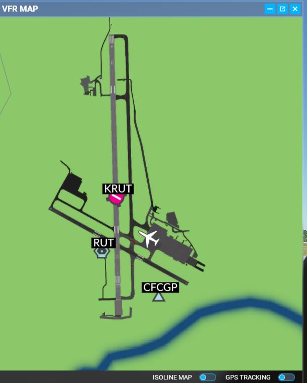
I’m new at Flight Simulator. I have a map of the real-life airport. It’ a known limitation that most airports are not high fidelity (that is, star airports). It’s hard to find my way around the virtual airport because I don’t have a map of the virtual airport, only the real one. Are there any suggestions on how to make Flight Simulator show me a map of the virtual airport?
Howdy! I recommend using LittleNavMap and keeping it on a 2nd screen or alt+tab to it. If you zoom all the way in you can see the airport and parking spots.
Yea they teased “charts+ Programs” as part of their partnership announcement last year, but it’s been very, very quiet on that subject since release. Hopefully they add this capability before “too long”.
Regards
Very helpful. Turns out that PDF that was provided to me in 2021 is actually from 2014. Time to go over to the airport and look at that large paper map I saw in an office and see if it’s up-to-date.
Last time I flew as aircrew, June 2021, I didn’t notice any blue edge marker lamp right in the middle of taxiway A, as shown in Flight Simulator.
I also recommend using LittleNavMap for this. One thing that’s particularly useful is that LNM labels the airport taxiways using the MSFS database, and for non-star airports MSFS does not always match with the real-world charts. I’m pretty sure the built-in VFR map does not include taxiway names.