Ah, I had thought that’s what the little ribbon leading out from the airport runway on the approach chart indicated?
Examples:
ZBAA RW 36R will capture the glide slope at 6890’ at exactly waypoint D20.9/PEK with a heading of 359° with a 3° slope:

Based on what’s being said, you guys are saying you could theoretically capture this glide slope much earlier as long as the 3° descent angle is met? This doesn’t make sense to me. Eventually the antenna broadcasting the ILS frequency for that runway will be out of range. Sure the pilot can manually be on a 3° slope based on aircraft input, but not the captured ILS glide slope.
In contrast, here is one that seemingly doesn’t even make it 10NM out, and attempting to capture at 3000’ at 10NM would seemingly be ineffective here:
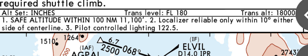
CYPR RW13:

If I’m incorrect about the range, what do those little ribbons widening out from the runway mean? My understanding is they also show the width of the localizer range - many of which specifically state on the chart that the localizer will only be reliable if activated once within 10° on either side of the runway centreline - which is why I generally never turn on LOC mode until making the final turn to straight final, and it’s nearly complete/straight:
Thanks for your feedback here. I am quite good at executing ILS landings by interpreting the approach chart data, but still have some details to learn.
Cheers and very kind regards in helping clarify this for me!
![]()