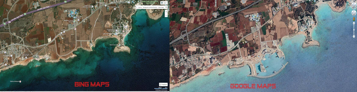
Perhaps in most cases Google Earth has better imagery and photogrammetry of more regions of the planet. That’s not surprising since Google have been at it far longer than their competitors. Are they the superior product? For the most part, yes. In some cases, you’ll see some areas where Bing may have better, more current data, but as a whole, Google has the better data.
However, hoping that Microsobo will switch to Google from Bing is a non-starter. That’s like requesting that Chevrolet start using Ford engines in their cars because Ford engines are better (not necessarily saying that’s the case, just a hypothetical situation). There isn’t even the most remote chance that they would ditch their parent company’s mapping service for their biggest competitor, even though it may be a superior product. How anyone considered that wish list item posted above as viable is beyond me.
The Bing maps team is hands down the laziest team in the entirety of Microsoft. They keep updating only regions which already have photogrammetry data once in every 10 years and focus on mostly western regions only. They never bother to acquire or atleast commission a third party vendor to fly photogrammetry missions anywhere else on the planet. No wonder their feature discovery series episode was so bland.
I completely agree - I’ve been flying in Crete with Neofly since the VR update and I just can’t get enough of it, at the expense of all my other sims.
The same point I was trying to make about landmarks has stood out for me there as well, though - there are many tourist flights, where you fly to a location (a POI) and fly around it while your virtual tourists are taking photo’s. I did one a couple of days ago where the POI was completely missing from the sim, so I had to guess from audio hints by the controller, where the POI was supposed to be. What should have been a 10 minute flight stretched to over half an hour.
I’m not complaining - nor have I at all in this thread (or any other in fact) - just making a point and also disagreeing with those who simply discount the OP and make out he’s some kind of silly person (for want of another phrase).
Actually that’s not how photogrammetry is made. They need aircrafts flying over the areas they want and capture a lot of pictures from all directions. They can’t extract 3d buildings from satellite imagery, not the way photogrammetry does.
i could have expressed myself better, you are right. of course you need the aerial images from different perspectives to generate 3D data from 2D data. the top-down view from satellite imagery only gives you ground textures and 2D positional informations.
i was trying to stress that these (google) 3D models were being generated by algorithms and not humans. granted, they look silly if you get really close, because the mesh algorithms produce holes and false angles, depending on the source imagery.
Actually it’s a mix. The software stick the images together to form the 3D scenery, after that, both automatically and manually, corrections are made. Those corrections try to improve the general looks of it. I think the partnership video with Bing Maps shows them correcting the photogrammetry manually.
Did someone got any useful information on implementing actual Bing Maps into the simulator? The satellite data displayed in the “game” is at least (like you stated here) a couple of years old…
The imagery in MSFS is the same as in Bing Maps. In some areas it‘s even more recent (after the world updates). it‘s a Bing Maps problem, not a sim problem.