Correct. E.g. at 1023.2 and ISA +20 alt is 5940ft, which is the same deviation as in the stnd QNH case.
Thanks, so the problem is only with temperature …
Then there still is this error which might it might not be related:
https://forums.flightsimulator.com/t/high-altitude-altimeter-setting-wrong/418320?u=nijntje91
It would be nice if someone can send screenshots which includes the ambient pressure from simvar watcher (whatever that is ![]() ) in flight or on ground at a high elevation airport. With standard (29.92 / 1013.25) set and varying conditions:
) in flight or on ground at a high elevation airport. With standard (29.92 / 1013.25) set and varying conditions:
- ISA (standard temperature and pressure)
- ISA +20 at standard pressure
- ISA -20 at standard pressure
- ISA temperature at lower than standard pressure
- ISA temperature with higher than standard pressure
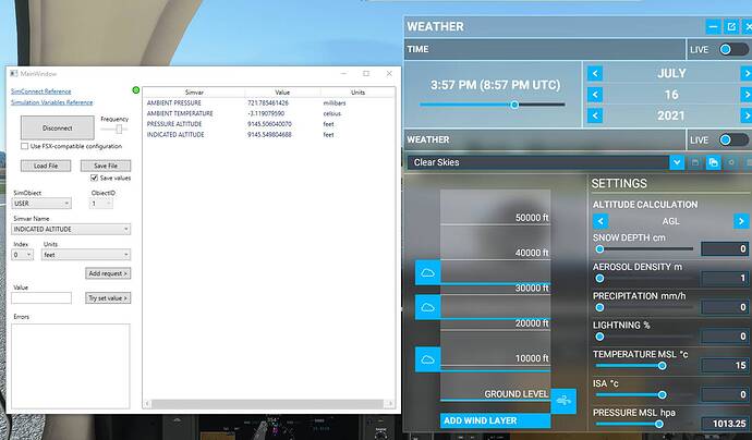
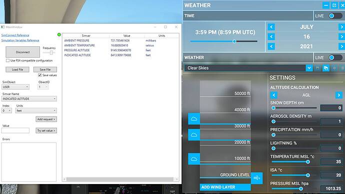
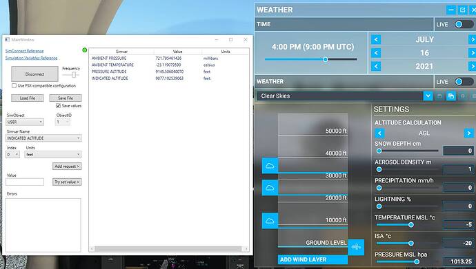
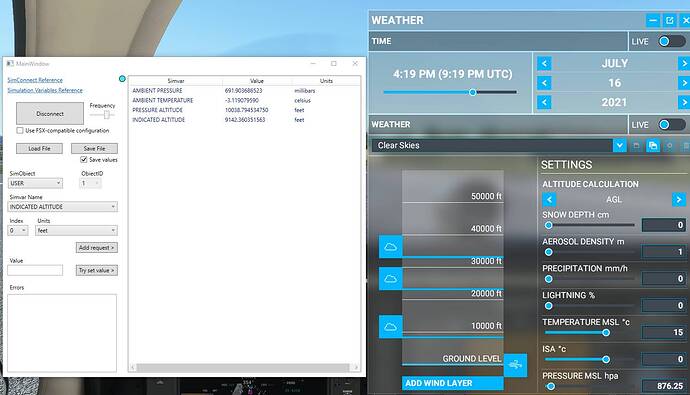
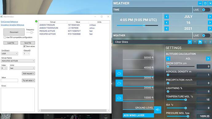
Here you go, taken at SEQU
ISA
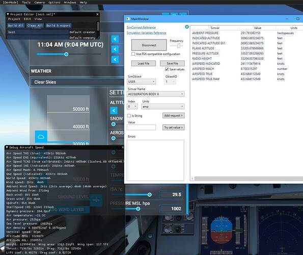
ISA +20
ISA -20
ISA at lower than standard pressure
ISA at higher than standard pressure
Hope this helps.
Cool! Is this with 1013.25 set (on the altimeter)? I’m wondering what this indicated altitude in SimConnect is referring to.
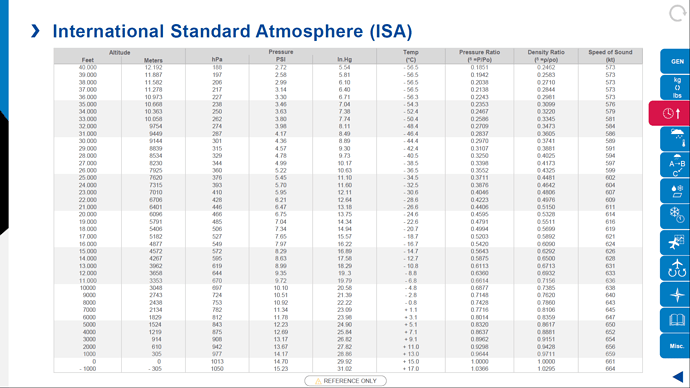
At first glance the pressure altitude seems correct compared to the ISA table. I’m wondering why the indicated altitude changes, if the altimeter is set to standard (1013.25 / 29.92) the indicated altitude should mimic the pressure altitude.
By the the difference between pressure altitude and indicated altitude is exactly 4 ft per 1000 ft per 1C.
The indicated altitude simvar is basically what altitude the altimeter will display, in these examples that’s with the baro set to QNH using the ‘b’ key, after I made changes to the MSL pressure. On a quick glance this does seem to support the theory that any temperature/pressure deviations from ISA are calculated from MSL to the current altitude, instead of from ground level to the current altitude.
Ah ok, could you do the same with the altimeter set to standard to see the effect on pressure altitude?
I have the feeling this temperature effect is directly applied to the indicated altitude rather than affecting the actual pressure lapse rate.
But I think we can already confirm this looking at this screenshot from @AwarePlot117729 in another thread. Indicated and pressure altitude are disconnected with altimeters set to standard… Although pressure altitude itself also seems to be off.
250 hPa should be 34.000 ft pressure altitude, calculating the pressure altitude myself, I end up with 33.848.5 ft instead of 33.538 ft…
@anon50268670 and indeed, leaving the altimeter set to standard there are discrepancies for both above and below standard pressure
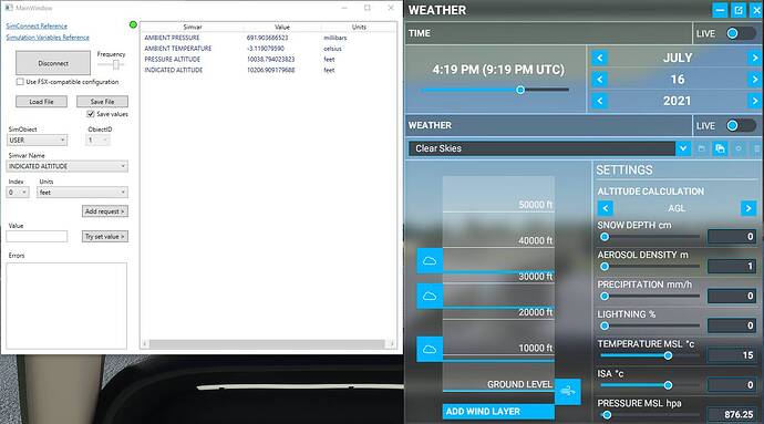
Below standard
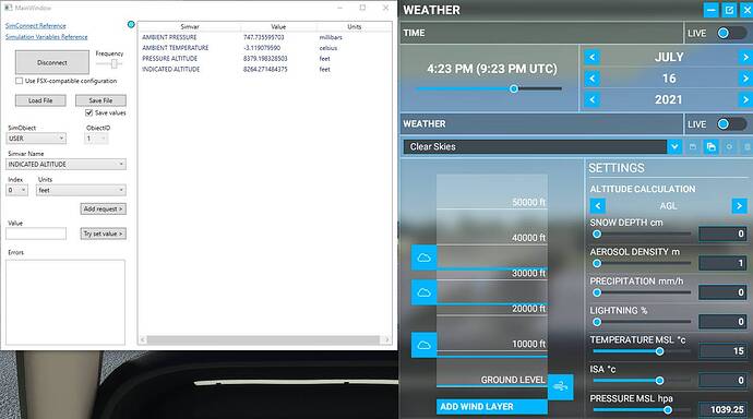
Above standard
Indicated versus Pressure Altitude with 1013.25 / 29.92 Set
When I calculate the pressure altitudes myself with the formula:
- Pressure altitude = 145442.15*(1-(P/P0)^0.190263)
These are the results (matching with ISA tables):
-
Situation 1 = 10182 ft instead of 10039 ft
-
Situation 2 = 8170 ft instead of 8379 ft
So pressure altitude itself is already incorrect. Second the indicated altitude should of course directly mimic the pressure altitude with 1013.25 / 29.92 set. And this is without introducing non-standard temperatures which also seems to have an affect! I don’t get what they are trying to simulate here…
Effect of Temperature on Indicated Altitude
These exactly confirm what we have been suspecting. The difference between pressure altitude and indicated altitude is exactly 4 ft per 1000 ft per 1C ISA deviation. First of all temperature shall not affect the indicated altitude in these cases as in both cases the correct QNH (= standard) is set and the aircraft is at ground level. With correct QNH set at ground level the altimeter shall read field elevation regardless of temperature!
In both cases the difference between pressure altitude and indicated altitude = 732 ft, which exactly matches 4 ft per 1000 ft per 1C ISA deviation: 4 * 9.146 * 20 = 732 ft!
They might as well bin everything related to altimetry and start from scratch…


 TO SUMMARIZE ALTIMETRY ISSUES


How it should be
Without knowing how exactly all of this is programmed, this needs to be the end result:
- Pressure altitude versus ambient pressure shall match ISA tables!
- With the correct QNH set on the ground → the altimeter shall read aerodrome elevation no matter the temperature.
- Standard (1013.25 hPa / 29.92 inHg) set → altimeter shall read pressure altitude, no matter the actual QNH or temperature. If QNH is standard with the aircraft on ground, the altimeter should read pressure altitude = aerodrome elevation.
- With non-standard temperatures the pressure lapse rate needs to be affected in such a way that the true altitude versus indicated altitude differs. This temperature error shall be based on the aircraft height above altimeter setting source (aerodrome level) and NOT mean sea level! At aerodrome level, temperature error is → ZERO!
What is wrong
I think the main issue is that MSFS is calculating altitudes from Mean Sea Level instead of aerodrome level. The “altimeter setting source” (aerodrome level) should be the starting point from which the altimeter, with aircraft on ground and correct QNH set, reads aerodrome level, all errors (except instrument error) are zero. From the examples I’ve seen, I think the following is going on:
- Pressure altitude calculation has an error in it, it should follow the ISA tables.
- Temperature error seems to be applied directly to the indicated altitude rather than the temperature affecting the pressure lapse rate. For example when flying with 1013.25 hPa / 29.92 inHg set, the altimeter shall read pressure altitude no matter the temperature. From the examples above you can see that this is only true at ISA, at non-standard temperature the difference between pressure altitude and indicated altitude exactly match 4 ft per 1000 ft per 1C ISA deviation, which is completely wrong!
- The temperature error seems to be applied to the aircraft height above sea level rather than the aircraft height above ground level. The altimeter is calibrated according the pressure lapse rate in standard atmosphere, the QNH is calculated using the standard pressure lapse rate in the same way. In other words temperature shall not affect the indicated altitude on ground with the correct QNH set. With QNH set and on the ground the altimeter shall always read aerodrome elevation.
- Don’t use the 4 ft per 1000 ft per 1C ISA deviation rule of thumb. Its just that, a rule of thumb, and not even a good one. Its not allowed for use in the real world for temperatures below -15C. Let alone something to base your whole atmospheric model on… Its a little worrying to see Asobo relying on very rough rules of thumb rather than using an exact approach, the same is true with surface wind versus wind above friction layer for example (50%).
This still doesn’t explain the difference between indicated and pressure altitude when 1013.25 hPa / 29.92 inHg is set. With the altimeter set to standard pressure the altimeter should read pressure altitude no matter the conditions. Temperature and pressure need to affect the pressure lapse rate rather than those errors being directly applied to the indicated altitude, causing a disconnect between the indicated altitude and pressure altitude (I assume that is what MSFS currently does).
Sources
Temperature correction according ICAO PANS-OPS (Doc 8168):
Pressure altitude calculation:
International Standard Atmosphere Table:
@Jummivana @OlieTsubasa443 These are quite significant flaws and it would be good to correct these before release, it would likely cause a lot of complaints otherwise. Rolling back to how it was before this BETA maybe? In the current state these altimetry changes are not ready for release. I don’t see any of the altimetry posts labelled with [BUG LOGGED], are the devs aware of this?
Yes, @anon50268670, you have summarized the situation well. This is the same info that I have been supplying separately to the Asobo devs.
They have acknowledged that what is in the preview is wrong, but they will not be able to fix it in time for the public release. I advised them in that case it would be better to revert back to the previous version, which was also incorrect, but those errors were much more benign. From what I gather, I don’t think they will be able to do this.
Disappointing, I think they should at the very least let everybody know this as a “known bug” and / or release a hot fix as soon as possible to prevent the community go mad… Especially because it seems to have a lot of other implications looking at this forum than “just” a wrong indicated altitude.
I’m just wondering, other than us testing these kind of things during the Beta, is anyone informing them before / while they work on these kind of things or are they just doing what they think is right? I know some of the devs have a PPL or are otherwise engaged in aviation but apparently it doesn’t cut it…
I don’t know if it got fixed in the meanwhile but this is also a perfect example:
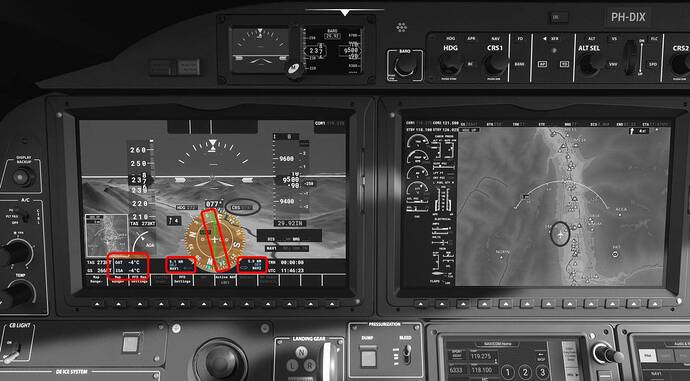
- Instead of showing ISA deviation, the temperature it would be in standard atmosphere is shown.
- The bearing pointers / RMI needles pointing to the localizer antenna like its a NDB or VOR.
I think these things have nothing to do with a lack of programming skills, but rather not understanding the concept of what is being programmed …
Another bug is the weather engine doesn’t support values below QNH 983. For example, if going to somewhere where the QNH is 971, the sim uses QNH 983 as the prevalent pressure.
There should be some type of advanced notice to VATSIM sups. Otherwise, come July 27th, a ton of folks will be flying (on pc) with the wrong altitude and no one will understand why (at first). Already I’ve had a few controllers fuss at me and I have to kindly inform them it’s a “bug” without going into detail.
Unfortunately, I can confirm this bug still exists in the 1.18.12.0 update. @Jummivana Please pass along that this is a huge priority. If this bug is not corrected prior to launch, PC users will be put on blast while flying on VATSIM and many will not understand why. Clearly this is a complex issue, but one that will have a huge impact on VATSIM.
This is what I see at Paro, VQPR (Airport elevation 7364’):
-
I start with Live weather. Baro is set to 29.92. Alt is ~6600’
I press ‘B’ and Baro changes to 30.15 and alt to ~6850’ -
I change to ‘Clear Skies’. Baro remains at 30.15 and altitude changes to ~7400’
I press ‘B’ and Baro changes to 29.92 and alt to ~7190’ before it slowly creeps back towards the correct altitude.
Yes those deviations are temperature related and I assume this is with the new built so no change…
I guess MSFS clients will be blocked from VATSIM if this doesn’t change.
Well a lot of people have tried to raise attention to this issue, if its not being fixed, then so be it. With proper release notes it might have been caught a lot sooner.
I think I’ll still wait a coupled updates before reinstalling MSFS…
I can confirm that today with VATSIM, it was the same issue… at 14K, it was off by around 400ft and at 4k, I was off by 100ft and ATC reminded me a few times that I was not at altitude.
Here’s an example at FL380. I was off by 1000 ft
OK Asobo –
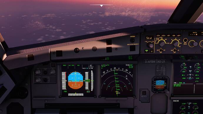
I am not an aircraft expert… but PLEASE FIX this bug!!! We’re almost a week out and the fact that the sim is not simulating correct altitude and most of the planes no longer do accurate STD barometer changes (when above transition level) is bad. As many above have stated, you can’t be taken seriously on VATSIM or others if you can’t even figure out what altitude level you’re really at.
I know there’s some back and forth but this bug is 100% reproducible, it’s been verified by countless beta participants… so why are we left in the dark on this? I don’t get it.
