Last time I circumnavigated in the TBM i went Eastbound and crossed the Atlantic between Fernando de Noronha, Brazil SBFN and Praia in the Cape Verde archipelago GVNP just off the coast of Africa. It enabled me to take in both South America and Africa on the trip without having to go really far out of the way.
Just curious, did you still cross the Pacific up at the Aleutian islands or could you chart a path across the Southeastern Pacific? Looks like Easter Island to Isla Robinson Crusoe is the key leg, if you can make that you are good for island hopping from Tahiti to Chile. But it looks just a tad far for the TBM.
Initially I wanted to cross the South Pacific as it has been done in the TBM in real life before, though they used auxilary fuel bladders to extend their range. This sadly isn’t possible in the sim AFAIK, and definitely not possible if you are doing the flight in FSE.
I looked at the Aleutian islands too, but decided to go further north via Anadyr in Siberia to Nome in Alaska as it is slightly shorter, and has significantly less time over icy water. Im not sure what the enroute airport situation is via the Aleutian islands, but it should be doable if you decide to do it.
I’m always changing planes for the stretches I’m flying. For long runs, I use CJ4 or the King Air. Under 1000nm usually the turbo Bonanza and for sightseeing I choose the fast and wonderfull VL-3.
1 Like
I am currently doing an RTW trip in the C172 G1000, left from central Canada in August. I am flying a couple of hours a day using VFR and real weather, which has resulted in the longest delay of four days waiting for the weather to clear between Greenland and Iceland. I am not using a set route other than East-ish. Lots of sightseeing along the way. Full tanks for the long legs. I decide the next leg each day at start up. Yesterday I did LGAV to LGHI, but am now doing LGAV to LTBA, as the flight from LGAV to
LGHI didn’t make it to the logbook for some reason.
The help I can offer is get in and go, deal with stumbling blocks as they arise.
3 Likes
Wow - I just downloaded it and it’s epic. I am just starting my own tour in a similar style… I have to decide whether to follow this or make up my own…
Do you know if there is a map of the tour anywhere? I did some googling but haven’t found one. If there isn’t, I may create one.
[edit] I just realised the tour download comes with a KML file which can be loaded into Google Earth 

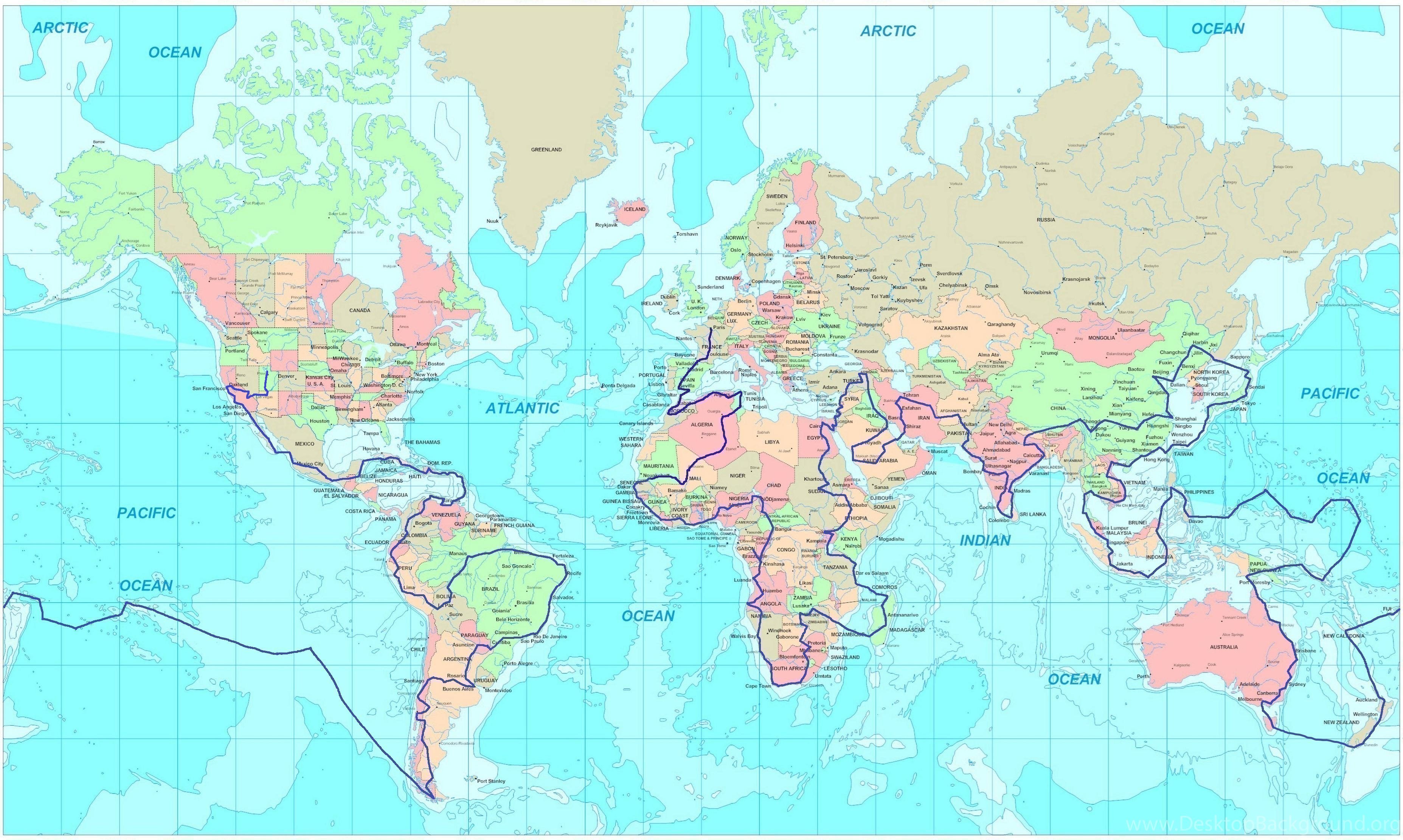
Yeah, it’s pretty amazing… I am on North America already, in Utah. What I did was download a large, high resolution map of the world, and I am marking my path after every flight with MS Paint 3D in a blue line.
2 Likes

Nice!!! Yeah, that is pretty similar. I believe it will make me do an S shape over NA, then Greenland, then on to Russia and rest of Europe. Ending in Paris, where it began.
1 Like
NA (KJFX) is actually where I started. Initially, I just wanted to make a coast-to-coast trip and at some point along the way I figured why the hell not?
The route planning has been pretty tricky at times as I aimed for legs not longer than two hours so I had to land on several “off broadway” airports.
I’m currently back in Europe / North Africa and doing all the scenic stuff. Approximately another ~35,000 miles to go until back at KJFK which should result in around 100k nms for the whole tour.
1 Like
Nice flightplan!
Don’t forget to fly around cape good hope.
I’ve done that once IRL in a rental Cessna 172.
Stellenbosch airfield also offer great coffee 