Be aware that you can’t really tell if you are taking the correct route using Skyvector, 9 out of 10 times your route won’t be accepted as it doesn’t really show one-way airways, minimum flight altitudes etc. I believe there is a paid version of Skyvector nowadays, however the free version is NOT used by real pilots! When I was an instructor the only thing students could use it for is crosschecking their tracks and distances, you can’t reliably create a route using Skyvector.
What point are you trying to make and who are you responding to? My comments are about real world flight planning, not flight planning in MSFS.
There are numerous reasons why landing with a slight tailwind is beneficial over landing into the wind. So this “always landing into the wind” does actually not always apply, it happens really often that aircraft are not landing into the wind for performance reasons. A departure towards terrain or obstacles may not be possible for a heavy aircraft so takeoff with a small tailwind over flat terrain is beneficial, an approach might have higher minima for one runway so taking the opposite runway with a tailwind might make you to see the runway in time to continue approach and landing. Maybe it just saves some taxi time when its not too busy. Just to give you some examples. Be aware that for performance reasons ATC will ALWAYS give you the requested runway, the only question is when, you might receive a delay.
I’m referring to the thread creator and his question.
That some people try to make this their contribution is as old as there are forums. And does not affect me perifer.
I still don’t get what you are after, is this not what the forum is all about? People making their contribution to answer the OPs question?
By considering factors like wind direction, the configuration of the airport, which runways are the longest, and choosing approaches and departures accordingly, you can increase the odds that ATC will approve your plan as filed.
How is that? You don’t file a runway, departure or arrival route, those are not part of the filled flight plan. Furthermore, ATC does not approve the flight plan, the FPL is approved by the Eurocontrol IFPS server. There is little to no human intervention when it comes to filling flight plans. The server just checks the filed route against the Route Availability Document, and minimum and maximum levels for that route. Usually there is a SID for each runway to the same start of en-route segment. Same for the STAR, there usually is a STAR from the same termination point to the IAF for the respective runway. If not, ATC will amend your flight plan by means of RTF or CPDLC.
I meant, if you choose SIDs and STARs that favor existing conditions, you are more likely to get to fly the plan as filed. You are right, the runway is assigned, but we have a lot of data to help us take an educated guess about which runway that will be, both for departures and arrivals.
1 Like
Might be different in US but here in Europe usually each runway has SIDs to the same waypoints and there is a STAR originating from the same point and terminating at the IAF for each runway. There are exceptions of course. But usually the flight plan does not change depending on conditions, airline I fly for basically files the exact same standard flight plan for each route, all year around. Of course there is the occasional re-routing incase of military exercise for example, but if the wind changes, the flight plan does not change at all.
I am well aware of SkyVector limitations but would respectfully disagree - as a real world pilot too - that 9 FP out of 10 would be rejected, that has yet to happen to me and I am flying worldwide…
So to take your objections one by one, (1) one-way airways are shown, (2) minimum safe altitudes are shown as well if you zoom a particular sector, like on a Jeppesen enroule map (the minimum altitude for each airway segments will NOT appear though), (3) SkyVector is, indeed, used by real world pilots, please go to that page to create your account, and, finally, we are talking of creating flight-plans for a simulator, SkyVector is much more than one will ever need to make realistic flight-plans in MSFS or P3D, transfer them to SimBrief (where you can verify it with the latest AIRAC if you have it) and transfer them to MSFS.
In addition to the above NOTAMs and SIGMETs are depicted and updated along with the latest information on airports, and all that… for free!
You are right about the one-way airways, I guess they added that in the meanwhile, so I stand corrected. However, there are no MEAs published for airways (at least in Europe) and you’ll still need to go through the RAD to find a suitable route.
Just adding some waypoints in Skyvector is not gonna work. I assume real world pilots use it for real world navigation, but is it an official source? For the free version I doubt that, there isn’t sufficient information available for either pre-flight planning or in-flight navigation. It is a nice tool to crosscheck your flight preparation however and suitable for flight siming of course.
You might find what appears to be a suitable route in Skyvector but when looking at the MEAs and RAD they don’t connect. You might find an airway in Skyvector for example which upon checking the RAD can only be used for certain destinations. I worked as flight ops manager before and we had pretty advanced (and expensive) software to sort through all the different rules and restrictions, automatically optimized by using directs where available etc. for the routes we were operating.
Without such a system the only other option is to take out the Jeppesen or Navblue en-route chart, together with the RAD and sort your way through the mess. When you think you have found a suitable route, first file it via the IFPS test server (can be found at NOP-eurocontrol site under “structured editor” and see what fault s come back.
I don’t know about US, but European airspace is hard to navigate and plan through.
Right, this is what I assumed. I should have clarified IFR for GA. It makes sense that airlines will have everything pretty controlled for a myriad of reasons.
I was thinking of the role playing of a GA pilot who needed to fly from X to Y via IFR low altitude.
I’ll take a look a the FAA information as a start.
I’ll take a look at the site. Unfortunately, I’m on Xbox, so I figure I won’t have the ability to import.
I really haven’t played with the flight planner in MSFS beyond choosing one of the flight plans it offers (if there are more than one) and changing the cruise altitude since it has a tendency to select cruise at the very limit of an aircrafts specification or even beyond.
Does Skyvector make it pretty obvious or clear how to select designated routes, etc.?
Maybe I should go to ground school.
All of this is so incredibly interesting to me, regardless of any relevance to operating a sim.
1 Like
GA IFR in US: Manually dialed in.
You file the flight plan (make a proposal/request to ATC) then the request gets processed by ATC in the background.
Then you call for clearance delivery. You write down what they tell you which may be exactly what you proposed (“cleared as filed”) or something different.
Then you manually dial it in with knobs.
In the sim, there is no “filing” with ATC. Except through world map (or import via simbrief or other). For realism, you may want to generate plan in world map (“filing the plan”), write down your flight plan. Then start the plane from cold and dark. Delete the plan in the GPS. Call clearance delivery who will tell you “cleared as filed.” Then manually dial it back in, waypoint by waypoint, start to finish.
I’m not sure if this is within the scope of the intended question from the OP, but it provide some support to the planning process
- Weather Briefing (if facing a headwind, your groundspeed will be lower, and it will take longer to reach your destination meaning more fuel brunt or an increase in airspeed to decrease time, again using more fuel)
- Weight and Balances (there is the legal max ramp weight, takeoff weight , etc. It’s a tradeoff between capability of loading pax and cargo with range, as well as proper placement to prevent exceeding CG moments, i.e. cargo loaded so far aft, the plane will always pitch up, increasing the tendency of a stall
Extremely obvious: simply select departure airport and destination airport, a magenta line will be drawn automatically between the two showing the direct shortest route, then simply pull the magenta line to meet the waypoints/VOR you wish to select, try it for a simple flight and you will see for yourself how easy and intuitive it is. SID and STAR may be proposed depending on weather forecast.
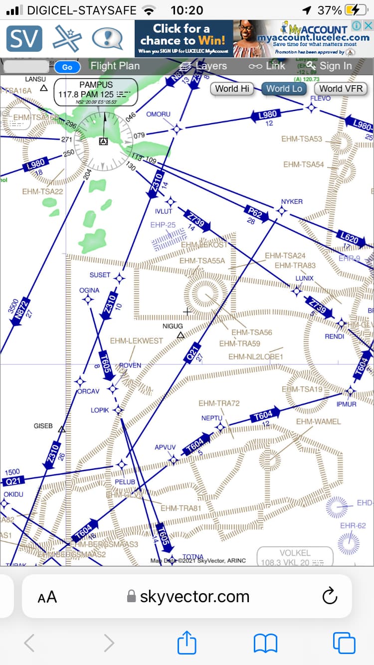
Let me take you to a simple route as an example. First you will need to open an account a simple and fast process (free).
Then select which type of map you want to use (VFR or IFR low or high). Let’s say that for this exercise you select World Low (click on the box on the upper right corner of the screen).
Click on FLIGHTPLAN (upper left corner of the screen). In the departure box type EDDH (Hamburg - Germany.) and in the destination box ENVA (Trondheim - Norway).
A magenta line appears. Zoom in until you clearly see the first possible waypoint out of EDDH and locate ABGEB on the map, pull your magenta line on ABGEB, continue North and locate ALSIE (that happens to be on the magenta line, right click on it and your route will automatically also insert EKERN (between ABGEB and ALSIE (notice that your routing is automatically updated in the FLIGHTPLAN window upper left), follow your magenta line going North and locate AALBORG VOR, pull your magenta line on it and right click, select VOR, again all previous waypoints will be automatically inserted, up North again locate near your line NEDZA, pull the line, right click, further North still close to your line, locate UTUNA, pull, right click and observe the route between NEDZA and UTUNA being updated,
In your FLIGHTPLAN window, your FlightPlan will now read: EDDH ABGEB M852 ALS P615 NEDZA P601 UTUNA ENVA. Copy and paste in Simbrief, transfer to MSFS, within MSFS click on LOAD and SAVE, find your EDDH-ENVA FlightPlan, load and you are ready to go.
Honestly automation does a lot of the work. I use ForeFlight, and when you put in a departure and a destination it gives you suggested routes. Some pilots fly everything direct, I find that to be just lazy and not the most efficient or safe way to plan. Basically it depends on the capabilities of your aircraft, the weather, the terrain you’re flying over. If you give me a few example trips I’ll tell you what I’d do.
Flight planning consists of three big theoretical subjects, General Navigation, Radio Navigation and Flight Planning & Monitoring. Its not easy, usually during VFR flight planning you would learn the basics. How to use a map, measuring tracks and distances, use if aircraft performance tables using the flight computer to calculate heading and groundspeed using the forecasted wind, take-off and landing performance, weight and balance.
When I was an instructor we used to let the student do all of this by hand on paper. Once they moved on to IFR they would understand the basics and it would be a waste of time to do everything by hand, so the students were using a excel planning tool (link below) which did the “stupid work”.
The student only has focus on specific IFR planning techniques and type this into the excel which then did the rest. Skyvector is a useful tool to crosscheck the route but its not all that useful in creating the route itself (talking about real world flight planning). Best would be to use a Jeppesen or Navblue IFR en-route chart instead.
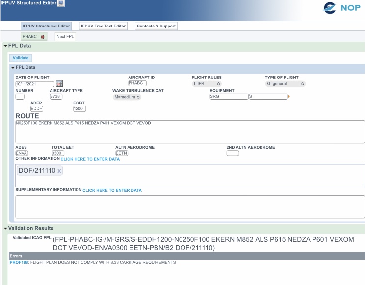
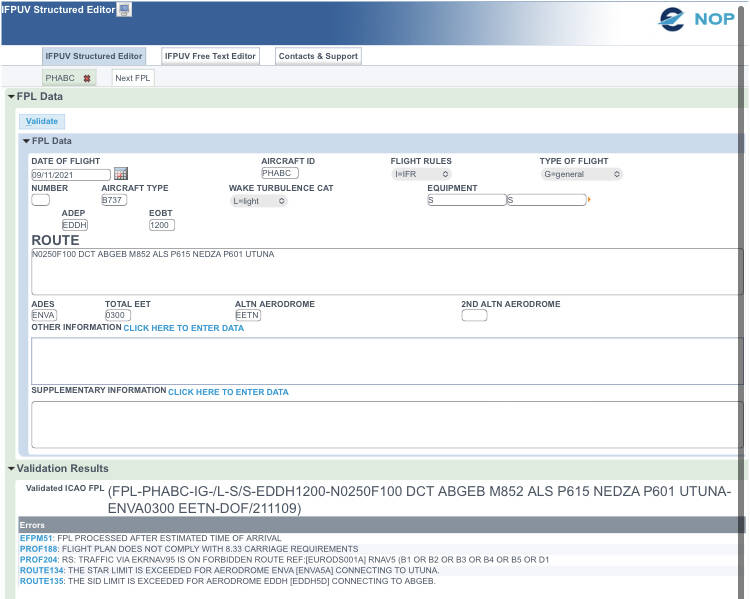
The route itself is fine, the first and last points however are invalid. I have flown both to Hamburg and Trondheim in the past don’t remember what the SID and STAR route points were but apparently these are invalid (errors are shown at the bottom):
Don’t look at the forbidden route error, I haven’t specified PBN in the editor.
Edit: Seems like the route should start from EKERN. You should at some point take one airway further east (Z320), terminating at point VEVOD or file a direct to connect with the STAR at Trondheim. Illustrating that just selecting some points in Skyvector which are more or less on the route won’t cut it in the real world.
The following would be a valid route for real world navigation:
EKERN M852 ALS P615 NEDZA P601 VEXOM DCT VEVOD