How is this approach to be flown? There’s something I’m missing here. It’s categorized as an ILS aproach, yet I get no glideslope, just the localizer. What am I doing wrong? Thanks in advance!

Follow the localizer, adjust your height and sinkrate to follow the altitude profile shown on the plate, use DME to get your distance. So essentially treat it like a VORDME approach.
Once you have visuals, you can refer to VASI / PAPI for correct glide slope.
1 Like
Oh ok! Thank you. Why is it rated as an ILS approach then? Is that standard practice?
I think MSFS and Navigraph/Jeppesen call this a LOC approach.
Edit: Checked in Navigraph, it says there is a GS and this is a regular ILS approach. Maybe MSFS has outdated data?
1 Like
The chart at the bottom is the side view of your descent path. I believe they have name the GS (glide slope) as GP (glide path) 3.0°.
The attached map doesn’t even show the ICAO that should be ENSB, On Little Nav Map you can check the ILS data .
1 Like
You need to enter course 097, (not the heading-although RPs put in both so if you have to revert to HDG navigation it’s in correctly) you need to put in Nav 1 Frequency as=110.30, your glideslope is 3.0 and the way points are at the bottom of the chart. It’s a bad representation of an ILS Approach Plate (current term for them). Lots of other data on them as well. See a YouTube video on how to read one, it will help you.
None of this answers the actual question.
Because a Localizer only approach is an ILS, It’s providing Lateral Guidance, with a DME to give the plane hard step down altitudes at specific distances during each waypoint until runway threshold. Not all ILS provide vertical guidance, there’s many reasons, including space for the equipment, potential obstructions that would force a greater than 3 degree GS, etc.
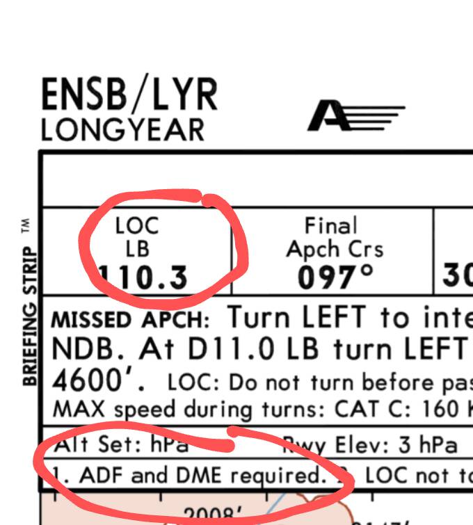
Looking at the Jepp plate for this approach - it’s a LOC only - note this section in the Approach Briefing Information Strip.
Localizer only frequency, and ADF/DME required.
1 Like
Then why does the plate mention different DAs for “ILS” and “LOC (GS out)”?
1 Like
Thanks for the reply. Very interesting indeed. I guess, what threw me off, is that there exist localizer approaches, specifically, so I didn’t see why it would be marked as an ILS app, and to make matters more confusing, the plate you posted describes it as a localizer approach.
There’s now a secondary problem I encountered. The DME seems separated from the localizer, and kinda tied to the NDB. How do I enter the DME frequency from the plate into my G1000nxi? How do I need to interpret the number on the plate? Specifically, I’m talking about the “Ch40x LB” DME. I’ve seen these types of numbers on some NDB/DME approaches, but I have no clue what it means and how to use it inside my G1000nxi. What do these numbers mean?
Thank you for your help!
It’s still sort of a mystery to me, lol. CasualClick showed it as a Loc approach as well. I wonder what the heck is going on with that approach.
Because, as you said, if I have to fly the glideslope manually without vertical reference, would it then technically not be a non-precision approach, hence not ILS by definition? Correct me please where wrong.
1 Like
I’m happy to report I was wrong - because I decided the proof was in the pudding and flew the approach manually. ![]()
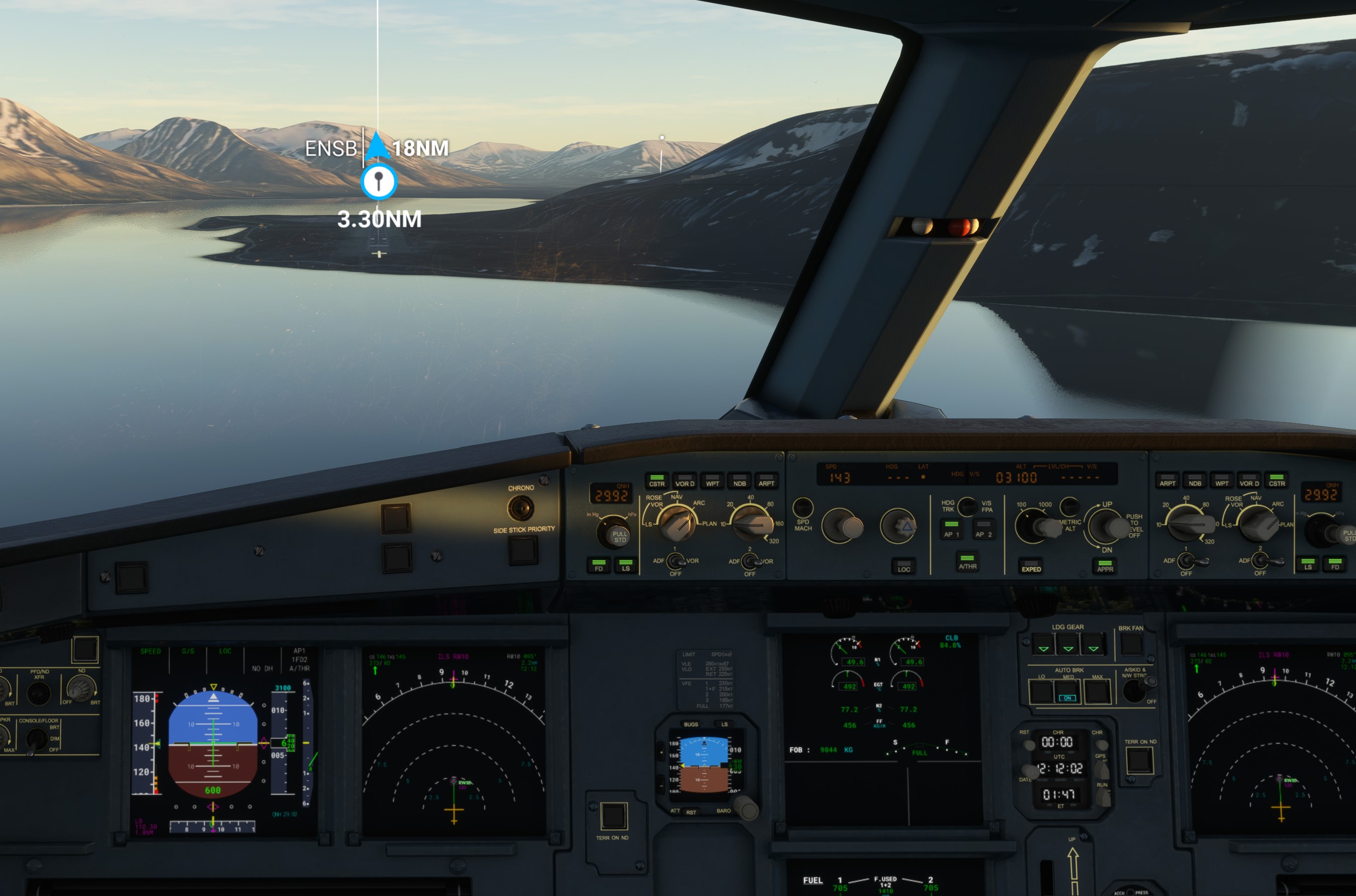
Set up in the air, flew the IF LALAD to LOLVO then turned to ENSB. I had 110.3 already dialed into NAV1. Runway 10 is an ILS with GS approach. At about 9.5NM (I didn’t have ADF/DME tuned, I just used the GPS readout in the Annunciator Scorecard), the GS kicked in.
RWY 28 is definitely a LOC only because it’s off-set by 16 degrees. But RWY 10 is not.
PAPI will show you high in-close, so fly the needles!


.
3 Likes
Thanks for doing the field research! Out of curiosity, are you using Navigraph or stock MSFS navdata?
1 Like
I am on Navigraph. So your mileage my vary. Inside the US, stock Navblue is comparable to Navigraph with the FAA supplements applied for each AIRAC Cycle. Outside the US, you may find Navigraph more current.
1 Like
Today I wanted to take a long flight with Asobo A320 to check if I was going to have fps drop like many have complained about .So I decided to make a flight plan from ENAN to ENSB .
From worldmap started from ENAN RW 32 , Departure : direct , Arrival : direct , Approach : ILS 10
About 2 hrs flight, no fps drops , good ILS landing with with LOC/GS engaged
.
1 Like
Much appreciated, this clears it up a lot!! Thanks Any word on that DME number as seen on the plate? It’s a separate topic, but I thought I’d ask nonetheless.
What “DME Number” do you mean? If you tune in the ILS, the DME will automatically also be tuned in (their frequencies are coupled / at a fixed offset, as far as I understand it).
2 Likes
What is this, and what does it stand for? I’ve seen it on other approaches as well.
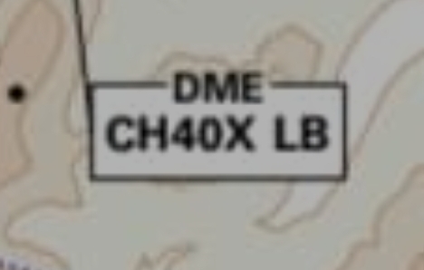
It’s the DME channel but there’s no in flight use for that information, all you do is tune the ILS and the DME will be tuned with it.
1 Like
looks like a Tacan Channel 40X but without azimuth information. As DashQuickly said there is no use for us, this is for military aircraft with Tacan receivers
1 Like