Pee-Wee says: Part Three…Activate! ![]()
![]() Big River, Medium Size Missiles: The Sagua La Grande MRBM Sites
Big River, Medium Size Missiles: The Sagua La Grande MRBM Sites
Site #1
MSFS: 22.730 -80.030
Skyvector: 224348N0800148W
Site #2
MSFS: 22.656 -79.868
Skyvector: 223922N0795205W
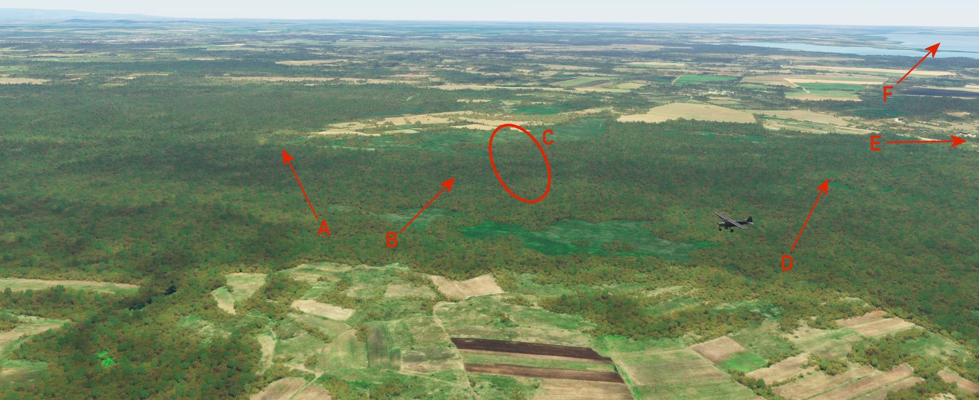
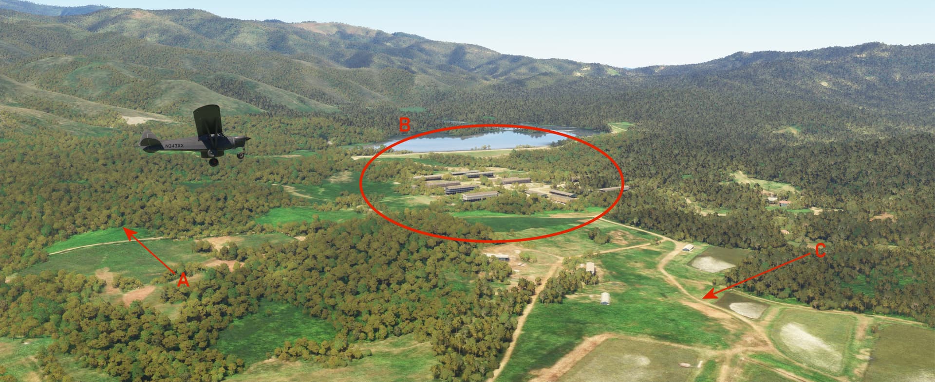
We’re now approximately 275 miles from where we started in San Julián and 160 miles east-southeast of Havana, in the central Cuban province of Villa Clara. The Soviets constructed two R-12 sites in the hills southeast of Sagua La Grande, a town named for the river it straddles. These two sites were occupied by the 29th Missile Division’s 79th Missile Regiment and were operational before the end of October 1962.
Pee-Wee says: That’s Site #1 down there, looking southwest. Honest!

Here we are passing over Site #2, looking northwest toward Site #1, ten miles distant. Much of the southern portion of this site has been claimed by a strip mine, but we were able to identify (A) the equipment and vehicle parking area, (B) the two completed launch pads, and (C) the warhead storage bunker. Several missile ready tents were positioned along the road just underneath our Monster’s left main landing gear. To the east there’s (D) an irrigation canal and railroad which should help you locate this site. El Purio lies in the distance (E).
Pee-Wee says: Despite their location further east than the San Cristobal sites, R-12s from the Sagua La Grande sites could still have delivered a multi-megaton warhead anywhere in the east-central United States within minutes.
![]() Close But No Cuban Cigar: The Remedios IRBM and Military Camp Sites
Close But No Cuban Cigar: The Remedios IRBM and Military Camp Sites
IRBM Site
MSFS: 22.418 -79.592
Skyvector: 222505N0793531W
Remedios Military Camp
MSFS: 22.425 -79.580
Skyvector: 222530N0793448W
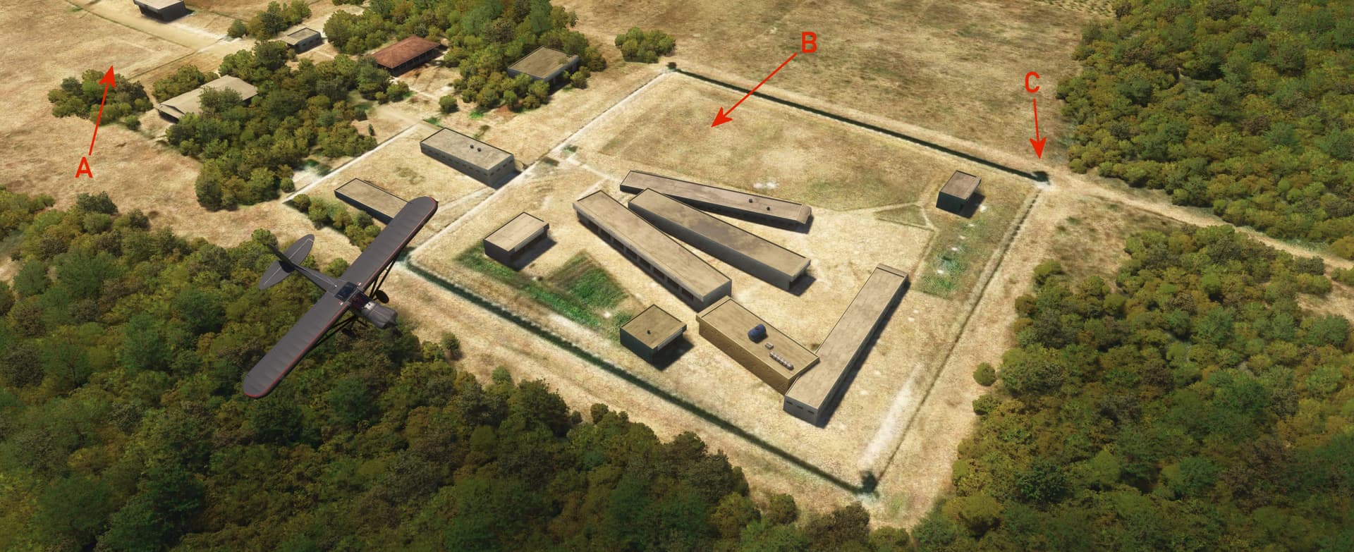
Construction of this IRBM site was never completed, and consequently very little remains to be seen from the air. The 43rd Missile Division’s 665th or 668th Missile Regiment would have encamped here with twelve R-14s, each carrying a one-megaton nuclear explosive, and while the warheads reached Cuba in October 1962, the missiles never arrived.

We’re flying east and looking northeast in this photo. (Pee-Wee: It took a few passes to find the site.
Pee-Wee says: You can also see: (A) the vehicle and tent encampment area, (B) a 57-mm anti-aircraft artillery battery, (C) a secure storage area (not the warhead bunker, which was located across the road from the launch pads), (D) the four launch pads, and (E) the concrete mixing site.
Based on the other sites, the CIA assumed that another launch site would be nearby, but it seems that construction never began, making Remedios the only “single site” missile location in Cuba.
![]() You Got Your Ears On, Fidel?: The Camaguey Military Camp and Air Base
You Got Your Ears On, Fidel?: The Camaguey Military Camp and Air Base
Camaguey Military Camp
MSFS: 21.351 -77.853
Skyvector: 212104N0775111W
Camaguey Air Base (MUCM)
MSFS: 21.420 -77.847
Skyvector: 212512N0775049W
The Soviets maintained six long-range early warning radar sites around Cuba. One was located south of Camaguey, and large portions of the site remain visible today. The leg here from the Remedios was one of our longest, spanning approximately 110 nautical miles.

We’re flying roughly southeast in this screenshot. The original (B) barracks and (C) motor park are visible, as are (A and D) the approximate locations of various radars. A (E) microwave communications antenna that linked this site to the other early warning radar sites stood here. In the distance is (F) Camaguey Air Base, from where the Soviet PVO’s 213th Aviation Regiment, 3rd Squadron operated Mig-21F-13 (NATO: Fishbed-C) day fighters, and the Cuban Revolutionary Air Force operated Mig-15bis (NATO: Fagot-B).
Established during World War 2, Camaguey Air Base once hosted Douglas B-18 Bolos of the USAAC’s 25th Bombardment Group, and later Mi-17s (NATO: Hip) of the Cuban Revolutionary Air Force’s 3685th Regiment. Today the base is the Ignacio Agramonte International Airport (MUCM) and is served by American Airlines, Nordwind, and several smaller Caribbean carriers.
During the Crisis the Cuban Air Force dispersed its 36 Mig-15s to airfields around the island to prevent their destruction by the Americans. They attempted intercepting the Crusaders and Voodoos that roared over the island daily but were wholly unsuccessful thanks to the slow transfer of information from the Soviet radar operators to the Cuban air bases. The intruding Americans were long gone before the Migs could even takeoff.
Pee-Wee says: Of the sites we explored, the Camaguey Military Camp is one of the few that has been clearly repurposed by the Cubans. The Villa Maraguán resort hotel occupies much of the camp’s barracks area and offers a swimming pool and a recreation area with running track and football field, all probably constructed by the Soviets in 1962. According to one online review, the hotel once boasted a small zoo, which probably wasn’t built by the Soviets. ![]()
![]() From Dvinas to Reclusos: Victora de Las Tunas SAM Assembly Site
From Dvinas to Reclusos: Victora de Las Tunas SAM Assembly Site
MSFS: 21.080 -77.006
Skyvector: 210448N0770022W
This site, one of several at which the Soviets assembled S-75 and S-125 missiles, appears mostly unchanged from 1962, with one notable exception: the new security fences are designed to keep people in!
Here we are passing low over the former SAM assembly site, heading east. Most of the structures remain unchanged from 1962, although there are some additions. You can clearly see the (A) guard’s and (B) prisoner’s baseball diamonds. It appears the Cubans have added a double fence around the secure portion of the prison, with (C) guard towers at each corner.
Pee-Wee says: We found no mention of this prison online. Openstreetmaps.org labels the site “Prision de Potosi,” but all other online sites we found place the Potosi Prison southwest of Las Tunas. We figure there’s several possibilities: this prison is closed and its name was reused elsewhere, the online information is missing or incorrect, or someone doesn’t want people to know this prison exists. We know the Cuban Government has a tendency to toss dissidents in prison, so…who knows? ![]()
![]() More Beagles and A Unique Deployment: Holguín Air Base (MUHG) and S-75 Site
More Beagles and A Unique Deployment: Holguín Air Base (MUHG) and S-75 Site
MSFS: 20.786 -76.315
Skyvector: 204710N0761854W
On 4 November 1962 crates carrying nine Il-28 Beagles were photographed at Holguín Air Base near Holguín in the former Oriente Province. The CIA believed the aircraft arrived aboard the Russian merchant ship Leninsky Komsomol on 20 October (Pee-Wee: Likely at either Nicaro or Santiago de Cuba.) Their presence brought the total number of Soviet medium bombers (airworthy or otherwise) in Cuba to 42. Photographic interpreters also noted the lengthened runway and covered aircraft revetments.
Today the air base is the Frank País Airport (MUHM) and is served by American Airlines, Condor, SunWings, VivaAerobús, and several other South American carriers. Airlines operate from a terminal on the southeast corner of the airfield, while the Cuban Air Force’s 34th Tactical Support Regiment operates Mig-23BNs (NATO: Flogger-H) from the opposite side of the runway.
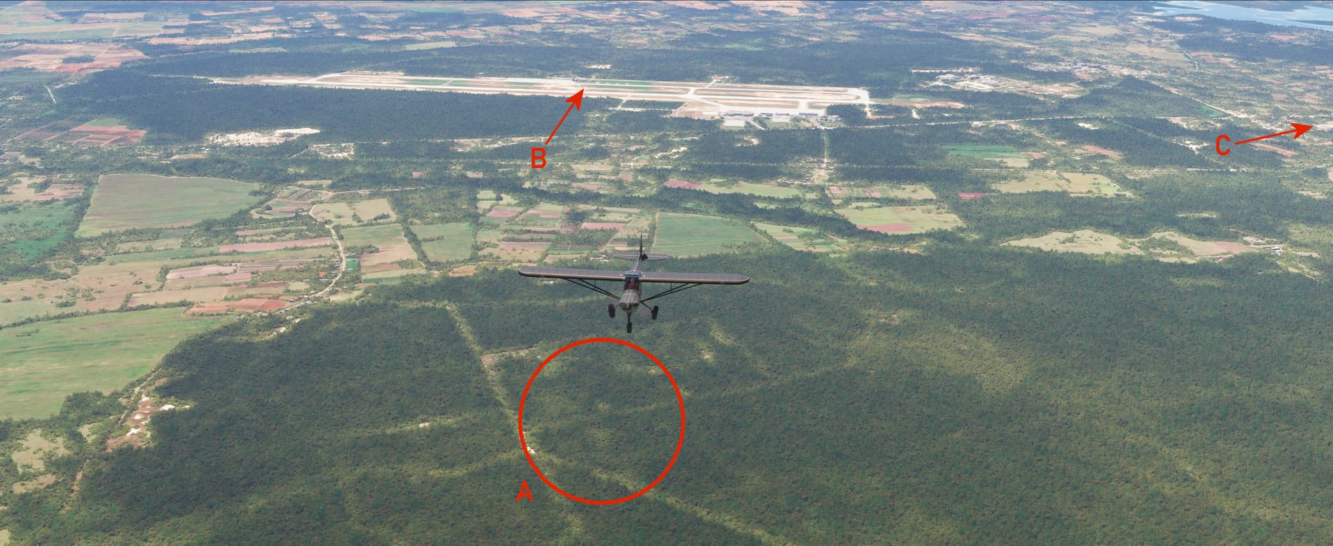
There’s not much to see in this screenshot, but that doesn’t mean it’s not interesting! Holguín Air Base/Frank País Airport (B) is visible in the distance, on the outskirts of (C) Holguín.
Pee-Wee says: (A) is the approximate location of a S-75 SAM site. We don’t know the precise location as this was one of very few field deployed (i.e. no permanent facilities) S-75/Fan Song sites in Cuba during the Crisis. The CIA’s information places the site somewhere among the old dirt roads visible surrounding (A). If anyone has solid information, we’d love to hear from you! ![]()
From here we turned east toward Banes on Cuba’s eastern shore. We’re going to talk about an airplane crash next, so feel free to skip ahead if you’d like. Otherwise, click on the blurred text to read on.
![]() Unintentional Escalation: The Shoot Down of U-2F 56-6676
Unintentional Escalation: The Shoot Down of U-2F 56-6676
MSFS: 20.967015 -75.749486
Skyvector: 205801N0754458W
27 October 1962 could have been a very bad day for the world. Acting in contradiction of First Secretary Khruschev’s orders, the Soviet SAM forces downed a 4080th Strategic Reconnaissance Wing U-2F flying near Banes. The aircraft, piloted by thirty-five-year-old Major Rudy Anderson of the 4028th Strategic Reconnaissance Weather Squadron at Laughlin AFB, Texas, was deployed to McCoy AFB near Orlando, Florida. Originally delivered to the CIA as Article 343, the aircraft was transferred to the USAF and designated 56-6676 (and that’s why we chose the registration N343XX for our Monster).
Pee-Wee says: It seems that local commanders were concerned that Anderson’s overflight would reveal the extent of the Soviet and Cuban offenses directed at the American’s naval base at Guantanamo Bay, including the presence of tactical nuclear weapons. Time was of the essence, and the overall Soviet commander was unavailable. Two Soviet generals made the decision to fire upon the intruder and passed the order to a S-75 site north of Banes.
The Soviets fired two missiles, one of which detonated close enough to the U-2 to pepper the aircraft with shrapnel. Major Anderson’s pressure suit was ruptured, and the sudden high-altitude decompression killed him almost instantly. The aircraft crashed just north of the village of Veguitas, one mile west of Banes. Thankfully President Kennedy defied his military advisors and elected to not retaliate, which could have led to the spiraling escalation of a situation that was rapidly slipping out of control.
Anderson’s body was found in the wreckage and returned to the United States on 4 November. He was laid to rest at the Woodlawn Memorial Park in Greenville, South Carolina two days later, and posthumously awarded the Air Force Cross.

Here we are flying roughly northwest near (C) Banes, the direction in which Major Anderson was flying when he was shot down by an S-75 fired from (B) a SAM site north of Banes. The wreckage landed (A) near a small village west of Banes.
Pee-Wee says: Major Anderson was survived by his wife, Jane, and two sons, Tripp and Jim. Jane was pregnant with their third child, a daughter named Robyn, at the time of Rudy’s death. She later remarried and birthed another daughter, Lydia Chaney. Jane passed away in 1981, aged 46, after battling a respiratory illness and is buried in Pearson, Georgia.
Pee-Wee also says: While Major Anderson was the only “combat” loss the Americans suffered during the Crisis, other airmen were killed in the line of duty. Eleven crewmen assigned to the 55th Strategic Reconnaissance Wing died in three separate RB-47 crashes while supporting American forces in the region, and seven airmen from McGuire AFB died when their C-135B crashed while landing at Guantanamo Bay on 23 October.
![]() A Nice Place to Vacation: The Mayari Arriba Military Camp
A Nice Place to Vacation: The Mayari Arriba Military Camp
MSFS: 20.452 -75.520
Skyvector: 202707N0753112W
Pee-Wee says: We originally intended to skip this site, as it doesn’t appear anything interesting happened here. But it was along the route, so we descended into the valley for a quick peek anyway, and we weren’t disappointed!
We’re flying roughly southeast in this screenshot, looking north. You can see (A) ammunition storage bunkers, hidden within the tree line, (B) the main camp, and (C) the open storage areas. Beyond the camp is Embalse Micarda, a reservoir constructed sometime between 1962 and 1985. Some CIA documents indicate that SAMs were also constructed here. Today the site is a Cuban Army special operations training camp.
![]() You Can’t Handle the Truth!: Guantanamo Bay Naval Base and Leeward Field (MUGM)
You Can’t Handle the Truth!: Guantanamo Bay Naval Base and Leeward Field (MUGM)
MSFS: 19.906 -75.206
Skyvector: 195422N0751222W
We’re in the home stretch now, with only one site remaining. We could write an entire post just about Guantanamo Bay, but instead, we’ll hit the high points.
Pee-Wee says: The United States and Cuba entered into a lease agreement for the land that is Naval Base Guantanamo Bay in 1903. The US agreed to pay the Cubans a meager annual sum for the 45 square miles of land. Even at the adjusted rate of $4,085 set in 1974, the US has paid Cuba less than $500,000 for the land, and the Cubans have only bothered to deposit one payment. That’s quite the bargain!
The US presence at Guantanamo Bay has been a thorn in the Cuban Government’s side since before the Revolution, and it routinely demands the return of the land. The lease has no expiration date, which means either both parties must agree to terminate the lease or the Navy must abandon the land.
Pee-Wee says: Which isn’t going happen. ![]()
During the Crisis, the Soviets and Cubans moved troops and tactical nuclear weapons near Guantanamo and would have struck the base had the US invaded. The families of servicemen stationed here were evacuated in October 1962 and returned in late December.
Guantanamo Bay–or GITMO as it’s more commonly known–gained notoriety in the 1992 film A Few Good Men starring Tom Cruise as the brash JAG lawyer Lieutenant Daniel Kaffee and Jack Nicholson as Colonel Nathan Jessep. None of the movie was filmed at GITMO.

In this screenshot, we’re on a high right base to Runway 10 at Leeward Field on the west side of Guantanamo Bay. You can see (A) the perimeter fence separating Cuba from the Naval Base, and (C) the former McCalla Field airstrip, now the site of the DOD’s controversial detainment camp. Most of the base’s facilities lie on the east side of the bay, including Marine Rifle Company Windward’s barracks, where the fictional Private Santiago was murdered.
![]() More crashes. Once again, click on the blurred text if you want to read about them.
More crashes. Once again, click on the blurred text if you want to read about them.
Pee-Wee says: (B) marks the approximate crash site of both Air Force C-135B 62-4136 on 23 October 1962 and Kalitta DC-8-61 N814CK on 18 August 1993. Aircraft landing on Runway 10 must fly inside the (A) border fence, which requires a tight right turn at low altitude and airspeed. The NTSB determined that the Kalitta DC-8 overshot the final turn and entered an accelerated stall. The same thing may have happened to the C-135. The Kalitta crash was attributed to fatigue while the Air Force crash was likely caused by the crew’s inexperience (their C-135 had been delivered only a few months prior to the accident).
We’ve reached the end of our longest tour ever! Our total flight time, including a few search patterns and orbits over those hard-to-find missile sites, was just over six hours. We burned through two tanks of 100 Low Lead, countless potato chips, and a whole block of Pee-Wee’s homemade peanut butter fudge.
Pee-Wee says: And probably about ten gallons of water. Do you think the Marines have a latrine? ![]()
There’s lots of information about the Crisis online, especially in the CIA’s Freedom of Information Act Reading Room. We can also highly recommend One Minute to Midnight by Michael Dobbs. Be careful with online sources, especially Marshall University’s online photo collection: many of the photos are mislabeled and otherwise incorrectly captioned. You’ll need to don your sleuthing caps!
Thanks for tuning in, everyone! We’ll be back in a few days for a very special “historical” flight. Fly safe!
Pee-Wee says: Bye for now! ![]()
The Cuban Missile/Caribbean/October Crisis effectively ended in December 1962 when the Soviet troops and their missiles left the island under observation by the Americans. Several months later, the US removed its nuclear-tipped Jupiter MRBMs from Turkey. With the fate of millions hinging on subtle inferences and poor assumptions by both sides, a telephone hotline–the “Red Phone”–that would allow for rapid and direct communications between the American and Russian leaders was installed.
To the World, it appeared that the Soviets “lost” the battle, and First Secretary Khruschev was ousted in 1964. President Kennedy was assassinated in Dallas in November 1963, barely one year after the Crisis abated. Fidel Castro remained in power in Cuba until his death in November 2016.
The United States and Soviet Union entered into a nuclear test ban treaty in 1963, the first such treaty that limited nuclear proliferation and moved the World away from nuclear disaster.
The United States’ and Soviet Union’s proxy war in Vietnam claimed the lives of nearly 1.4 million Americans, Soviets, and North and South Vietnamese. South Vietnam collapsed in 1975, a nominal victory for the Soviets.
The first of the Americans’ new Minuteman I missiles went on alert at the height of the Crisis on 27 October 1962. The Soviet Union detonated the largest nuclear bomb on record–the 50-megaton Tsar Bomb–three days later over Novaya Zemlya.
The United States currently maintains 400 Minuteman III ICBMs and fourteen nuclear ballistic missile submarines with [Trident] nuclear(Trident (missile) - Wikipedia) missiles. The American nuclear bomber fleet has been all but retired, and currently consists of twenty B-2 Spirit stealth bombers and a dwindling number of B-52H Stratofortresses. The supersonic B-1 Lancer surrendered its nuclear role in 1995. Most Air Force and Navy tactical fighters are capable of delivering tactical nuclear weapons with published yields up to approximately 400 kilotons, more than twenty times the explosive forces of Little Boy and Fat Man.
The Soviet Union imploded spectacularly in late 1991. The current Russian nuclear force consists of missiles of varying capabilities and ranges, the Tu-95 (NATO: Bear) and Tu-160 (NATO: Blackjack) bombers and, nuclear ballistic missile submarines. The reported number of Russian warheads and delivery platforms varies wildly depending on the source. Regardless, the Russian nuclear force remains formidable.
Cuba remains a pariah in the Caribbean. Thousands of people sought refuge in the United States during the Mariel Boat Lift in the early 1980s, and hundreds more are found aboard makeshift rafts in the Florida Straits by the United States Coast Guard every year. Only those who actually land in the US are allowed to stay. The others are provided with food, water, and medical care before being returned to Cuba. The number of those killed every year trying to reach freedom in the US is unknown. Today the Cuban diaspora in Miami numbers in the millions.
The Cuban Air Force is the largest in the Caribbean, although the serviceability of its fleet of antiquated Soviet aircraft is questionable. Most of the island’s air defense is provided by ageing S-75s and S-125s, although a smaller number of other SAM systems including the potent 2K12 Kub (NATO: SA-6 Gainful) are now in service. Cuban men are still required to spend two years in “active military service,” and it appears some are currently fighting in Ukraine.
The 55th Strategic Wing remains active with a fleet of signal gathering EC and RC-135s at Offutt AFB, Nebraska. The similarly equipped B-47s were retired in 1967.
The Navy’s and Marine Corps’ Photo Crusaders bowed out in 1984, the “Last of the Last of the Gunfighters.” VFP-62 served in Vietnam but was disestablished in 1968, handing its mission and aircraft to sister squadron VFP-63 and the RA-5C Vigilante’s of the Navy’s RVAH squadrons.
The 363d Tactical Reconnaissance Wing surrendered its Voodoos for RF-4 Phantoms before transitioning to a combat role in the early 1980s. The Wing’s F-16 Fighting Falcons flew combat missions over Iraq in 1991 and 2001. In 2015 the unit returned to the reconnaissance role as the 363rd Intelligence, Surveillance and Reconnaissance Wing, stationed at Joint Base Langley-Eustice in Virginia.
The U-2 continues in service with the US Air Force’s 9th Reconnaissance Wing at Beale AFB, California. There are no plans to retire the 31 remaining aircraft.
The CIA’s aerial and satellite intelligence gathering operations remain classified.
Pee-Wee says: To all veterans regardless of the flag on their uniform, to their families, and especially to those lost in the pursuit of freedom during war and peace, thank you. ![]()