P&N Over the Cotentin (Cherbourg) Peninsula: Part 1
(Hey, look! I figured out how to make headings! ![]() )
)
Pee-Wee says: Hello, guys and gals! We’re back…well, I’m back. Nag is still studying for his annual recurrent training and then heading out the door, so I’m flying solo today. Normally, my parts are italicized, but since I’m by myself, I’ll dispense with that formatting.
By the way, thanks to everyone who offered kind feedback about the Mission Boston writeup. I’m not going to lie: I thrive on positive reinforcement! Extra special thanks to forum user @MaverickKing57 for going above and beyond! Check out his new YouTube channel Fly to the Past for some excellent videos and, while you’re there, please like and subscribe to encourage an up-and-coming creator.
Today’s multi-part tour covers sites related to the Allied invasion of the Cotentin Peninsula in June 1944, from Cherbourg in the north to Carentan and the Douve River in the south. I originally thought about flying my favorite Tiger Moth for this tour but elected instead to stick with our new custom 7-10 Split as seen in our Mission Boston writeup. (Thanks again to jamespejam at flightsim.to for the skins and for converting his masterpiece to fit the new AH C-47. You’re a doll, T.O.! ![]() )
)
![]() Cherbourg–Maupertus Airport (LFRC)
Cherbourg–Maupertus Airport (LFRC)
MSFS: 49.650 -1.470
Skyvector: 493900N0012811W
Scenery by: YvesP6 @ flightsim.to
I started and ended at Cherbourg–Maupertus Airport (LFRC), making this tour one of few in which the departure airport is also one of the historic sites!
Originally named Maupertus-sur-Mer, the airfield apparently hosted Armée de l’air fighters (possibly Bloch MB.151s or 152s) until occupied by the Luftwaffe. The “Stukas” of Sturzkampfgeschwader (“Dive Bombing Squadron”) 2 arrived in July 1940 and wrought havoc on Allied shipping in the English Channel before turning its attention to the English mainland during the Battle of Britain. The unit left Maupertus by August.
The Americans captured the airfield on 27 June 1944 after a week of fighting, and by 4 July the 850th and 877th Engineer Aviation Battalions had returned the airfield to service as Advanced Landing Ground 15 (ALG-15). Over the next few months three units were stationed here: the 363rd Fighter Group, the 422nd Night Fighter Squadron, and the 387th Bombardment Group (Medium). Once these combat units moved east to follow the advancing Allies, Maupertus served primarily as a casualty evacuation station.
After the war, the French expanded the airport’s civil facilities and replaced the original runway with a sturdier 8,000-foot (2,438-meter) concrete strip. Paved revetments intended for use by NATO aircraft were added to the northeast portion of the field but were never used.
Today the airport serves as a civil field. There is no commercial airline service at Cherbourg, but the Aéronavale’s 32F maintains a search-and-rescue (SAR) detachment of Airbus H-160 helicopters here.
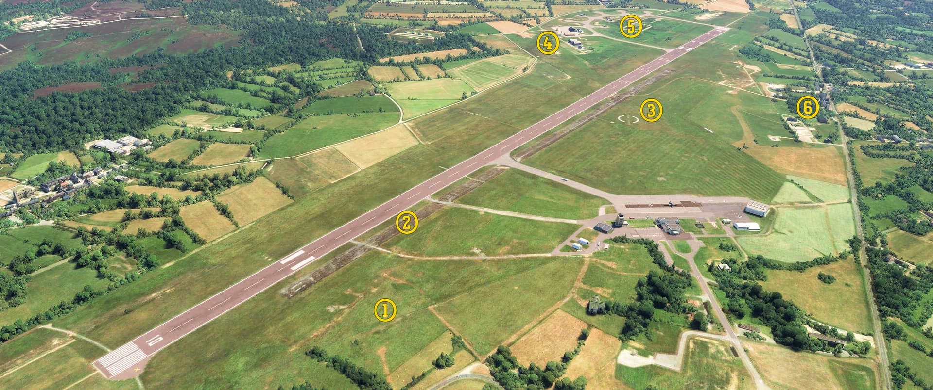
We’re looking northeast in this photo. You can see: (1) former revetments and taxiways dating to World War II, (2) the original Runway 11/29, (3) the midfield “Maupertus” marking, (4) the Aéronavale SAR detachment’s facilities, (5) the “NATO revetments,” and (6) several German bunkers and other structures dating from World War 2.
![]() V-1 Launch Site #17 “Mesnil-au-Val”
V-1 Launch Site #17 “Mesnil-au-Val”
MSFS: 49.581490 -1.543261
Skyvector: 493453N0013236W
Several launch sites for Germany’s Vengeance Weapons were under construction when the Allies invaded in June 1944. One of the best preserved is permanent V-1 Launch Site 17 approximately five miles (8 kilometers) south of Cherbourg. “Buzz Bombs” launched from here would have targeted Bristol.
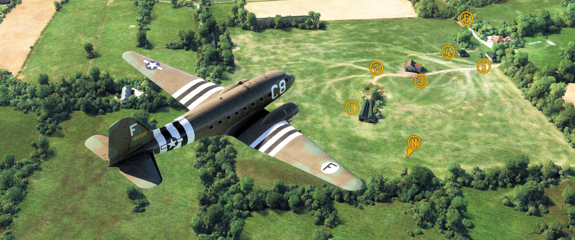
There’s V-1 Site #17 down there in a farmer’s field. I’ve marked (1) the launch ramp and protective concrete walls, which appear as triangular-shaped buildings in MSFS, (2) the original road over which V-1s would have been moved to the launch ramp, (3) the “anti-magnetic” building where the weapons’ gyros would have been calibrated before flight, (4) the compressor building, (5) the steam generator building, and (6) the assembly workshop. This site’s concrete walls protecting the launch ramp were unique.
![]() V-2 Launch and Storage Site “Reservelager West”
V-2 Launch and Storage Site “Reservelager West”
MSFS: 49.537708 -1.582485
Skyvector: 493216N0013457W
One of the largest facilities of its kind, the Reservelager West V-2 launch and storage site near Sottevast was a massive L-shaped construct, 300 feet long, 250 feet wide, and 90 feet tall (91 x 76 x 28 meters) with walls up to 12 feet (4 meters) thick, and capable of storing between 95 and 300 V-2 rockets (this number varies wildly between sources). Having become aware of the site’s significance, the Allies began routinely bombing Reservelager West from August 1943. By the time the 79th Infantry Division captured the site shortly after D-Day, all construction was halted, and the site abandoned. After being viewed by Generals Eisenhower and Bradley, American engineers buried the site.

Some portions of this massive V-2 facility are still visible today on a dairy farm about seven miles (11 kilometers) south of Cherbourg, including (1) the L-shaped bunker, now used for storing farm equipment, and (2) an associated bunker. Modern farm buildings southeast of the site are built upon a (3) concrete pad that may have been part of the V-2 site.
![]() [Museum Hangar à Dirigeables d’Écausseville
[Museum Hangar à Dirigeables d’Écausseville
MSFS: 49.451482 -1.381754
Skyvector: 492705N0012254W
Scenery by Greenhopper @ flightsim.to (original doors), or flightsim.to (current configuration)
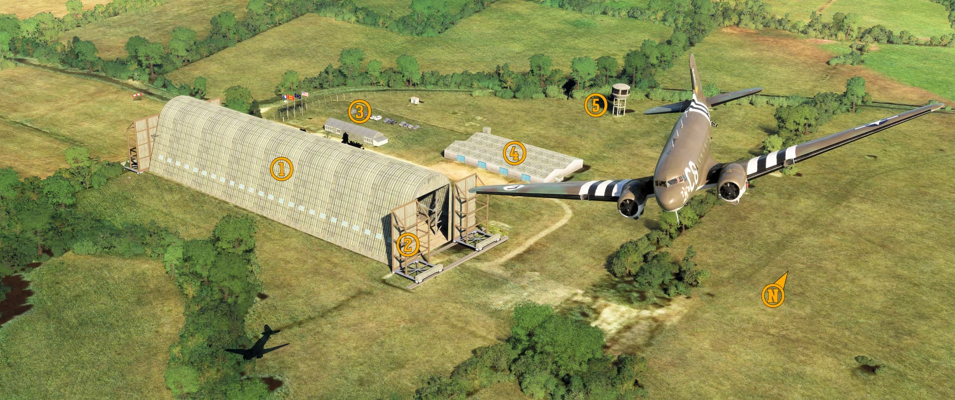
Yay! A blimp hangar! ![]() This is the Hangar à Dirigeables near Bazirerie in Écausseville. The original wooden hangar built during World War 1 no longer exists, but the 500-foot (150-meter) long concrete shed completed in 1919 remains. The wooden hangar was dismantled in 1932, and the French Navy shut down its airship program in 1936.
This is the Hangar à Dirigeables near Bazirerie in Écausseville. The original wooden hangar built during World War 1 no longer exists, but the 500-foot (150-meter) long concrete shed completed in 1919 remains. The wooden hangar was dismantled in 1932, and the French Navy shut down its airship program in 1936.
The French and the German occupiers subsequently used the concrete hangar for outsized equipment storage, including several 155-milimeter canons destined for installation at fixed gun batteries elsewhere on the Cotentin Peninsula. Having captured the facility intact, the Americans used it first as a prisoner of war camp and then for storing equipment, including trucks, fuel, and tires.
After the war the Direction des Applications Militaires / Commissariat à l’Énergie Atomique (DAMCEA, or “Directorate of Military Applications / Central Commission of Atomic Energy”) used the huge shed to develop aerostats for use in the French nuclear weapon testing program.
A protected national monument since 2003, the hangar survives today as a museum, and saw roughly 22,000 visitors in 2023.
I really don’t know why I have such a thing for blimp hangars. I’ll ask my therapist.
Greenhopper’s excellent scenery comes in two versions: the one seen here with the original hangar doors intact and a contemporary version with the building permanently sealed at both ends.
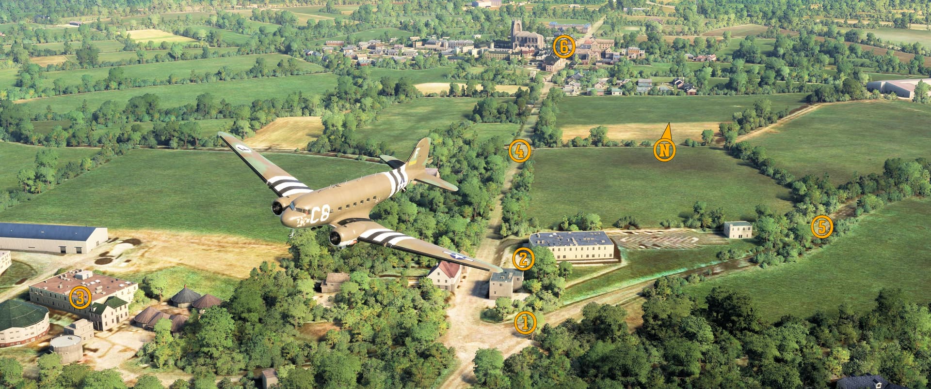
![]() Advanced Landing Ground 6 (ALG-6) / Beuzeville Airfield
Advanced Landing Ground 6 (ALG-6) / Beuzeville Airfield
MSFS: 49.420 -1.297
Skyvector: 492512N0011751W
The Allies constructed twenty-nine temporary Advanced Landing Ground airfields on the Cotentin Peninsula after D-Day. ALG-6 was located immediately east-northeast of Sainte-Mère-Église and served the 371st and 367th Fighter Groups. Several dramatic pictures are available online showing Waco gliders landing here on 11 June 1944 and C-47s dropping supplies the following day.
Today nothing remains of this important airfield, the first on the Allied beachhead on the Cotentin Peninsula. A memorial stands alongside the roadway that bounded the airfield to the west.
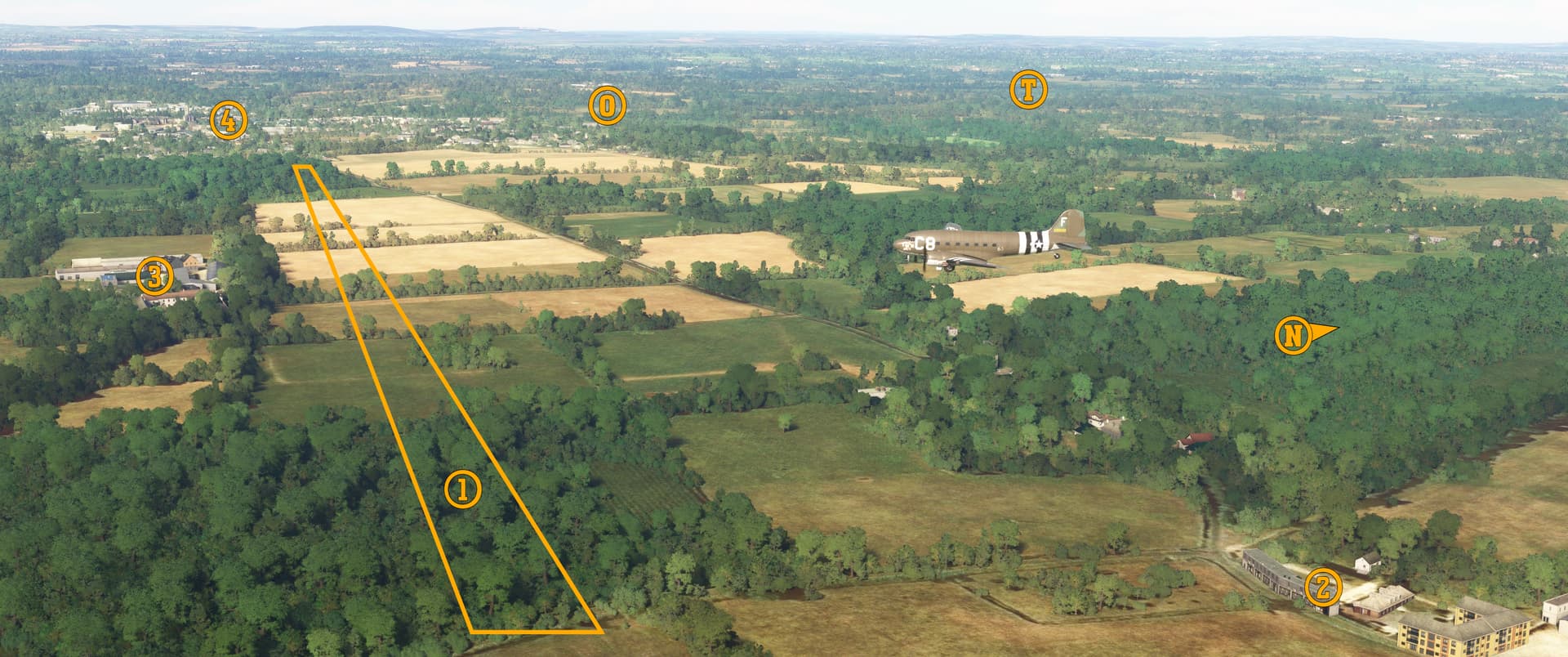
Here I am flying south over the former ALG-6. You can see: (1) the approximate outline of the former 5,000 foot (1,520 meter) runway, (2) Manoir d’Artilly, once home to famed horse breeder Jean-Yves Lécuyer, (3) Gaec de la Londe à Sainte Mère l’Eglise, a modern farm that stands atop former aircraft revetments, (4) the town of Sainte-Mère-Église (literally “Holy Mother’s Church”), and 82nd Airborne drop zones (O) and (T).
Incidentally, the road intersection where 1st Lieutenant Winters assisted in the ambush of some German supply wagons (as depicted in the miniseries Band of Brothers, Episode 2 “Day of Days”) is just outside the lower left corner of this screenshot.
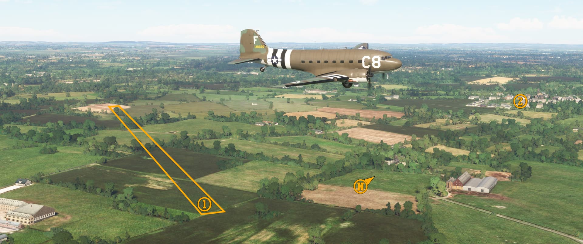
![]() Dead Man’s Corner / D-Day Experience Museum
Dead Man’s Corner / D-Day Experience Museum
MSFS: 49.328477 -1.268424
Skyvector: 491943N0011606W
Next, I flew south to Saint-Côme-du-Mont about 2.5 miles (4 kilometers) north of Carentan. Just south of the small town lies the intersection of D974, part of the throughfare connecting Paris and Cherbourg, and D913, the southernmost road connecting Utah Beach with D974. A German regimental headquarters and aide station occupied the house overlooking this intersection.
On 7 June 1944, a Stuart light tank of 3rd Platoon, Dog Company, 70th Tank Battalion was knocked out by a German anti-tank weapon at this intersection, killing three of its four enlisted crewmen. Because of the Americans’ rapid advance, the tank and its deceased crew remained at the intersection for several days, and “the intersection with the tank with the dead man inside” became an unfortunate landmark for Allied forces moving around the southern Cherbourg Peninsula. The name “Dead Man’s Corner” eventually stuck.
Today the D-Day Experience Museum occupies the house overlooking the intersection and a newly constructed building on the same property. Two Stuart tanks stand on the museum grounds.
There’s a wonderful and fascinating writeup at the Warfare History Network that delves into greater detail about the identity of the tank’s hapless crew and provides a masterclass in researching fallen soldiers’ identities.
Here I am flying roughly southwest over Dead Man’s Corner. I’ve marked: (1) the exact location where the Stuart light tank stood after being hit, (2) the D-Day Experience Museum, with 7-10 Split’s left wingtip touching the original house/headquarters, (3) what appears to be a French chateau but in reality is Carentan’s wastewater treatment plant, (4) road D974, (5) road D913, and (6) Saint-Côme-du-Mont.
![]() Carentan and the Douve River
Carentan and the Douve River
MSFS: 49.322 -1.255
Skyvector: 491919N0011521W
Allied planners determined that the rapid seizure of Carentan, the largest city in the southern Cherbourg Peninsula, was critical to Operation Overlord’s success, and assigned the task to the 101st Airborne Division. The Germans realized the importance of Carentan, too, and accordingly flooded the northern approaches to the town through which the Douve River flowed, hoping to stall the Allied advance. Their plan failed spectacularly: the Americans were able to move almost unimpeded across the open roadways toward Carentan while German reinforcements were severely hampered by the flooding. (I believe “fehlschlagen” is the German approximation of the English verb “backfire.”)

I’ve turned east in this screenshot, and you can see (1) the Douve River, (2) two of the bridges crossing the river (the D947 bridge over which the American 502nd PIR advanced is on the right), and (3) Carentan.
![]() Advanced Landing Ground 16 “Brucheville”
Advanced Landing Ground 16 “Brucheville”
MSFS: 49.368 -1.216
Skyvector: 492205N0011258W
The 843rd Air Engineer Battalion began construction of this Advanced Landing Ground south of Sainte-Marie-du-Mont in the morning of 6 July 1944, and the 36th Fighter Group’s first razorback P-47 Thunderbolts arrived the following day.
ALG-16’s runway was approximately 3,500 feet (1,067 meters) long and was surrounded by taxiways and aircraft revetments, with an ammunition dump to the southwest. The 36th FG departed in August and the field was mostly abandoned. Today, a memorial stone dedicated to the 36th Fighter Group stands near the runway’s southwestern end alongside road D424E1.
Nothing remains of the ALG-16 today. In this screenshot, I’ve marked (1) the approximate position of the runway and (2) Sainte-Marie-du-Mont.
![]() The Guns of Brécourt Manor
The Guns of Brécourt Manor
MSFS: 49.389 -1.226
Skyvector: 492323N0011337W
Brécourt Manor lies just north of Sainte-Marie-du-Mont between roads D14 and D424. A livestock farm, the Manor became famous after the 6 June 1944 assault on German artillery positioned there by elements of the 506th Parachute Infantry Regiment under the command of then 1st Lieutenant Dick Winters, executive officer of Easy Company, 3/506th PIR. The textbook assault is recreated in amazing accuracy in Episode 2 of HBO’s mini-series Band of Brothers.
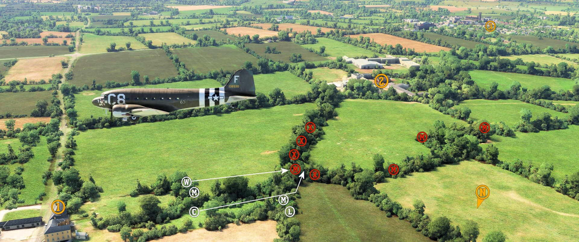
The Manor and the field in which the assault occurred are clearly visible in MSFS, and in this screenshot, I’ve marked (X) the approximate locations of the four 105-mm cannons, three of which were firing onto Causeway 2 leading off Utah Beach approximately three miles (five kilometers) to the southeast. The red (M’s) show the positions of the Germans’ defensive MG42 machine gun emplacements; the white (M’s) are the Americans’ two M1919 machine gun positions. Under covering fire from (L) Sgt. Lipton and the two machine guns, (C) 2nd Lieutenant Compton led a flank attack against the closest MG42 position. Once the German machine gun was silenced, (W) Lt. Winters and the main assault team ran from cover into the German trenches and disabled the cannons. You can also see (1) Easy Company’s temporary headquarters on road D14, (2) Brécourt Manor, and (3) Sainte-Marie-du-Mont.
Young Michel de Vallavieille, son of Brécourt Manor’s owner, was wounded during the assault and was evacuated to a hospital in England. He survived his wounds, returned to France, and eventually became the mayor of Sainte-Marie-du-Mont.
![]() Utah Beach
Utah Beach
MSFS: 49.415 -1.174
Skyvector: 492457N0011028W
Here I am flying north over Utah Beach, where the 4th Infantry Division and 70th Tank Battalion landed early on 6 June 1944. The Germans used dams and floodgates along the Douve and Vire Rivers to flood much of the farmland beyond the beach, leaving only several causeways as the only means for the Americans to advance inland. The task of clearing these causeways was assigned to the 101st Airborne Division.
Immediately before the landings, naval artillery and bombing by Ninth Air Force B-26s all but neutralized the German 709th Static Infantry Division defending Utah, and the statistics bear that out: of the 4th ID’s 21,000 men who landed at Utah, only 197 were killed (compared to approximately 2,400 casualties at Omaha Beach).
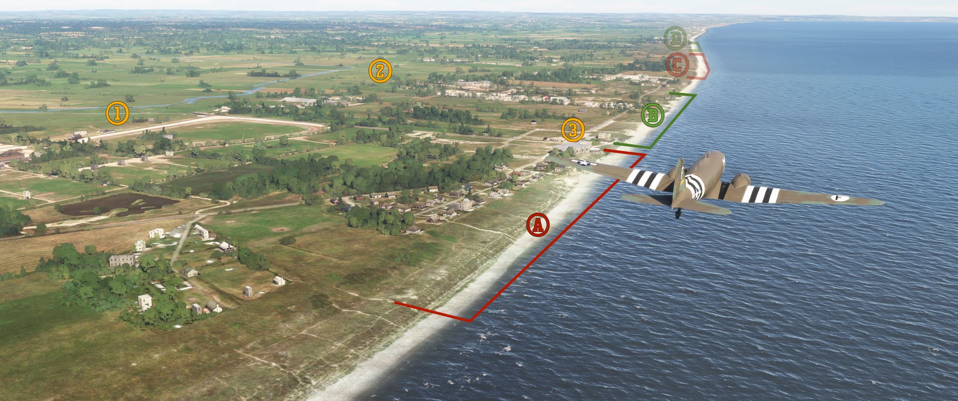
In this screenshot you can see (1) Causeway 2, road D913 to Sainte-Marie-du-Mont, (2) Causeway 3, road D67 to Sainte-Mère-Église, and (3) the Utah Beach Museum. The Americans planned to land at (C) Uncle Red and (D) Tare Green beaches but were pushed further south by strong currents and instead landed at (A) and (B). It was on this unplanned beachhead that General Theodore Roosevelt, Jr. said “we’ll start the war from right here!”
There’s a few more locations to spot, so stay tuned for the next installment coming very soon! ![]()