TV and communications towers are currently represented as oversized high-rise buildings. Because of their great height and their usually exposed locations, this sight is very annoying.
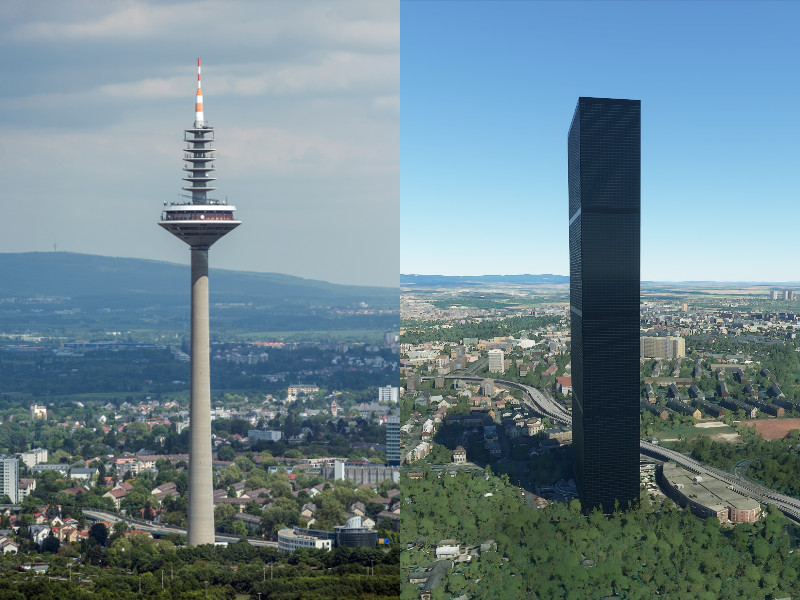
As an example, look at these pictures of the famous Frankfurt Europaturm:
To be clear: I don’t require a handcrafted model of this individual tower, but a generic model for all TV and communication towers. Or perhaps a bunch of generic communication tower models for different tower heights.
The metadata can be used to differentiate between towers and other high-rise buildings and the appropriate model can be visualized. Look at Frankfurt:
The Europaturm is tagged as a “communications_tower” and “communication” as tower type in OpenStreetMap.
The Messeturm, a commercial skyscraper, instead is tagged as a “commercial” building without a tower type in OpenStreetMap.
As a consequence, the Europaturm must be presented as a communication tower and the Messeturm as a high-rise building.
This should be the general procedure for all TV and communication towers in the world.
Feel free to post further examples!
Further Infos about Frankfurt Europaturm:
Bing map coordinates: 50,135299, 8,654633
I’ve noticed a lack of towers and obstructions in general. GA uses these a lot for VFR navigation as they are represented on sectional charts so in my opinion they are important for a touted “VFR” sim. There should be databases of these to pull from as a lot of aviation GPS devices have them loaded and displayed on maps.
I’m hoping perhaps it is in the works for the future. Like you a simple nice looking but generic tower representation with a flashing light would be great. Personally I’m going to wait a while to complain too much, post release and a lot of bugs to fix I’m sure there are more pressing things to work on for a while yet.
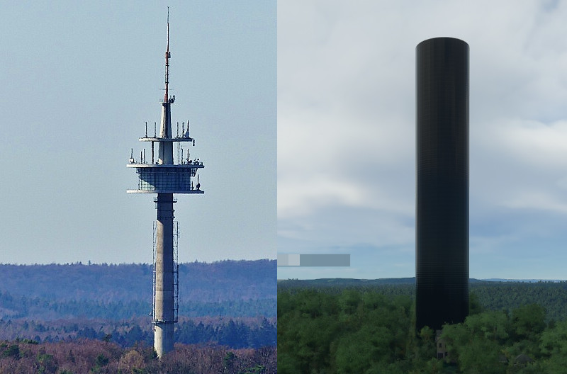
It is located south of Kaiserslautern and a landmark that can be seen from afar on the approach route to Ramstein airbase.
Again it is tagged as “communication” tower type in OpenStreetMap, therefore it should be possible to represent it as a generic communication tower model.
Further Infos about Fernmeldeturm Dansenberg:
Bing map coordinates: 49,412359, 7,740474
The missing TV- and communication towers seem to be a general problem in the AI implementation. Except a few handcrafted towers in the US I didn’t see any well represented autogeneratetd tower in the world o far … Same problem with Churches, castles etc … only some hand-picked here and there, but generally disappointing tp VFR-flyers. Hope they will tweak their algorithms soon.
Yeah, I splurged a little and picked up a 16GB Arc 770. So far, I’m more CPU bound than anything else. I even run all the other VFR mods like Masts/Gondolas, ships on piers, etc. As long as I keep TLOD and OLOD reasonable - under 200, all is pretty smooth.