Greetings… I am flying another trip on the wonderfully-upgraded 787-10 and wanted to ask a question about the nav radios in the CDU.
I notice now that the NAV radios auto tune to various VOR stations along the route. (GPS indicator at the bottom of the ND)
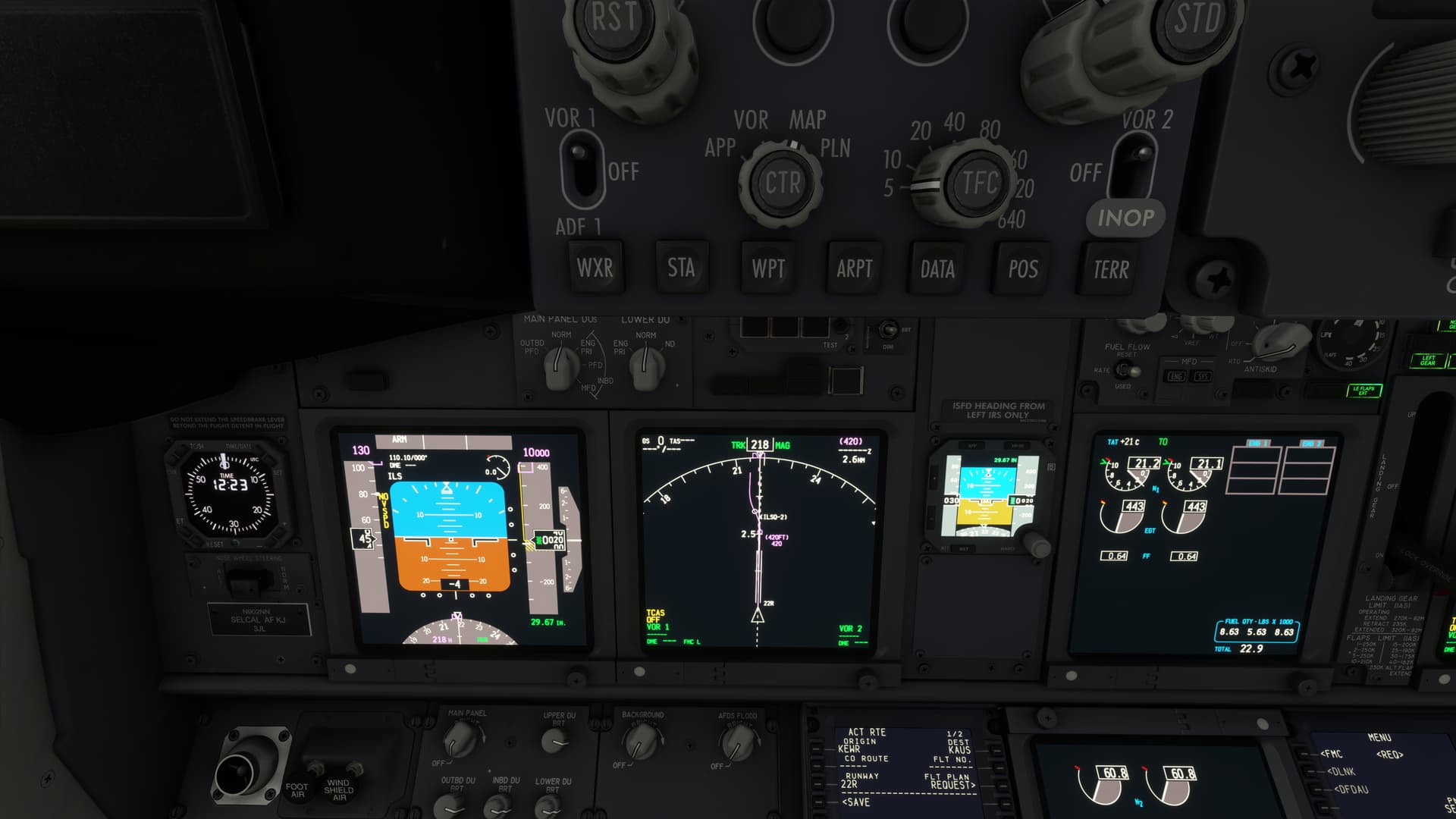
Departing on my flight from Newark, I needed to put an ILS frequency into VOR L as part of the 22R SID procedure (making a required turn when I am at a certain DME from the ILS). VOR R continues to automatically tune to the closest VOR.
Suppose I wanted to tune two VOR frequencies manually. How can I get one VOR or the other on the NAV page to go back to automatic/GPS tracking?
You don’t manually tune beacons for departures or arrivals in a 787. Simply input the SID or STAR into the FMC and the aircraft takes care of the rest.
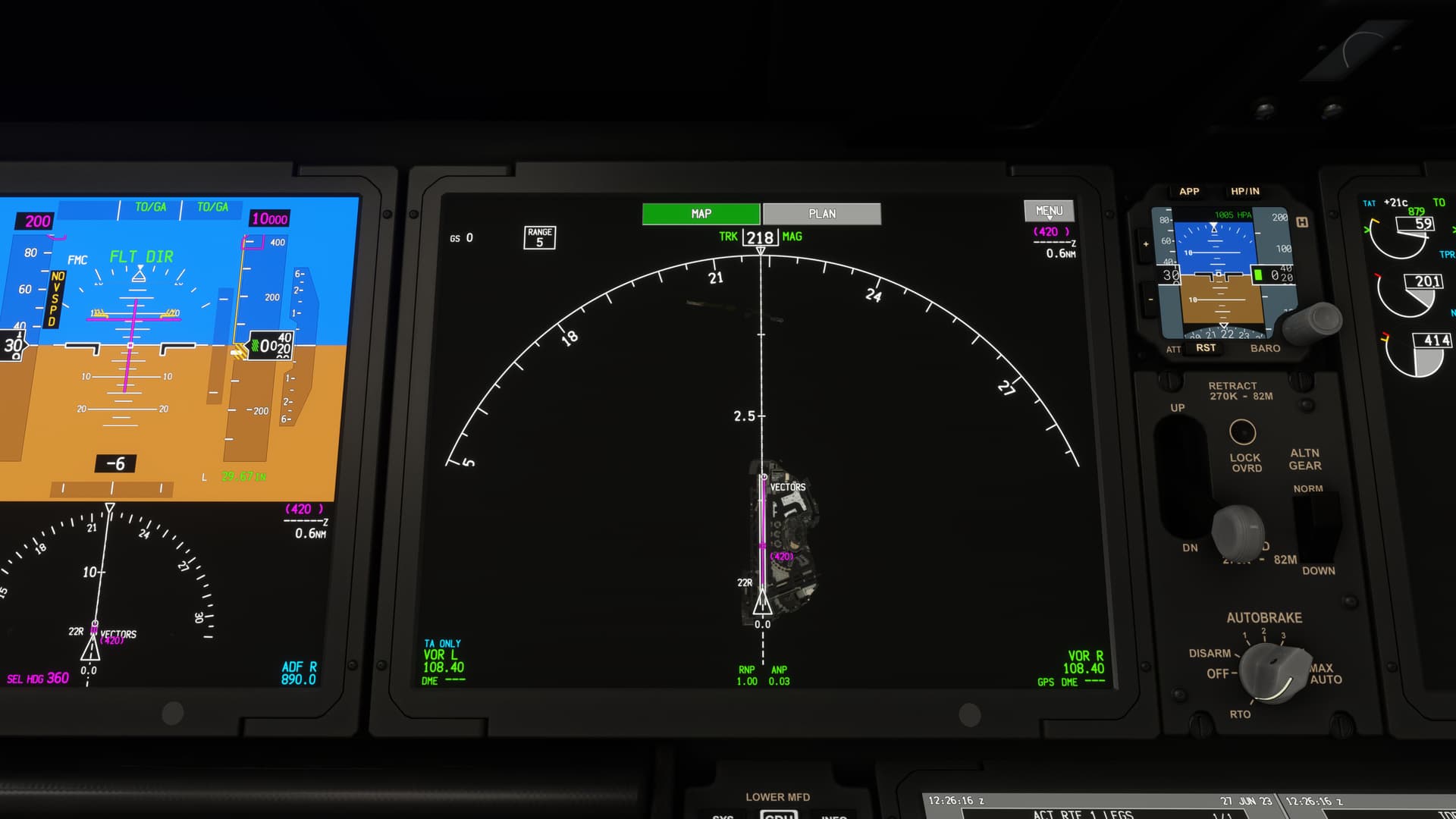
Not in this instance. The departure I used, the Newark 4 off of 22R, is more or less a vector departure. You’re required to fly a heading of 190 upon takeoff, and then fly heading 220 upon reaching a certain DME from an ILS frequency based at the airport. ATC then vectors you to a fix. Loading Newark 4 does not load the DME information for that second turn in one of the VORs.
If that’s the case then there’s something wrong with either the navdata or the aircraft in the sim, particularly if it’s a named SID. Routinely we simply don’t manually tune navaids in the 787 as there is no need, it’s designed that way. Are you using Navigraph? If so and we can determine it’s not the aircraft it probably needs reporting to them.
In the real world, in the extremely rare situation where you have no choice but to fly a departure like this we would generally use the fix page with a range ring but I’m struggling to think of an example where I’ve ever needed to do that.
The issue is the way the SID is depicted on the ND of the 787 I’m afraid. I’ve just compared it to the PMDG 737 using Navigraph data and the 737 draws the EWR4 as I would expect it to do.
Topic moved from the Aircraft sub category.
Aircraft is a sub-category for simmers to discuss existing and upcoming aircraft and liveries and constructively express their opinions and recommendations on specific aircraft and liveries.
If you have a specific question on how to fly or use an aircraft’s systems, please find an existing discussion thread for that aircraft in this subcategory ( Aviate, Navigate, Communicate ) and ask here, or if you would prefer one-on-one help, create a new thread here.
Please feel free to use the bug report template and enter a bug report in the Aircraft & Systems Bug Report sub-category.
As posted, this is a solved request on how to tune the radios in the 787.
A 737 is not a 787. 2) PMDG is not MSFS. 3) The MSFS 787 uses MSFS PLN files. The PMDG 737 cannot import MSFS PLN files but instead uses RTE files that MSFS cannot import. These two aircraft cannot be compared to each other including flight planning.
The MSFS 787 does import and flies the KEWR 22R EWR4 SID correctly. However, it creates a waypoint equivalent to the DME distance from the ILS without having to input the VOR frequency. It then correctly puts VECTORS next just as described in the SID. The 787 correctly displays and flies the SID. There is no problem with the 787.
Don’t expect that the 787 is going to work and look like like the 737 because they are different aircraft from different vendors.
Ain’t that the truth. The 787 is much bigger and faster
I don’t recall suggesting it was
This has nothing to do with flight planning or what kind of plan files an aircraft can read. When you load the respective aircraft on to 22R at EWR and load only the SID into the FMC one of these two aircraft draws the EWR4 on its nav display correctly, the other doesn’t.
As I’ve already mentioned, manual tuning of navaids is not required on the 787 by design which was my response to the original point of the thread. However, in the spirit of helping out I figured I’d elaborate a bit, and I can assure you that the real 787 displays the EWR4 in exactly the same way the PMDG 737 does in the sim (as demonstrated in the image I posted), which is of course the same way the real 737 does. You can clearly see a difference in the way the SID is displayed when using the same navdata. On the 787 it is not depicted correctly despite the waypoints being correct in the FMC.
I don’t expect the PMDG 737 and the WT/Asobo 787 to be like each other, but I’d rather hoped they would be like their respective real aircraft. One is, one isn’t (but is much better than it was), and I suspect the one that isn’t is that way because of a bug.
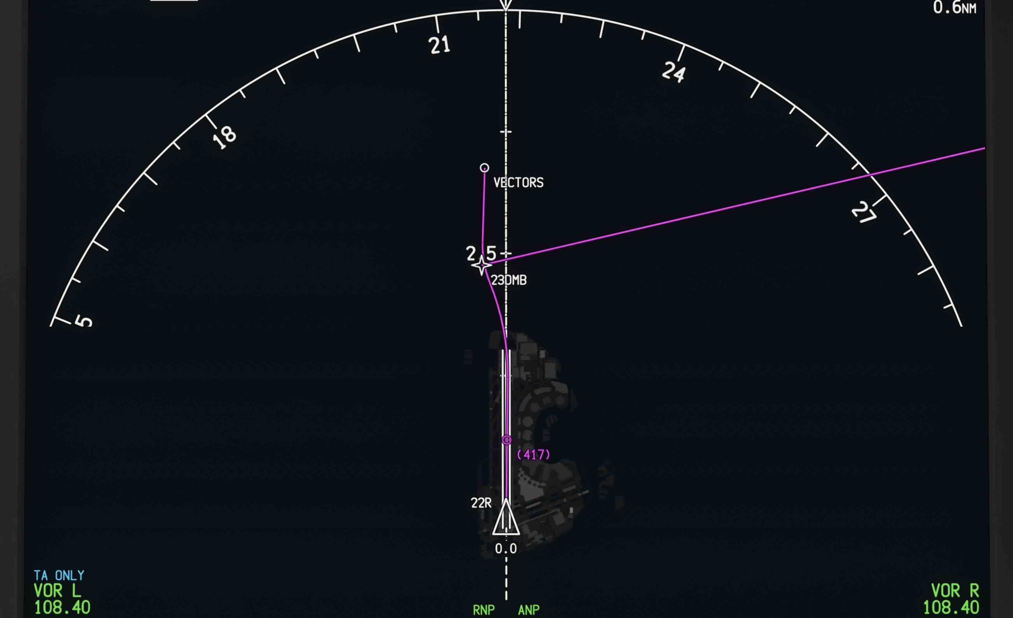
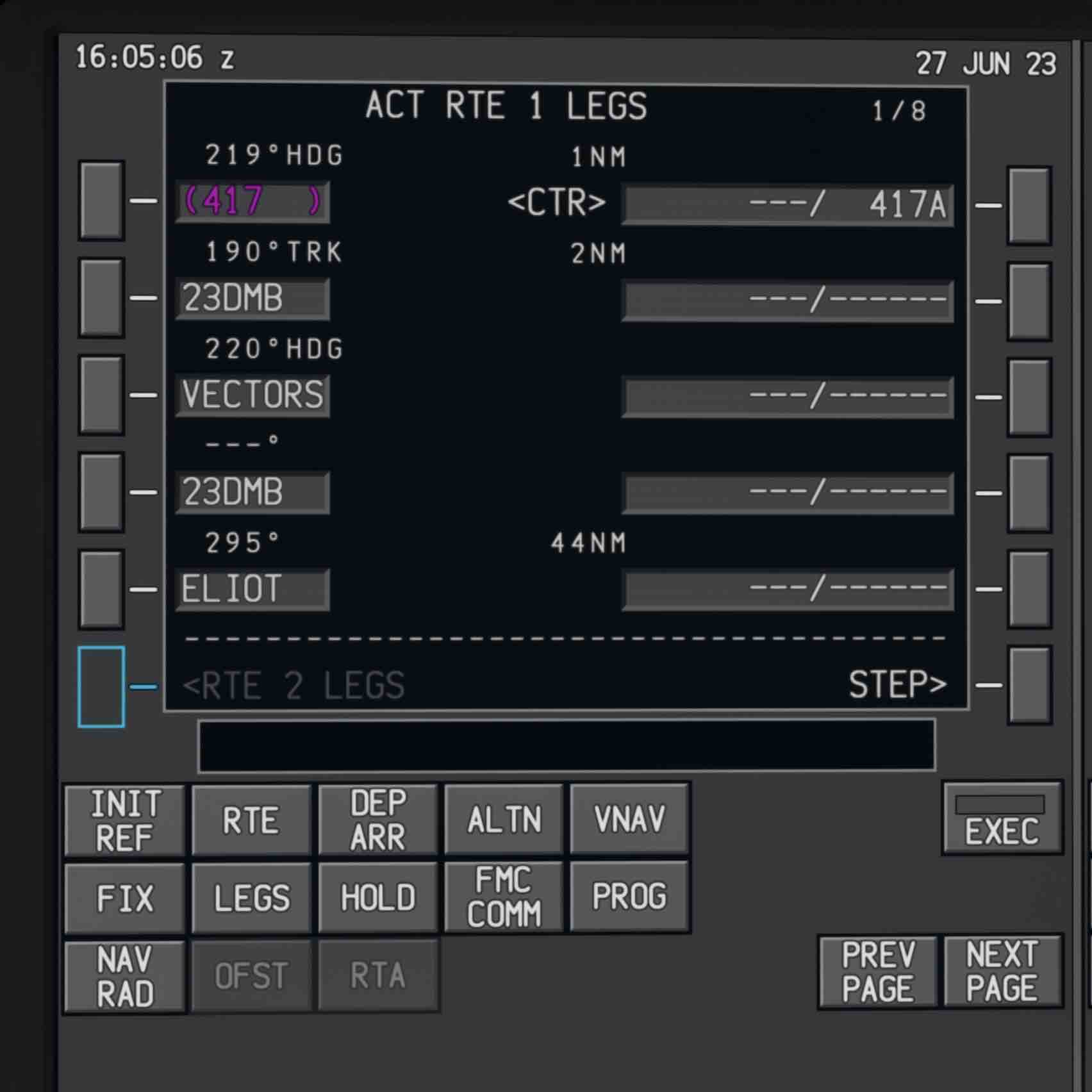
I created a flight plan departing KEWR 22R EW4 importing it into the 787. Here is how the flight plan is displayed on my 787. It is different than your 787 display.
We might not be using the same navigation data. My display looks similar to the 737 display except the 737 display is oriented North. The 787 display is oriented to the aircraft heading. I’m still not seeing any problem with the 787.
If you simply load the 787 on to the end of 22R at KEWR and load the EWR4 into the FMC it doesn’t display correctly. I don’t believe that’s intentional behaviour, it’s a pretty basic thing after all.
I’m not sure what you mean about the displays, they’re both orientated to the aircraft/runway track.
Load the aircraft on the 22R at Newark with no flight plan. Once you’re there enter the EWR4 22R into the FMC and look at what is depicted on the ND. What you will see is what I showed in the image I posted, which is wrong. What you should see is exactly what is depicted in your image, and my image from the 737. The FMC legs page in the 787 is correct, the ND isn’t. It is correct in your image (initially at least), but you have arrived at that point using the flight planning system rather than the aircraft itself.
Where I said initially, I’m pretty certain that what the legs page in your image displays is incorrect, but I don’t know how you’ve arrived at that. In reality on the 787 it simply draws a continuous line on the vector track on SIDs that use them. I don’t think it’s infinite but can’t remember off the top of my head how far it is drawn. The next waypoint should be the point after the vector, so in your case ELIOT. You would not have the waypoint before the vector as the first waypoint after the vector if that makes sense. That could land a distracted crew in a whole heap of bother.
We’ve looked into this case specifically and as best we can tell this is a Navigraph navdata issue. The reference ICAO in the data for the ILS DME facility is not valid and does not exist in the sim with Navigraph data installed, therefore the aircraft cannot compute the DME leg end. With a valid reference facility the aircraft computes the correct path.
This issue does not exist in the 737 version of the navdata, for whatever reason.