A VOR was off by 5 degrees. List of problematic VORs?

I’ve been flying around Northern California, Italy and New York and the VORs seem to be operating correctly.

However, flying around Arizona and Utah some of the VORs are off.

I just used EHK 117.3. LittleNavMap said the vector I wanted was 359. Comparing my flightpath in realtime against the VOR line drawn, I was off. I kept adjusting the OBS, and figured out that using 4 degrees was the correct vector I should be using. So it was off by -5 degrees.

However, I was also using PUC 115.50 as my distance VOR, and the heading off that ended up aligning right over the airport, so that one was correct.

I’ve also noticed a few others in the southwest area of the US being off for the past month. I’ll update this post with the name of them as I encounter more.

Anyone else seeing this? If so, is there a known list of problematic VORs out there somewhere?

When you say

what exactly are you referring to? Maybe you have a screenshot?

Which aircraft? I seem to remember that there was an issue with the steam C172’s OBS being off by 4° - not sure if it was ever fixed. Also, remember that there’s a difference between true and magnetic heading. I’m not sure which one VOR’s are supposed to use.

Probably a daft question but, when you say it’s off, are you comparing your track with the VOR radial, or your heading required to stay on that radial?

Is it simply a case of a crosswind component requiring a different heading to maintain tracking the radial?

I ask because you say when you reach the VOR, that your distant VOR shows the correct radial.

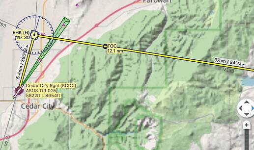
Here is a screenshot:

Imgur

Flying the stock Cessna 152 I have my NAV1 radio set to EHK’s frequency of 117.30. My OBS is dialed to 54 degrees, using the magnetic bearing of the VOR (which is the correct one to use for the C152 nav radio)

In the sim, my OBS is lined up with 54 degrees and I’m flying straight along that vector. As you see from my plane’s position in yellow, it is off by 5 degrees.

The other VORs around this particular area are correct, its just EHK that is off. I have, however, also run into this issue with a few other VORs. Since posting I haven’t found another one, but I’ll update if I do.

Am I just missing something obvious, or is this a bug?

Thanks for the screenshot, here are my thoughts - it looks like at least in part it is related to magnetic declination. If you dialed in 54 on your OBS it shows the 54 degree VOR radial, which is not the same as the magnetic course you have to fly to follow it (unless the magnetic delclination is zero or the VOR has been recalibrated to magnetic north on a regular basis, which is usually not the case). Depending on the VOR it could be indeed 5 degrees off, even more.

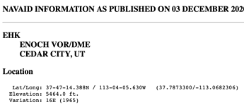
Here’s my explanation for the 5 degrees you see for EHK (I’m new to all this too so I might be completely wrong): the published magnetic variation (which seems to be from 1965) for EHK is 16 degrees East (you can see it in the VOR info in LNM). The current declination today for the EHK location is only around 11 degrees East (I put in the coordinates at https://www.ngdc.noaa.gov/geomag/calculators/magcalc.shtml#declination), which would result in having a magnetic course difference of 5 degrees to follow a radial.

Dirk

I just tested another random VOR, and it is totally fine. Here is a similar set up with a VOR near Tahoe:

Imgur

In this example in a C152 I have my Nav1 radio tuned to 113.20. My OBS is dialed to 19 degrees.

In the sim my OBS is lined up at 19 degrees and I’m flying straight along that vector. As you can see from my plane position in yellow, I am right on that correct vector.

If the explanation of magnetic deviance was true, this example should be off as well, shouldn’t it?

Yeah, published VOR variation is 16E, and current declination is around 13E, so there should still be a 3 degree difference using my explanation.

Dunno, I guess I was wrong, or maybe MSFS is not correctly modeling it

Dirk

It is a very strange bug. I can’t really wrap my head around where the breakdown is happening.

Could it be that LNM is reporting the wrong vectors for the VOR? Could it be that the Nav Radio/OBS is bugged in the C152?

It’s weird because as I showed other VORs work fine… which makes me think it isn’t an issue with the C152 in game.

I checked the same vector for the EHK VOR in SkyVector, and it gave me 54 degrees as well. So that leads me back to thinking it is a bug in Flight Sim.

Ok, I did some testing, and I don’t think there’s anything wrong with MSFS here…

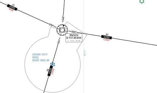
If you look at the airways that are going through EHK:

you should follow V235 when following radial 001 (dialed into your OBS), and follow V293 when following radial 083. I just tested this in the TBM, and indeed I was dead on aligned with these airways (on both Navigraph Charts and the LNM map). But the actual magnetic heading I was flying was 006 and 087 respectively, which more or less agrees with my previous explanation of being around 5 degrees off because of the difference in historic and current magnetic declination.

When I put this FlightPlan into Pilot2ATC it lists 005 and 088 magnetic headings to fly, which is pretty close to what I saw in the Sim. But - LNM shows 360 and 084 degrees magnetic, which is indeed wrong:

So I’d argue this is a bug in LNM.

Dirk

I was leaning towards that as well, but SkyVector reports the same wrong heading on that VOR…

Are they both using outdated info for that VOR?

Is this a common issue with flight charts? Is there any way to tell if a VOR is outdated from the chart itself?

Yeah not sure what SkyVector is doing here… For my example above it shows 005 magnetic heading to stay on V235 (which agrees with my explanation), but for V293 it shows 083 (same as LNM)

I’d think they all use the same published (and outdated) magenetic variation of the VOR, the question is how it is corrected for today’s declination, and what MSFS itself uses for magnetic courses inside the sim

If you are using airways on flight charts there should not be an issue at all, as they are defined as radials between VORs and do not depend on magnetic headings. So as long as you dial in the radials in the OBS and keep the needle centered you should be staying right on the airway

My guess is that almost all VOR variation data is somewhat outdated, just to a more or less degree… Neither LNM nor Navigraph show the year the VOR variation has been set, but you can google the VOR and often it’s displayed

I wished some real-world pilot would chime in here to take out the guess-work and shed some light on this.

Dirk

Yeah the issue I have is I’m using VORs to pinpoint the location of hard to find grass strips I’m flying into with NeoFly… so I’m not just using them for airways.

So having a VOR be off by 5 degrees when I’m in the middle of the desert with not a lot of good landmarks to orient myself is a pretty bad situation to be in.

As far as I remember my flight school lessons, VOR radials give magnetic bearings. Since true north is not a factor, magnetic variation doesn’t matter.
If the needle shows him dead center radial 054° but instead on the map he is way north of that radial, then it’s a bug with that VOR in MSFS or the map is wrong.

OK, so seeing how both Little NavMap and SkyVector are both giving the same radials, and when using them in MSFS I am off by 5 degrees, it is most likely a bug in MSFS then?

Actually, I believe true north is very much a factor, and magnetic variation does matter. Only if the VOR is correctly calibrated to the magnetic declination at its location, at the current time, the magnetic heading and the VOR radial will be the same.

I just found this link that explains it well: https://www.aero.sors.fr/documentation/UnderstandingMV.pdf

As I laid out before, I don’t think it is a bug in MSFS.

Dirk

Some of the terminology being used may not be making things clear.

VORs have 360 RADIALS, they are magnetic and current charts have the VORs aligned with magnetic north. To fly a radial accurately you will TRACK along the radial by adjusting your aircraft HEADING to account for cross track drift caused by the actual wind vector. If you manage to track along the radial successfully for a few miles, your TRACK MADE GOOD will be equal to the radial direction, though you may have had to constantly correct your heading to maintain that track. The easiest way to oserve this is to engage the Nav mode of the AP to track a specific radial and then alter your airspeed or altitude and watch the AP heading change to take account of the change in wind vector and drift.

The aircraft will have an up to date airac database loaded, or if just using charts and inputting frequencies this must also be in date for current use. It’s the aircraft commanders duty to ensure these are up to date before using them.

Of course in the flight sim world many things can be in error. Sim pilots themselves very often have no real world training, no current charts, and the software itself may be out of date or contain errors.

One other small detail when using VORS is that your distance will be expressed as slant range from or to the VOR, not chart range, unlike GPS range from a way point. For instance, ir you’re at flight level 300 in an airliner, with the VOR at sea level, the closest the DME will show is 5 miles as you pass overhead, as you are 5 miles above the VOR. At 6000 feet the DME would show 1 mile.

So if you’re overhead a VOR/DMEat fl300 (30,000’) it will indicate 5 miles, whilst a second VOR/DME say 45 miles away will show a DME of around 46 miles, because they’re both showing slant range.

If the VOR was physically built way in the past, then its radials may not be lined up with the current magnetic declination of the area. The VORs are not constantly updating themselves.

The official FAA IFR enroute charts will have taken this into account when they tell you which radial to use for an airway.

It seems like LNM and SkyVector may not be taking this into account? I think more testing is needed.

Here is a PDF from Civil Air Patrol illustrating how magnetic variation over time causes VOR radials not to line up with current magnetic courses - https://savannah.cap.gov/media/cms/VORRadialsvsMagVariation_0CFCC08B02E70.pdf

Also, this document from Australia talks about error in the VOR system which can be up to +/-5 deg and why they are not considered a precision system to begin with - https://www.casa.gov.au/sites/default/files/vhf-omni-range.pdf

Edit: Updated this post after I originally wrote it, to avoid leaving incorrect information in it.

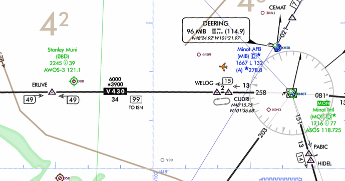
Let’s use KMOT and the MOT VOR as an example, since that is in the helpful Civil Air Patrol document I listed above.

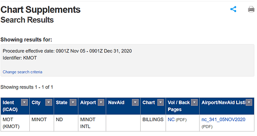
KMOT search in the FAA’s Chart Supplement Database

In the ‘Airport/NavAid List’, the MOT VOR is listed as having its 360 degree radial oriented at 13 degrees east of true north:

This data is current through 31 Dec 2020 per the footer at the bottom of the PDF.

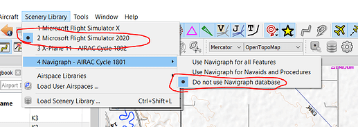
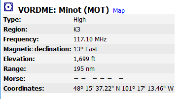
This is also what is shown in LittleNavMap if you look at the ‘information’ for the VOR, with the MSFS scenery database providing all Nav data (this setting is very important, or else you’ll end up using an out of date Navigraph database for Navaids, which includes VORs)


image

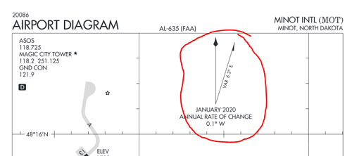
The current magnetic declination at KMOT per the Airport Diagram (page 144 of the PDF) is 6.3 degrees east of true north:


This data is current through 31 Dec 2020 per the footer at the bottom of the PDF.

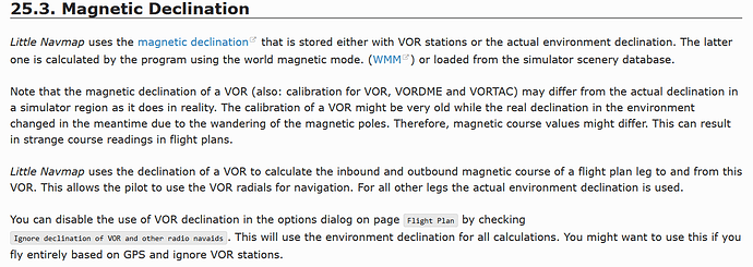
LittleNavMap says the magnetic declination of the airport is 7.1 degrees, ~1 degree off. Per the LNM manual it uses the World Magnetic Model for everything that isn’t a VOR, so the numbers may vary a little from what is on the Airport Diagrams:

image

So per the FAA data there is a 13 - 6.3 = 6.7 degree to the west delta between the orientation of the VOR 360 degree radial, and the current magnetic north at KMOT. (Assuming another year of change, it could be up to 6.8 degrees). Flying the 0/360 deg radial of the VOR, should put our heading at ~7 degrees magnetic.

Per LNM data the difference is 13-7.1 = 6.9 deg

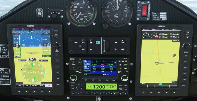
Let’s check this out in the simulator by flying along a radial and see what we get. With the SW121, flying along the 258 radial of MOT VOR should intersect with ERUVE:

The error is about 0.6 nm at a distance of 49.9 nm from the VOR, which is about 0.67degrees, and we can only adjust CRS in 1 degree increments. So it seems like the simulator is taking into account at least the orientation of this VOR correctly. If it wasn’t, the error would be on the order of 7 degrees, about 10x as much as what is measured:

I’ve seen the same performance in the SR22 (G1000), currently working on testing other aircraft.

Are you using the Navigraph beta nav data for MSFS? Which aircraft were you flying, and were you using any aircraft mods?

1 Like

Thank you very much for the detailed insights, it’s pretty much in line with my own understanding and it’s great to get this confirmed from someone who seems to know the subject well.

Yeah I have a Navigraph subscription and use the beta nav data for MSFS, and have my other tools (LNM, P2ATC) updated to the latest Airac cycle as well, so everything should be in sync. I’m primarily flying the TBM930, and use the tbm930-improvement mod and the g3000 mod.

I didn’t mean to say that there’s nothing wrong with MSFS at all, I was only looking at that specific case of the EHK VOR that the OP mentioned. Based on my understanding the magnetic heading required to stay on the airways (or radials) going through this VOR should be around 5 degrees different (based on published 16E variation from 1965, and current location declination of 11E), and that’s exactly what the OP reported. And when I flew these two airways through the VOR in the TBM using this 5 degree off heading (006 on V235 and 087 on V293) then I did indeed follow the airways dead center, and P2ATC listed the same magnetic headings in its flight plan. But LNM showed 000 and 084 as the magnetic heading to fly, hence my suspicion that it’s a bug in LNM.

Of course there may be related bugs in MSFS too (you actually showed that it’s even dependent on the aircraft), but for this particular VOR it seemed to me that it was behaving as I would have expected.

Thanks!

Dirk