Content deleted, this addon is no longuer available.
Very good. I recomend. Six different tipes of maps among other features.
This looks promising.
Jim-Sim
Neat .. well done .. But
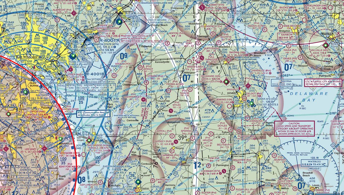
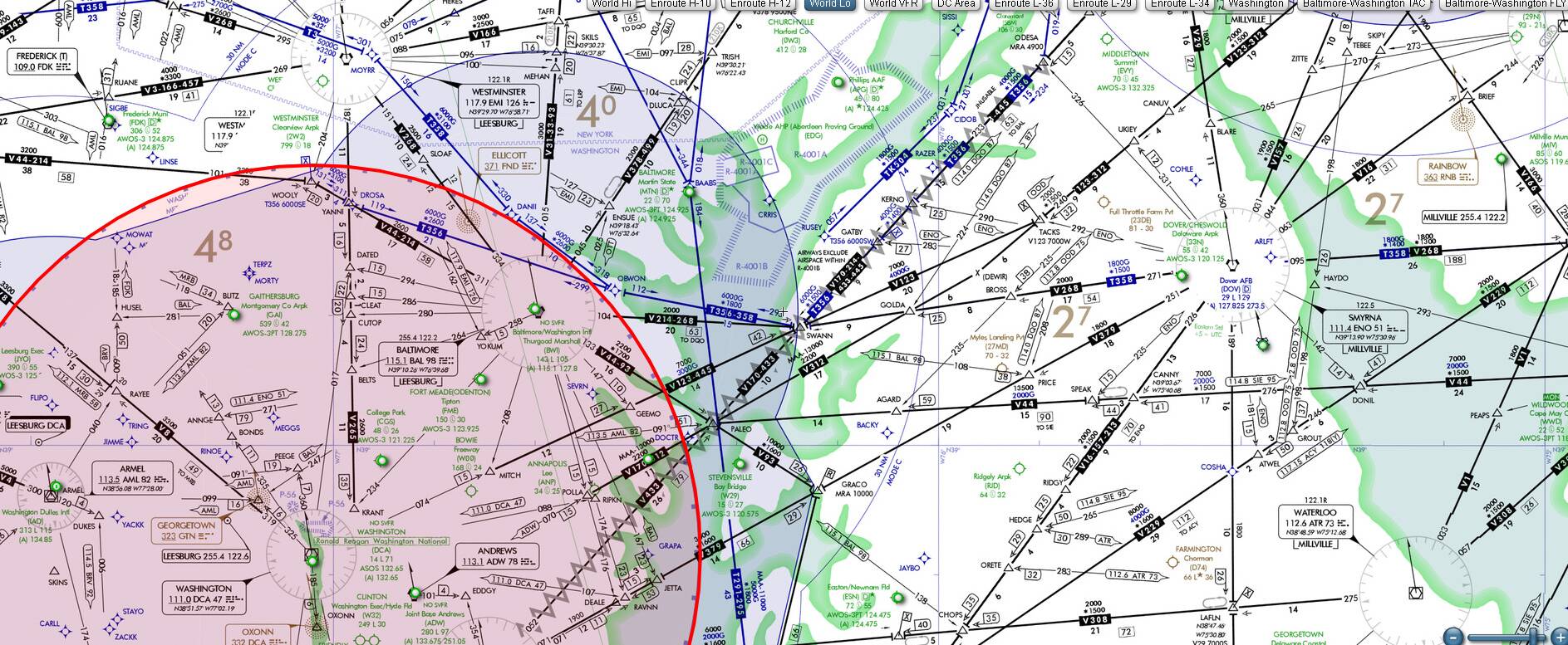
Even as a VFR map, you really need it to display Air Spaces etc, like a VFR CHART ?
I find a better solution is LNM (Little Nav Map) which does this .. and a LOT more if wanted.
wow, looks really good! going to try today
I’m not that particular when it comes to airspaces when I fly VFR. For me this is ideal. Little Nav Map is a little too much for me. This is much more user-friendly.
But adding Navaids and airspaces is definitely an idea for further improvement.
Multiplayer display is a plus for me witch LNM can’t do right now
This looks good. But I need to pass this on. It may not mean anything but it did concern me.
I watched the video and then clicked on download. My McAfee firewall stopped the download and reported “This file might have viruses, spyware or other potentially unwanted programs in the file”.
Being the chicken that I am, I stopped the download.
Again, it may be perfectly fine. I’m sure there is a reasonable explanation for the McAfee report out.
JFYI: If we put aside the VFR Map plugin in this topic, McAfee has a high ratio of false positive alarms.
This is the reason, I had to get rid of AVG and Avast. They sucked a lot of my blood with those alerts.
On this website you can find comparison tests (and on this page specifically False Positive Rate
False Alarm Test September 2020 - AV-Comparatives (av-comparatives.org)
On the same website on other pages there are comparison charts on other parameters.
Again, I am not talking about this plugin, rather on the McAfee.
Is it possible to add a on/off switch so user be able to turn it off when little privacy is needed?
I was previously using VFRMap but it hasn’t seen any updates for around 4 months now.
I too, believe LittleNavMap is more program than I need.
I began using SimToolkitPro and find it to be great, but I’m really only using the Nav Map portion of it for now.
This tool seems to fit right in the middle. I’m at work right now and have not yet installed this, but according to the video, it appears to work directly inside of MSFS2020 (effectively replacing that pitiful map version included).
For those concerned about it having a virus, I’ll chime in with @SkyHead81 and say that even VFRMap gave these false positives to the virus software. The creator even explains why this happens on his github site - apparently this is common amongst smaller code writers.
I’m looking forward to getting home and installing this.
Jim-Sim
Thanks for that Tip ![]()
I would also agree, simple is good – so if the Developer can add Airspaces as an Option ( and other Nav features) – Ideally a VFR Chart Background, then that would be ideal (at least for me). LNM is Amazing, but it can be an over-complicated OVERKILL at times.
Do any MAP addons for MSFS have “realistic” VFR or IFR Charts as their maps ??
LOL please don’t fly in real life ![]()
Just installed it and will give it a try for a few days - I like that I can display it on a separate device (I’ve got a mostly redundant original MS Surface which displays it okay). Up to now I’ve used Little Navmap, which I find really good, especially with it’s own Google Maps background, together with VFRMap and flip between the two on a second monitor.
Seems you can only add a flightplan in the browser you’re using, it doesn’t carry over to other browser views? And I don’t see that flightplan in the sim window either? Tracking and Telemetry seem to work fine. Nevertheless I’ll give it a try.
As for the download security BitDefender accepted it okay but Windows Edge put up a warning. But remember ANYONE can view it, there doesn’t seem to be any privacy settings!
Wow !! thank you for your interest for our project ![]()
I will try to reply to all your questions/suggestions in this post (be indulgent, english is not my native language).
Our aim is not to do another little nav map (we do not have such ambition), but to do a simple and easy to use tool for peoples, like us, who just want to take pleasure (we are French after all ![]() ) flying around the world to discover beautifull places.
) flying around the world to discover beautifull places.
That said, keep in mind that our addon just come to life, we will add features, and one the purpose of this conversation is to know what could be added and in which order.
So from what we read from your replies, we have decided that the next step will be to add airports and navaids to the maps.
Concerning VFR charts and airspaces, the real difficulty is to have open data.
Our addon if free and to my knowledge there is no free data for that. If you have some links where we could find those data, we will be happy to add those features.
About the fact to not be displayed on the public map, we will add the possibility to create private map soon.
About flight plan created or imported in browser which are not displayed in game: it can’t be possible until we create “user space” (login in browser and in game to share data).
Concerning virus detection, we will not ask you to trust us, so here is the result of Virus Total analyse :
Thank you again for your interest, it’s a great pleasure for us to see all these planes on the map ![]()
That is the problem, together with getting the plane to display in the correct position on Charts.
Even assuming if the user could download charts (ie from Skyvector) and use those, getting the map software to be able to sync position to those static Chart Images is a “Challenge” ? or maybe not ??
For sectional type map overlays, I’ve seen most people using this.
Not perfect, but works great.
I’m not sure what the question/problem is. However, my free flight planner uses Bing Maps and OurAirports which are both (in essence) free.