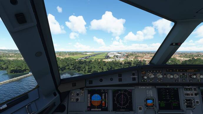
Hi,
I just bought Bali Airport for MSFS from SimMarket yesterday on Aug 15th.
I downloaded the latest version 1.1.0.0
After I installed it, I tried to perform ILS RW27 Approach. But the ILS guides me to land on top of the terminal building.
I already tuned the right ILS freq, which is 110.3 and course of 267.
Then, to test it, I also tried to use default MSFS Bali airport (uninstall Aerosoft WADD airport), and the ILS RW27 on default MSFS airport works fine.
I’m wondering if you guys who have this addon got similar issue.
Thanks.
When I reviewed it a while ago, the ILS was correct, but this doesn’t mean much because updates may have screwed it up. I’ll try to test it later.
You’re not using Navigraph’s data right?
Yeah. The ILS definitely got screwed up since the last time I flew there, and now it does its best Harrison Ford impression. 
All you can do is report it on Aerosoft’s forums and hope they fix it soon. But yeah, the issue is not on your side.
1 Like
I installed NavData from Navigraph.
But, does that matter? because when I removed Aerosoft WADD and just plain default airport, the ILS27 works fine.
Thanks for confirming. I’ve posted this issue on Aerosoft support forum, but haven’t had any response. Perhaps I’ll just wait a bit. Meanwhile I’ll temporary remove this addon.
Interesting, so it gives you the same result with Navigraph’s data?
PS: can you link your thread on the Aerosoft’s forum? I’ll post my findings there as well.
Yeah. I think NavData only affects the waypoints, SID, STAR, Appr for flight planning.
The Navaid like ILS or VOR is usually coded into the Airport AFCAD bgl files.
Btw. here is the link Bali Airport ILS Runway 27 Mis-aligned - Airports - AEROSOFT COMMUNITY SERVICES
Navigraph’s Navdata actually fixes a lot of ILS issues, that’s what I asked. Strange that it’s the same as Aerosoft’s.
Just to clarify, all scenery dev includes the ILSs in their scenery and thats absolutely necessary because the devs can’t expect that everyone has a Navigraph subscription.
Our package will be installed at a very low scenery position. With that “solution” the scenery dev can be sure that his ILSs, terminal procedures, … will be used because the scenery has a higher prio and overrule the navdata update.
We are currently testing some new ordering for the future updates. But till the release, when you have a Navigraph subscription, you can try the set the navigraph-navdata package/line in the content.xml file on the last position (bottom).
After that restart the sim and try it again. The effect is, that all ILSs will be really used from the AIRAC cycles and are always uptodate and 100% correct.
Cheers
Richard
3 Likes
@NAVData Thanks for the explanation.
I actually have a curiosity if you don’t mind indulging me. Does Navigraph’s Navdata influence the glidepath angle of RNAV approaches at all?
I’m guessing it doesn’t, because with the method you mentioned I couldn’t fix a glidepath issue with a new GMMX scenery (way too low), but thought I’d ask and make sure.

