Altimeters: Radio versus Barometric

Hello.

Assuming that an altimeter has been correctly calibrated with a nearby QNH - how accurate would you expect it to be it in the real world of flying? If your aeroplane also has a Radio Altimeter showing a different altitude which instrument would you rely on? Or perhaps a significant discrepancy does not occur?

I look forward to your thoughts.

Mike

Barometric altimeters measure height above mean sea level. When the local QNH is set it should read within 75 feet of the airports published altitude when on the ground. This should be done as part of your preflight inspections.

Radar altimeters measure height above the ground. The two reading will rarely be the same and you can’t use one to check on the accuracy of the other.

1 Like

You’d use a combination of both
Barometric is above sea level
Radio alt is above the surface be it ground or water.
They both would potentially read different altitudes depending on where you are.

You wouldn’t expect them to show the same reading at any given time as they are measuring different things.
The barometric instrument is measuring height above sea level and changes as the aircraft climbs or descends.
The radio (radar) version is measuring the height above terrain beneath the plane and will fluctuate with hills, buildings etc. even if the plane’s altitude remains constant.
If there was a difference between what the published values on each should be during an ILS approach in instrument meteorological conditions (IMC), you’d want to go missed and sort things out since both instruments can be wrong; blocked static ports or electronic problems could affect each respectively.

1 Like

Thank you everyone. I have learnt a lot from your replies.

Hopefully I can continue to develop as a more accomplished ‘simmer’.

Mike

2 Likes

Another point of interest: Pressure altimeters are calibrated for the standard atmosphere. You have to do a bit of math to correct the reading you see on there for the actual atmospheric conditions. Analog computers like the E6B make this quite simple.

You can download an E6B app for your phone and try it out. If you want to check your work, compare the altitude you’ve computed to the altitude shown in something like Little Nav Map. They should be fairly close.

Edit: here’s a screenshot of the one I use:

My word! Is that degree of precision ever required?

Certain weather conditions can make the difference significant. And if you’re bumping along in the clouds, that can be the difference between clearing or hitting the embedded cumulogranite


1 Like

Mostly relevant when it’s much colder than standard temp, which can cause you to fly several hundred feet closer to the ground than indicated. This is the primary reason why some cold-weather airports have instrument approach minimums that are higher or require conversion when it’s very cold.

1 Like

In terms of the original question, it comes down to what kind of flying you’re doing. 95% of civil aviation is done in reference to barometric altitude above mean sea level (MSL). These are our cruise altitudes (from which a lot of navigation derives), our aircraft performance, airport elevations, terrain and obstruction elevations, minimum enroute, segment, (and other) altitudes for IFR flying, and lots more, including most weather phenomena (* see below).

Radar altimeters measure absolute altitude in feet/meters above ground level (AGL). In the civil world, AGL is referenced in regard to charted absolute obstruction heights, charted height above airport (HAA) for circling instrument approaches and height above touchdown (HAT) for straight-in approaches. It is also used to delineate the floor of various airspaces, VFR weather minima, and general minimum safe altitudes. *AGL is also used to report cloud/visibility heights on METAR and the various voice-output reporting systems.

In terms of using AGL in the civil world, your radar altimeter may cue decision heights on instrument approaches (especially on CAT II/III approaches), and feed information to the autoland system as well as the ground proximity warning system (GPWS). It’s also often used for aerobatic flying (edit: AGL is).

The radar altimeter itself causes you to have to pay attention to the ubiquitous 5G NOTAMs. :rofl:

In the military, the RA is often used to conduct terrain-following or nap-of-earth flying.

2 Likes

I am very grateful for your (and everyone’s) help and wisdom. I find this fascinating.

If I may go back to basics: When I look at a Jepperson ILS Approach chart. I understand that I should intercept the Glide Slope from ‘below’ and a level approach altitude is prescribed for me to fly in order to achieve this.

Am I correct in thinking this prescribed altitude is AGL and that I should add the runway height to my Altimeter reading to give me the correct approach altitude as shown on the altimeter?

(The airports that I have so far visited are in the U.K. are not significantly above MSL).

1 Like

No, almost all altitudes you see on an approach chart are in MSL. But as you noted, most airports in the UK are so close to sea level that it masks the difference. I picked one of the higher ones, Leeds Bradford, (airport elevation 681’) to demonstrate:

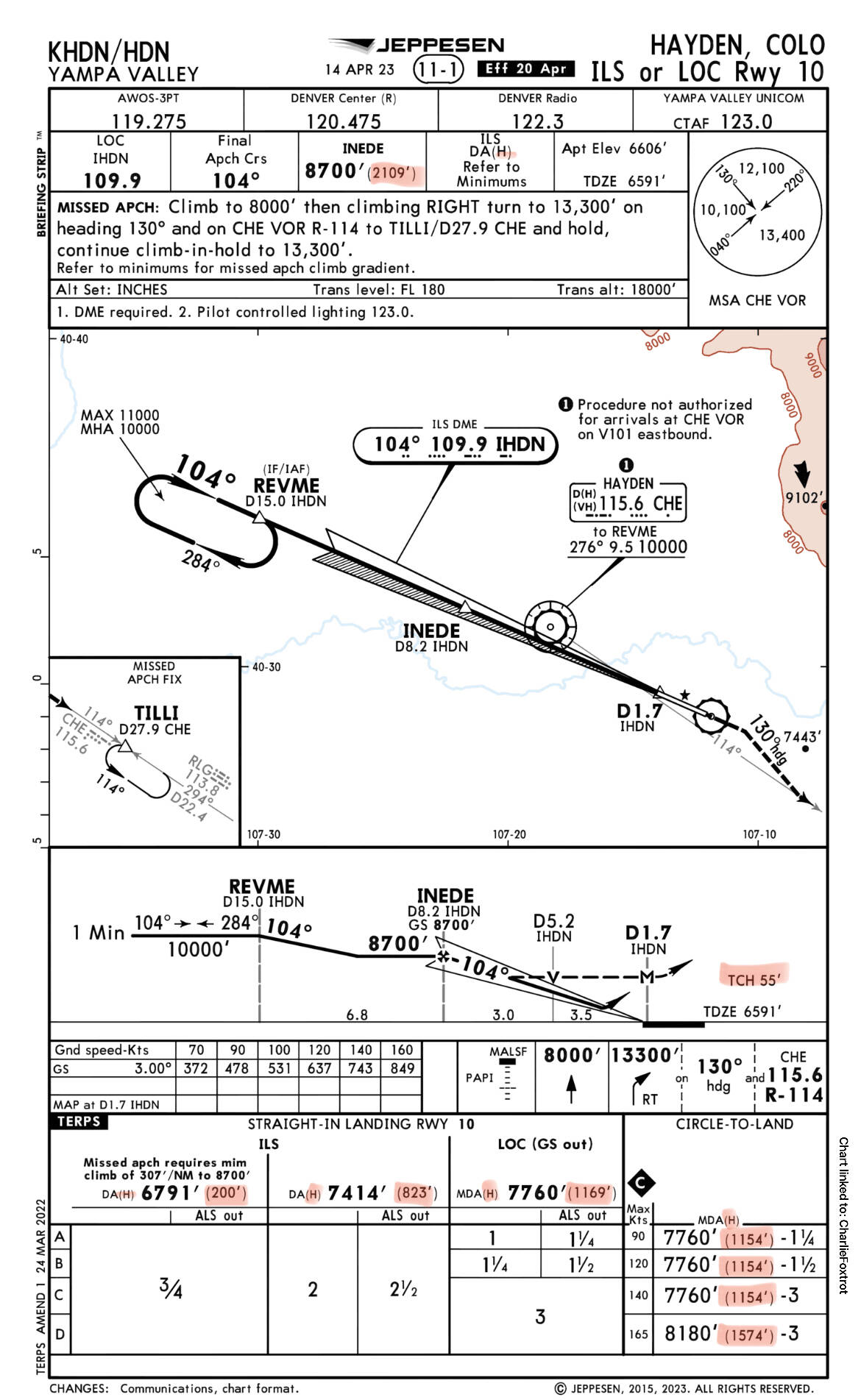
All the altitudes you see on the approach chart are in feet MSL, with the exceptions of the ones I highlighted in red:

In the bottom “minimums” section of the chart, you see DA(H), which refers to the Decision Altitude, used for the full ILS option of this approach, given in feet MSL, 874’ in this case. However the (H) part next to that refers to Decision Height, which is the value inside the parentheses (highlighted in the pic). This is the height above touchdown, given in feet AGL, 200’ in this case. Note that this is also repeated in the briefing strip along the top of the chart.

Where you see MDA(H) refers to the Minimum Descent Altitude, which is used for a non-precision approach (the Localizer only option of this approach), also given in feet MSL, 1190’ in this case. But similar to the ILS, there is an (H) in parentheses here, referring to the Minimum Descent Height, which refers to the parenthetical value again. This is also the height above touchdown, given in feel AGL, 516’ in this case.

You also have circling minimums, which are another MDA, expressed in altitude above airport (MSL), and height above airport (AGL) inside the parentheses (highlighted again), 739’ and 929’ AGL for category C and D aircraft, respectively.

Because the MDAs may put you in various positions from which you will commence a final descent to land, the AGL heights given in those cases are mostly a reference for how high you are above the airport or runway for both clearance and to calculate the descent rate or descent point needed to make a normal descent to land from the MDA.

One last AGL altitude on the chart is the TCH, which is the Threshold Crossing Height - so you know how high you should be above the runway when you cross the threshold on the glidepath.

No. Altitudes shown on an approach chart for glideslope intercept are referenced to the barometric altimeter. The “minimums” part of an approach chart - which is the altitude at which you have to declare a missed approach if you do not have sight of the runway, could be referenced to the barometric altimeter or the radio altimeter. It depends on the approach category.

Radio altimeters only indicate up to a maximum height of 2,500 feet above the surface. The only time the barometric and radio altimeters would have the same indication would be if you were doing an approach to a coastal airport and were flying over the ocean.

For comparison, here’s the ILS Runway 10 approach chart into KHDN - Yampa Valley Airport in Hayden, Colorado, USA, at over 6600’ elevation. The AGL references are again highlighted in red, but notice how high all the other MSL altitudes are, despite fairly similar angles and distances at play (actually the ILS glideslope is 0.5° shallower at KHDN!).

And I forgot to affirm one of your notions above - yes, intercept the glideslope from below. :slightly_smiling_face:

Thank you and @HalberQuacky for your assistance. You have put a lot of trouble into your explanations and I am very grateful. The Hayden example was particularly useful.

I have a much better understanding of the charts and ‘minimums’ now and will doubtless enjoy my approaches far more given my better appreciation.

I did chuckle at the ‘THC’ parameter - how on earth does one have the chance to review and check that given the stress of landing and all the other things!? I am delighted to simply get across the threshold!

1 Like

No problem! All of this is part and parcel of the things we have to understand in order to obtain (and maintain) our instrument rating. It’s standard practice to brief every approach and eventually you learn which information is pertinent (based on several factors) and which can be safely
 I don’t want to say ignored, but mentally filed away or just reserved for later lookup.

1 Like