Group flights, Aussie style. Aussie Group Flights Team is the ultimate way to explore the world with your favourite people.
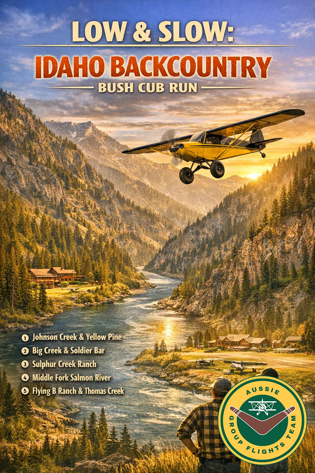
 LOW & SLOW — IDAHO BACKCOUNTRY BUSH CUB RUN
Aircraft: Bush Cub | Cruise: 65–75 knots | Altitude: 4,000–6,500 ft
Departure: Johnson Creek (3U2) → Arrival: Sulphur Creek Ranch (ID74)
 Route Overview
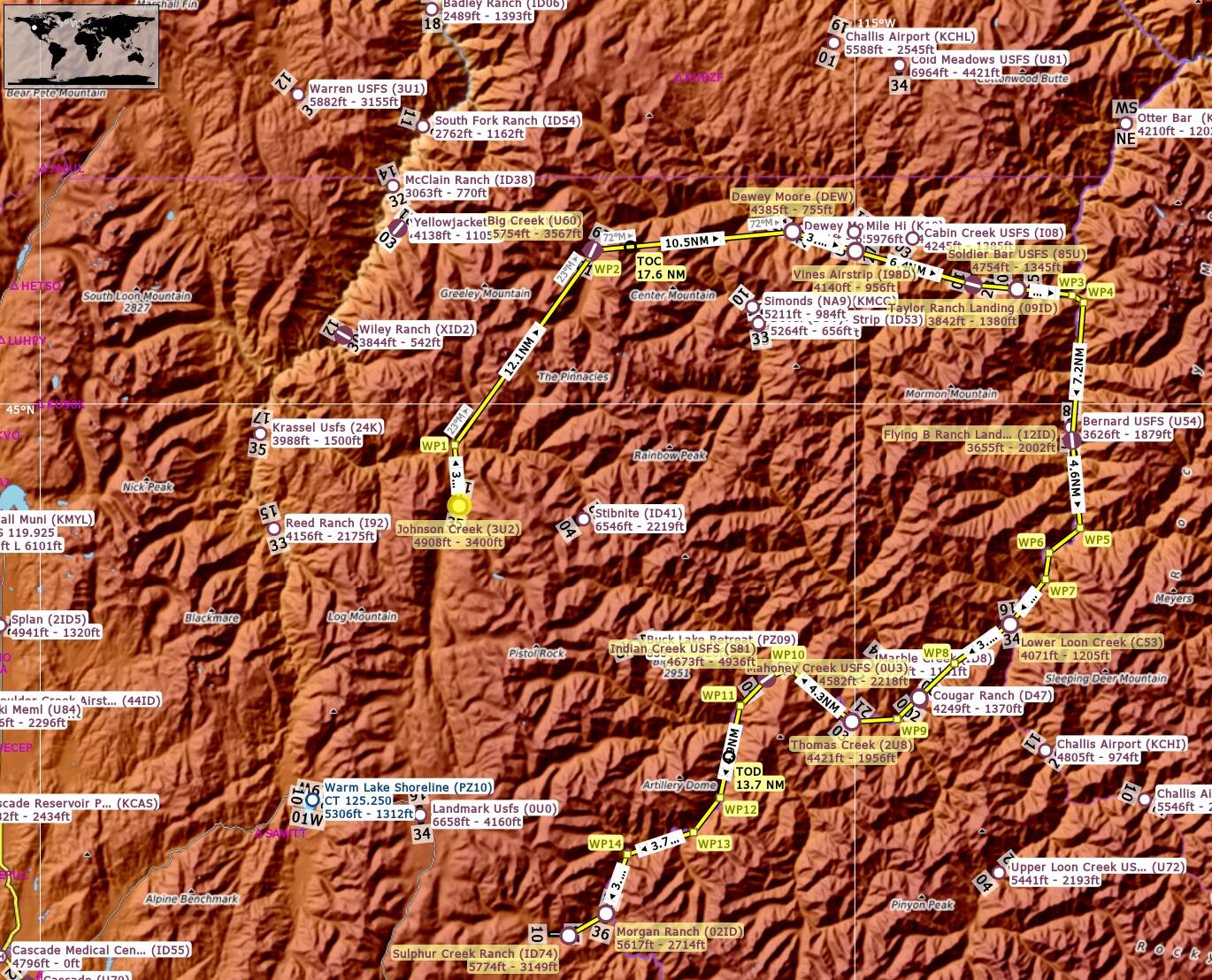
Johnson Creek (3U2) → Yellow Pine Township → Big Creek Lodge → Big Creek (U60) → Dewey Moore (DEW) → Vines Airstrip (I98D) → Taylor Ranch Landing (09ID) → Soldier Bar (85U) → Middle Fork Salmon River → Flying B Ranch (12ID) +++15‑min break+++ → Lower Loon Creek (C53) → Magoney Creek (QU3) → Indian Creek (S81) → Morgan Ranch (02ID) → Sulphur Creek Ranch (ID74)
 Highlights
- Big Creek, Dewey Moore & Vines — classic technical canyon strips
- Taylor Ranch, Soldier Bar & Indian Creek
- Middle Fork Salmon River canyon run
- Flying B Ranch rest stop
- Lower Loon Creek, Magoney Creek & Morgan Ranch
- Sulphur Creek Ranch finale
 Suggested Weather
Early morning or late afternoon, few clouds, light winds, visibility 30+ km.
Soft canyon light for depth, contrast, and formation flying.
If you are not a member, to join for FREE, click here: Aussie Group Flights Team - On-line Flying
Details to follow. Hope you can join us.
PLEASE NOTE: THIS INFORMATION IS FOR FLIGHT SIMULATION USE ONLY.
Regards, Paul
Event: Low & Slow: Idaho Backcountry Bush Cub Run
Sim: MSFS2024
Aircraft: Bush Cub
Speed: 100 knots
Server: South East Asia
Sim Time: 4:00pm
Route: See attached plan below
Alt: 10,500'
When:  Monday 13th April
Start: 19:00z
Duration: 1hr
Distance: 94nm


Take off from Johnson Creek(3U2)
Track 343 deg to Yellow Pine Townsite(WP1) 3.2nm
Track 023 deg to Big Creek(U60) 12.1nm
Track 072 deg to Dewey Moore(DEW) 10.5nm
Touch and Go at Dewey Moore(DEW)
Track 094 deg to Vines Airstrip(I98D) 3.4nm
Touch and Go at Vines Airstrip(I98D)
Track 093 deg to Taylor Ranch Landing(09ID) 6.4nm
Touch and Go at Taylor Ranch Landing(09ID)
Track 083 deg to Soldier Bar(85U) 2.3nm
Touch and Go at Soldier Bar(85U)
Track 084 deg to Middle Fork Salmon River(WP3) 2.9nm
Track along Middle Fork Salmon River to Flying B Ranch Landing Strip(12ID) 7.2nm
Full Stop Landing at Flying B Ranch Landing Strip(12ID) +++ 15 min break +++
Take off from Flying B Ranch Landing Strip(12ID)
Track along Middle Fork Salmon River to Lower Loon Creek(C53) 11nm
Touch and Go at Lower Loon Creek(C53)
Track along Middle Fork Salmon River to Mahoney Creek(0U3) 6.2nm
Touch and Go at Mahoney Creek(0U3)
Track along Middle Fork Salmon River to Thomas Creek(2U8) 4nm
Touch and Go at Thomas Creek(2U8)
Track along Middle Fork Salmon River to Indian Creek(S81) 5.6nm
Touch and Go at Indian Creek(S81)
Track along Middle Fork Salmon River to Morgan Ranch(02ID) 16.2nm
Touch and Go at Morgan Ranch(02ID)
Track 227 deg to Sulphur Creek Ranch(ID74) 2.3nm
Full Stop Landing at Sulphur Creek Ranch(ID74)

Airport Details:

Johnson Creek(3U2)
Elev: 4,908'
RW 17/35 Grass 3,400'

Big Creek(U60)
Elev: 5.754'
RW 01/19 Concrete 3,567'

Dewey Moore(DEW)
Elev: 4,451'
RW 10/28 Grass 755'

Vines Airstrip(I93D)
Elev: 4,140'
RW 09/27 Grass 956'

Taylor Ranch Landing(09ID)
Elev: 3,842'
RW 10/28 Asphalt 1,380'

Soldier Bar(85U)
Elev: 4,754'
RW 07/25 Dirt 1,345'

Flying B Ranch Landing Strip(12ID)
Elev: 3,655'
RW 18/36 Aphalt 2,002

Lower Loon Creek(C53)
Elev: 4,071'
RW 16/34 Dirt 1,205'

Mahoney Creek(0U3)
Elev: 4,582'
RW 04/22 Dirt 2,218'

Thomas Creek(2U8)
Elev: 4,421'
RW 03/21 Dirt 1,956'

Indian Creek(S81)
Elev: 4,673'
RW 04/22 Asphalt 4,936'

Morgan Ranch(02ID)
Elev: 5,617'
RW 18/36 Dirt 2,714'

Sulphur Creek(ID74)
Elev: 5,774'
RW 10/28 3,149'