ATTENTION Aussie Flight Group Participants …
PLEASE DO NOT SPAWN ON THE RUNWAY. ENSURE YOU SELECT THE STARTING POSITION ON THE RAMP.
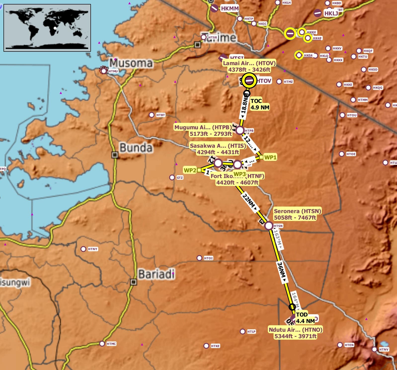
Route: Lamai(HTOV) Mugumu(HTPB) Fort Ikoma(HTNF) Sasakwa(HTIS) Seronera(HTSN) Ndutu(HTNO).
* Take off from Lamai(HTOV)
* Track 189 deg to Mugumu(HTPB) 18.8nm
* Touch and Go at Mugumu(HTPB)
* Track 140 deg to WP1 12.6nm
* Track 252 deg to Fort Ikoma(HTNF) 9.2nm
* Touch and Go at Fort Ikoma(HTNF)
* Track 273 deg to Sasakwa(HTIS) 7.2nm
* Full Stop Landing at Sasakwa(HTIS)  +++ 10 min break +++
* Take Off from Sasakwa(HTIS)
* Track 250 deg to WP2 7.6nm
* Track 104 deg to WP3 12.6nm
* Track 141 deg to Seronera(HTSN) 22nm
* Touch and Go at Seronera(HTSN)
* Track 163 deg to Ndutu(HTNO) 36nm
* Full Stop Landing at Ndutu(HTNO).
Airport details:
Lamai Airport(HTOV)
Elev: 4,378’
RW 09/27 Asphalt 3,426’
Mugumu Airport(HTPB)
Elev: 5,173’
RW 11/29 Grass 2,793’
Fort Ikoma Airport(HTNF)
Elev: 4,420’
RW 09/27 Dirt 4,607’
Sasakwa Airport(HTIS)
Elev: 4,294’
RW 12/30 4,431’
Seronera(HTSN)
Elev: 5,058’
RW 13/31 Grass 7,467’
Ndutu Airport(HTNO)
Elev: 5,344’
RW 05/23 Asphalt 3.971’
Event details:
Altitude: The route can be flown up to 7,500’ to be clear of terrain.
Aircraft: Strongly suggest a helicopter for this event, so you can hover and view the many points of interest.
Suggested Cruise Speed: 120knots
Server: South East Asia
Join Discord Server: Discord
Note: Joining the Discord Server is FREE. As a member it allows you to enjoy many services the site has to offer. You also use the Voice capability of the Discord server to chat during events.
Depart Time: 20:00z
Sim Time: 08:00am
Multiplayer: All Players
Weather: Live Weather
Flight Duration: 1 hr 15 min approx.
Flight Distance: 126nm
Flight Plans to support the event …
Little NavMap:VFR Lamai Airport (HTOV) to Ndutu Airport (HTNO).lnmpln (2.5 KB)
MSFS: VFR Lamai Airport (HTOV) to Ndutu Airport (HTNO).pln (3.4 KB)
Flight Card: Click Here