ATTENTION Aussie Flight Group Participants …
Group Flight: 2022-10-23T09:00:00Z
PLEASE DO NOT SPAWN ON THE RUNWAY. ENSURE YOU SELECT THE STARTING POSITION ON THE RAMP.
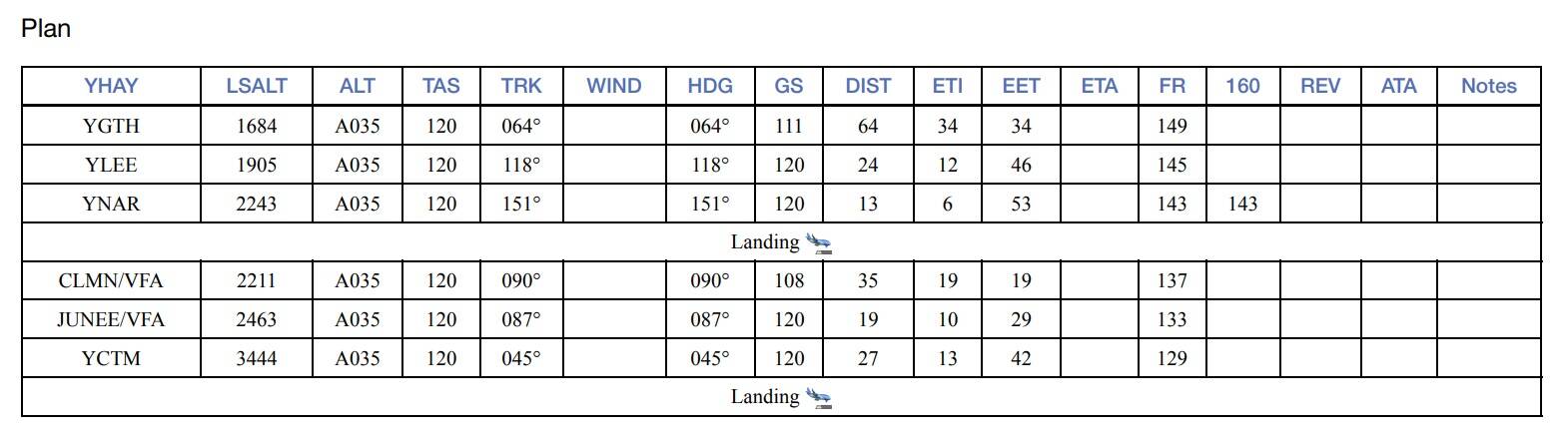
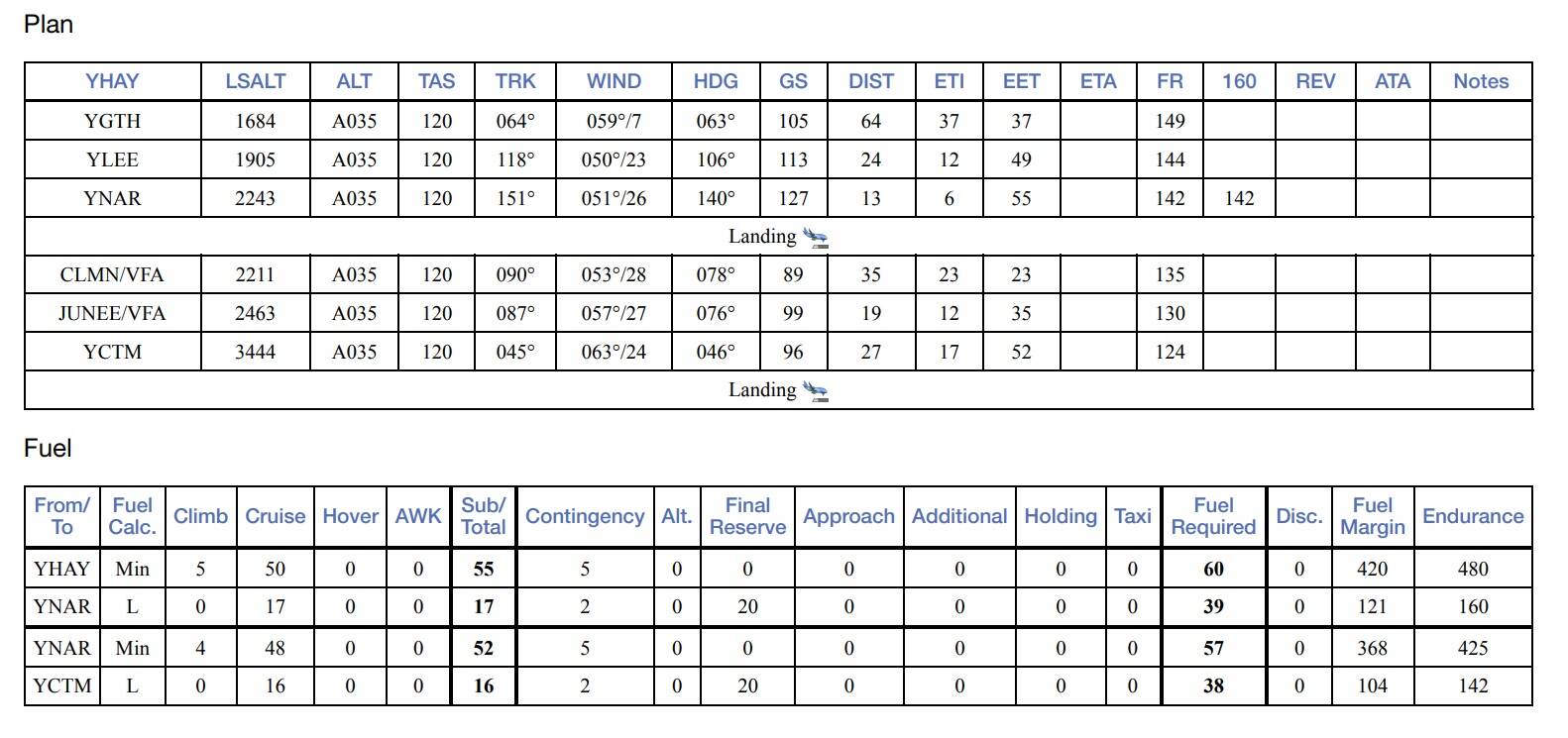
Route: YHAY YGTH YLEE CLMN JUNEE YCTM
NOTE: Below tracks are course directions only. I will provide heading information based on winds aloft prior to the flight.
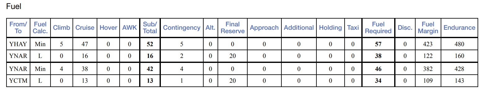
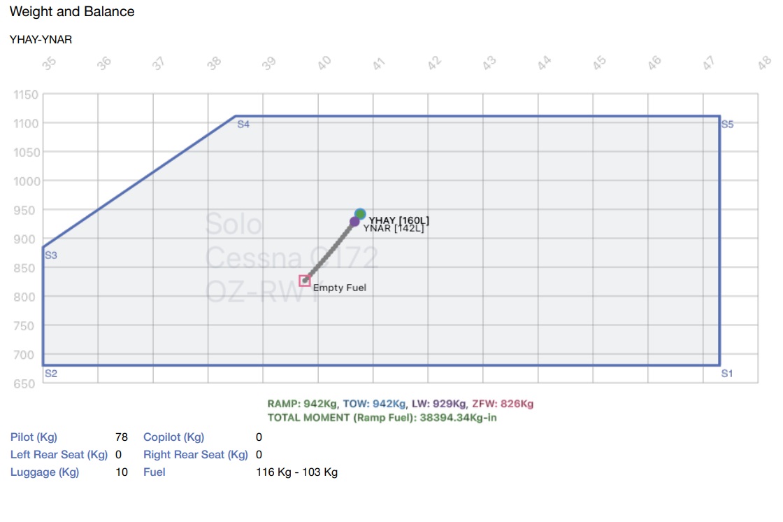
Take off from Hay(YHAY)
Track 064 deg to Griffith(YGTH) 64nm
Touch and Go at Griffith(YGTH)
Track 117 deg to Leeton(YLEE) 24nm
Overfly Leeton(YLEE)
Track 153 deg to Narrandra(YNAR) 12.8nm
Full Stop Landing at Narrandra(YNAR) +++ 10min Break +++
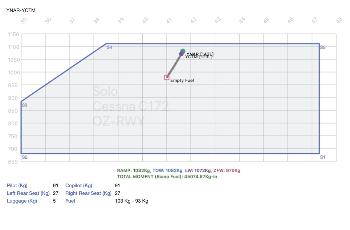
Take off from Narrandra(YNAR)
Track 090 deg to Coolamon(CLMN) 35nm
Track 087 deg to Junee(JUNEE) 19.1nm
Track 045 deg to Cootamundra(YCTM) 27nm
Full Stop Landing at Cootamundra(YCTM)
Altitude: The route can be flown up to 3,500’ to be clear of terrain.
Airport details
Hay(YHAY)
Elev: 305’
RW 04/22 Asphalt
RW 15/33 Dirt
CTAF: 126.70
Griffith(YGTH)
Elev: 439’
RW 06/24 Asphalt
RW 18/36 Dirt
CTAF: 126.55
NDB: 305
Leeton(YLEE)
Elev: 475’
RW 05/23 Grass
RW 11L/29R Grass
RW 11R/29L Grass
RW 04/22 Dirt
CTAF: 132.85
Narrandera(NAR)
Elev: 474’
RW 14/32 Asphalt
RW 04/23 Dirt
CTAF: 132.85
Cootamundra(YCTM)
Elev: 1,110’
RW 16/34 Asphalt
RW 10/28 Grass
CTAF: 126.7
For airport comprehensive airport details refer: Aeronautical Information Package - Airservices.
The information is available under the latest ERSA. Simply search for the airport.
Aircraft: C172
IMPORTANT: In the interest of keeping it REAL, please refrain from selecting inappropriate aircraft, like airliners. This only detracts from the immersion of the flight.
Seeing Aircraft Correctly: You need to do two things to ensure you can see the other pilots in the event and see them in the aircraft they selected.
Select the same environment: To do this, proceed as follows:
Use VPilot to connect to VATSIM
Use the FSLTL for model matching.
FSLTL is an AI Traffic product that is FREE. It also supports VATSIM model matching. For details, watch this video: MSFS | FSLTL - New VATSIM Model Matching Out Now - Full Tutorial! - YouTube
Set Traffic options: To do this, proceed as follows:
From the Welcome Screen, click on OPTIONS
Click on GENERAL
With TRAFFIC selected:
Set Aircraft Traffic Type to OFF
Set Ground Aircraft Density to 0
scroll down to the last option and set USE GENERIC PLANE MODELS to OFF
Here is a tutorial on setting up MSFS for use on VATSIM: How to set up Microsoft Flight Simulator 2020 for VATSIM [3min Tutorial] - YouTube
Turning off Crash/Damage:
Select Options/Assistance
Expand Failure & Damage
Disable Crash Damage
Disable Aircraft Stress Damage
Disable Engine Stress Damage
Accept the changes
Voice Room: My personal Discord server is used for voice comms. If you haven’t already joined my server, click on the below link to request access. I will set you up as a Member so you can access the server. Ensure you do this prior to the flight, as latecomers will need to wait for the next event.
Link to join the Voice Room: [Aussie Group Flights Team - Aussie Group Flights Team - On-line Flying
This is useful for general chat and briefings etc.
Note: this link is only valid for 7 days from posting.
Weather/Time: We will set the time to 8am. This will allow us to fly in daylight and choose REAL weather so that the winds are correct.
From the World Map view, click on Flight Conditions (upper right of screen)
Set Multiplayer to OFF, Air Traffic to OFF and Weather and Time to CUSTOM.
Under Weather and Time on the right, select Live Weather and move the time slide bar to show 8:00am.
Click Close and Fly from the World Map view.
We can start departing from 09:00z.
Let me know if there’s anything else that I’ve missed that you need to know.,
Regards, Paul