Group flights, Aussie style. Aussie Group Flights Team is the ultimate way to explore the world with your favourite people.

Series S9.T2 — Cold War Jets in “Route 66 Revisited”
Briefing Card — Flight S9.T2.F4
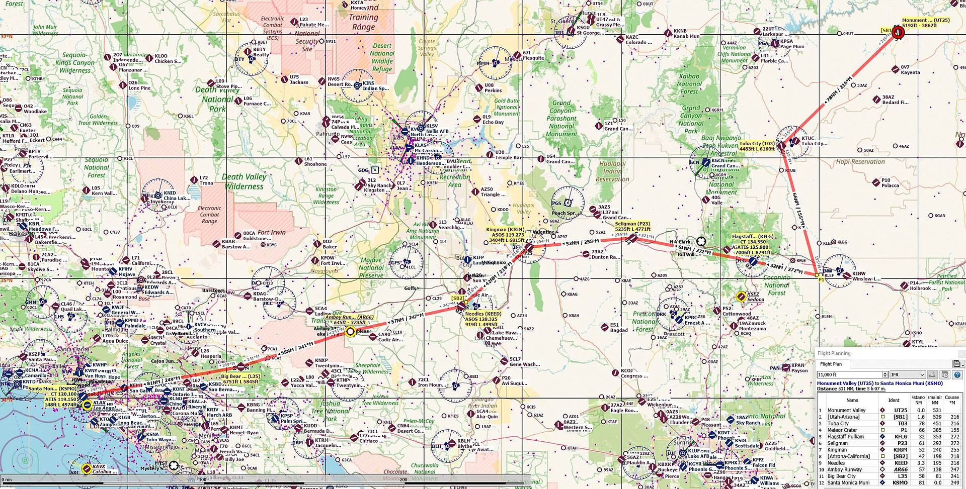
Monument Valley (UT25) → Santa Monica (KSMO)
This is the fourth and final flight of Series S9.T2, taking us from Monument Valley (Utah) to Santa Monica (California).
A mid‑flight LFS coffee break will be taken at Kingman (KIGM) in Arizona.
Required cruise true airspeed: 300 kt (345 mph / 556 kph).
Total flight distance: 531 nm.
Flight time: ~107 minutes, plus ~15 minutes for the coffee break.
More detailed routing is available in the associated lnmpln and pln files.
Route Summary
PORs, Airfields & POIs (T&G except where noted):
-
UT25 – Monument Valley (Take‑off)
-
[SB1] – UT/AZ Border
-
T03 – Tuba City (T&G)
-
P1 – Meteor Crater (POI)
-
KFLG – Flagstaff Pulliam (T&G)
-
P23 – Seligman (POI)
-
KIGM – Kingman (LFS Coffee Break)
-
[SB2] – AZ/CA Border
-
KEED – Needles (T&G)
-
AR66 – Route 66 Airfield (T&G)
-
L35 – Big Bear City (T&G)
-
KSMO – Santa Monica (LFS Destination)
Leg Distances, Tracks, Times & Altitudes (Zero‑Wind)
-
UT25 → SB1 — 2 nm — 216° — 1 min — 7000 ft
-
SB1 → T03 — 78 nm — 216° — 16 min — 9000 ft
-
T03 → P1 — 66 nm — 155° — 13 min — 6000 ft
-
P1 → KFLG — 32 nm — 272° — 6 min — 9000 ft
-
KFLG → P23 — 61 nm — 272° — 12 min — 9000 ft
-
P23 → KIGM — 52 nm — 255° — 11 min — 7000 ft
-
KIGM → SB2 — 34 nm — 218° — 7 min — 5000 ft
-
SB2 → KEED — 57 nm — 218° — 11 min — 5000 ft
-
KEED → AR66 — 57 nm — 247° — 11 min — 4000 ft
-
AR66 → L35 — 58 nm — 241° — 12 min — 8000 ft
-
L35 → KSMO — 81 nm — 249° — 16 min — 8500 ft
Total Distance: 531 nm
Total Time: 107 min (zero‑wind)
Key Locations
Departure
UT25 – Monument Valley, Utah
Coffee Break (LFS)
KIGM – Kingman, Arizona
~15‑minute stop
Destination (LFS)
KSMO – Santa Monica Municipal, California
Flight Profile
-
Altitude: 4000–9000 ft (QNH), descending at pilot discretion
-
Weather: Real Time / Live Weather if possible
-
Navigation: Dead Reckoning using LNM map, DI/compass, watch, and ground features
-
State Transitions: UT → AZ → CA
-
POIs: Meteor Crater, Seligman, Route 66 landmarks
Aircraft Requirements
Any single‑engine jet (SEJ) warbird capable of maintaining:
-
Cruise speed: 300 kt
-
Velocity: 5 nm/min
-
Typical aircraft: Hawker Hunter, F‑86 Sabre, MB‑339A, T‑33
Fuel Planning (including 30‑min reserve)
Formula: F% = (T + 30) / E, rounded to nearest higher 5%
-
Hawker Hunter F6:
E = 2.0 min/% → F% = (107 + 30) / 2.0 = 70% -
Lockheed F‑86 Sabre:
E = 2.0 min/% → F% = (107 + 30) / 2.0 = 70% -
Aermacchi MB‑339A:
E = 2.8 min/% → F% = (107 + 30) / 2.8 ≈ 55% -
Lockheed T‑33:
E = 1.3 min/% → F% = (107 + 30) / 1.3 ≈ 105% → 100%
Warning: Only ~23 minutes of reserve available.
If you are not a member, to join for FREE, click here: Aussie Group Flights Team - On-line Flying
Details to follow. Hope you can join us.
PLEASE NOTE: THIS INFORMATION IS FOR FLIGHT SIMULATION USE ONLY.
Regards, David