Barometric Altitude (MSL) vs. "Actual" Altitude (MSL)

I’m a bit of a stats nerd, so be prepared for a bit of a long explanation here.
I’m not sure how much credence can be placed on the old “Shift + Z Stats” program, but I’m thinking it’s accurate enough in the large scheme of things, that this question is worth asking:

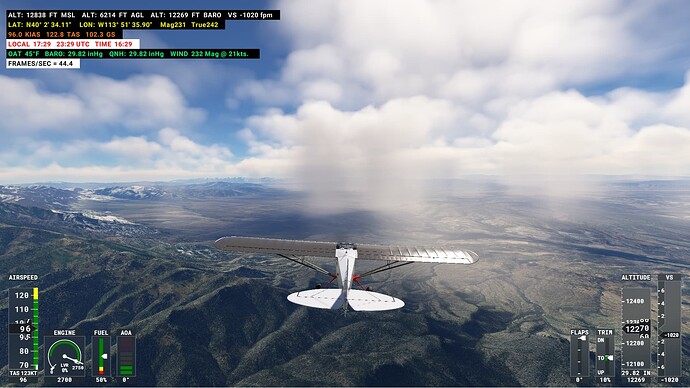
In this image, I’m flying near the Utah/Nevada border, and the “actual” barometric pressure is 29.82" Hg, and I set my QNH to match, also at 29.82.
(This indicated by the green numerals 5th line down).

The top line with white numerals are my altitudes, and note that my “actual” MSL Altitude (first value on the far left) is 12,838 feet. My barometric altitude (3rd value from the left) reads 12,269 feet. That’s a difference of 569 feet.

My question (after all that )… is why don’t those altitude readings match, if the QNH matches the actual barometer? If the plane is sitting still on the ground before takeoff, or after landing, those two altitude readings WILL match.

Does the difference come into play when the plane is in motion? Does air rushing into the pitot tubes affect the baro altitude reading?

Thank you.

Hi,

I try to describe it basically although I don’t know nothing about that data source (some 3-rd party app???).

Answer is easy - change of altitude with different pressure reference data. It means that I have one altitude available due some let say ATIS info where QNH is reported for correct altimeter set and to be corrected/calibrated. Next altitde is typical rule - change of pressure with altitude, this is simply live altitude that change depended actual pressure at your actual position, not depended to previous pressure reference. I think that this is basic description for what you’re asking.

Thank you sir. So I think what you’re saying is that QNH altitude refers to a reported pressure from the nearest airport below, but that the actual altitude is what is variable – when I’m simply traveling between two reporting stations.

eeeeeehm :slight_smile:

ok, look. If you set on your altimeter some pressure as calibration data source (from ATIS as example) your altimeter will show altitude only corrected to this pressure. That next ‘live’ altitude changes with different pressure at actual your position and altitude and has nothing to do what you have set on your altimeter. This is how I understand this because with travel and moving, pressure changes logically :slight_smile:

Ok, I think that basic test can be if you’ll do this. Fly and look as your data changing with position. At specific moment, click B key what is set pressure to altimeter at actual position. At this moment I expect same altitudes until you’ll not go to different pressure place :slight_smile:

Simply this is typical example why LOCAL airport pressure is required to have correctly set on altimeter and also after passing some transition altitude to have STD pressure set on your altimeter - SAFETY first so all we have same data and not have collisions with others or terrain :wink: I think that I can agree with your last words definitely :slight_smile:

and has nothing to do what you have set on your altimeter

…but altitude can be same if both pressures are same at the moment :slight_smile: Yes, we are mostly at situation and habit that ATC or ATIS have reported some data and we don’t care about basic things, what is behind that. This can go to fatal situation of course…

Interesting topic that I’ve also wondered about.

My thought (please tell me if I’m wrong) is that there are only two scenarios in which knowing a precise AGL - which when airborne is approximated by barometric altitude unless the aircraft has a radar altimeter - is critical.

  1. Landing. Obviously you need to know your actual height above the runway. This data is provided by the destination airport.
  2. ATC altitude assignments. When based on barometric calculations it’s never precise.

When I’m flying VFR a difference of a few hundred feet due to an imprecise barometric altitude at my exact location is pretty irrelevant (and practically unavoidable.)

This would explain why AI traffic never cruises at my altitude, even though we are on the same flight level. It seems they are cruising at MSL altitude while the player is on STD barometric altitude.

1 Like

I can be wrong with understanding more things with his situation and data he has.

QFE/AGL/MSL.

With AGL I can only look at my radar altimeter if I have it. I can count with actual pressure I have from the station airport but this is wrong to me to do that, on other side I can’t imagine why to do this.

  1. My thought (please tell me if I’m wrong) is that there are only two scenarios in which knowing a precise AGL - which when airborne is approximated by barometric altitude unless the aircraft has a radar altimeter - is critical.

Agree, very critical. My answer also here just an agree statement, generally.

  1. Landing. Obviously you need to know your actual height above the runway. This data is provided by the destination airport.

What data depends to type of approach, in my opinion.

  1. ATC altitude assignments. When based on barometric calculations it’s never precise.

hmmmm ok but I see this like no problem because with approaching airport, you’re at some quite safe altitude for start to go down. Set different pressure than ATC/ATIS reported is your hazard still but this can be more huge problematic, depended to more things.

  1. When I’m flying VFR a difference of a few hundred feet due to an imprecise barometric altitude at my exact location is pretty irrelevant (and practically unavoidable.)

I think same as my answer on point 3. Simply one example what also is ok with your thought. Imagine you’re not one reaching entry point to CTR under VFR. You need f.ex. hold on VRP at some altitude but then 2 other aircraft will reach also. Every one from you will have same conditions, same QNH already set due ATIS on board but all of you need have own visual separation to be safe. Play here role of exactly precise altimeter set +/- or not? :slight_smile: Imagine that situation, especially you’re under TMA for CTR entry…

Altimeter settings are always given in units corrected to sea level pressure. That’s what you use to set your altimeter and it gives you an MSL altitude accordingly.

But unless the airport is at sea level that’s not the actual air pressure. The actual air pressure decreases with altitude, as you’d expect. The trick is the altimeter has a set of sealed aneroid wafers that are permanently calibrated to sea level pressure, but surrounding those, in the altimeter case, the pressure varies with the pressure coming in from the static port and the wafers expand and contract, pushing on a geared mechanism that drives the altimeter needles.

If the altimeter wasn’t adjustable (always standard), we could just read our altitude straight off the altimeter face all day and we’d mostly avoid each other by flying assigned altitudes alone. This is what we do when we set it to “standard,” (29.92 in the US), and the altitudes displayed at that point are known as pressure altitudes. This works above 18,000’ in the CONUS because there’s nothing to hit up there (and there’s various margins built into that).

However, because pressure/weather systems move about, the static pressure is always in flux and causing our indicated altitude to change. A mis-set altimeter could run us into terrain and obstacles, the elevations for which are a known geometric quantity. Thus, we have the ability to adjust our altimeter with the kollsman window to a localized altimeter setting, relative to adjusted sea level pressure. If we (are able to) instead adjust the kollsman window to the actual outside static pressure, it would read zero. If did that while sitting on the airport, we could use that to derive AGL altitude, but it’s not recommended outside of very limited and controlled cases (like some aerobatics). But wait, there’s more…

The initial premise that @b3burner is describing is likely due to the way the atmosphere expands and contracts due to heating. So while your geometric altitude might be, say 9,000 MSL, on a hot day the atmosphere expands and the pressure altitude (relative to sea level) of 9,000 might actually be above the geometric altitude of 9,000, even with a correct and current local altimeter setting. This is because the column of air is stretched out and you have to go farther up, geometrically, to get to the same density.

Therefore in that case you have to climb higher than 9,000 to read 9,000. This gives meaning to the adage “low to high, you’re in the sky,” which applies to both ambient pressure and temperature changes. This can have a very detrimental effect when it is extremely cold, when the inverse occurs. In that case, the atmosphere is compressed, isobaric (same) pressure levels lowered, and for your altimeter to read 9,000’, you might actually have to fly below the geometric altitude of 9,000. As you might expect, this can have major implications on terrain and obstacle avoidance. So much so that instrument approaches into designated “cold weather airports” have limitations and altitude corrections that have to be manually applied (if you don’t have a system that compensates for the temps).

Tl;dr, the ambient temperature is probably causing the discrepancy
8 Likes

Thanks for that detailed explanation. One of the things I like best about this sim is that it has resulted in a really well-run forum with some really smart and experienced members from whom I am learning a lot.

2 Likes

Thank you for everyone’s assistance. I do believe that answers my question.

Don’t forget the Baro is set at an airport…so that the height of the runway is correct on the altimeter.

Airliners will use inertial navigation, GPS and radar to determine height accuratly.

But their standby instruments will have a Barometer setting, for safe landing if other systems fail dramatically.

While airliners do have GPS and IRS that let them calculate geometric altitude, they are not using that for their primary altitude display, that is clearly still the pressure altitude as you can see by changing the QNH and watching your primary altitude display change.

I’m sure the reason they do this is for consistency with other users in the sky. It’s no good if your airliner is using geometric altitude while the one going the other way is using pressure altitude, you might be on different assigned flight levels and still crash.

It would be interesting to know if airliners are using pressure altitude or geometric altitude to calculate height above terrain when it comes to the terrain maps. Obviously the GPWS itself is using the radio altimeter which is measuring true height.

1 Like

EDIT ON/

I actually thought that EGPWS only used GPS altitude. From a little research, it appears I was incorrect. EGPWS (at least in some installations) uses an algorithm blending all available inputs in order to determine the “most accurate” height above the terrain model.

Second edit: The more I read into systems other than my own, the more EGPWS appears to have in common with FMS, which are highly individual
though they appear to all do the same thing…just not the same way. :thinking:

EDIT OFF/

1 Like

Above typically 10,000ft airliners assume STD pressure - so pressure changes won’t affect flight paths during cruise.

Transition altitude varies by country. It’s 18,000’ in the US because our highest peaks in the lower 48 only get up to just under 15,000, and with the buffer for obstacles and various errors, being at or above FL180 basically guarantees you won’t hit any terrain. In fact, the only terrain you’d hit in the entire US is Denali, and that airspace is handled positively and a bit differently.

Roger on the details - thanks. I’m in the UK so heights are different.

I was just trying to say that at cruise levels air pressure is effectively ignored; apart from a serious failure in ADIRS.

Here’s an excellent article about the differences between actual, pressure, calibrated, and density altitudes.

1 Like