Hey guys, can’t tell if this is a bug or some weird feature of the G1000 in the 172. Also confirmed it in Baron 58. When selecting a NAV bearing (bearing 1 or bearing 2), if it’s an ILS or LOC, the g1000 seems to refuse to show an arrow. but it will show an arrow for a VOR as Nav1 or Nav 2.
Seems like it would be a weird feature to have in the G1000 if you’re depending on using both NAV radios to find the IAF; like you’re flying down the radial of the VOR to the IAF and would be nice to see the second Nav arrow point at the correct ILS course at the right spot, but it doesn’t because no arrow.
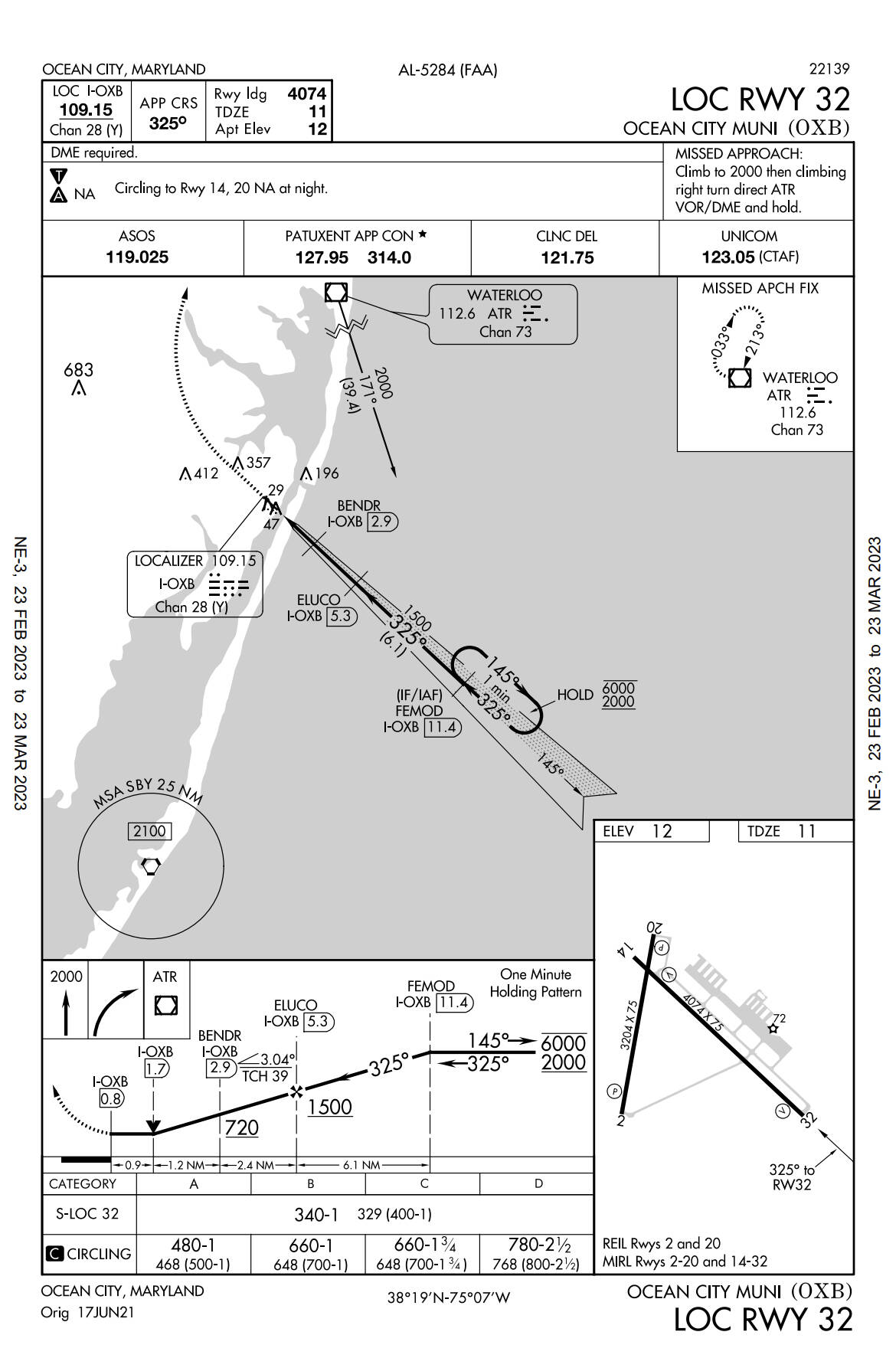
So, is this a bug or a feature of the G1000? You can test by going to KOXB and setting the LOC frequency, 109.15 and the waterloo VOR (ATR) 112.6 and you’ll notice no arrow for ILS but arrow for VOR on both NAVs.
thoughts?
Oh, one other thing. If you use the full external nav aids, you’ll get 2 arrows on the HSI when in external view. I wonder what that’s based on…?
A VOR has a much longer range versus an ILS. Maybe you’re not close enough to the ILS for it to be active. How far away are you when trying to capture the ILS?
This is by design and matches real G1000 behavior. The bearing pointers only work for GPS waypoints, VOR stations and ADF beacons. These things all correspond to specific places on a map, and more importantly, there is a way for the aircraft to determine what is the exact bearing to that place from the current aircraft position (assuming necessary radio reception).
ILS (or more specifically, the localizer) is not like that. Think about it as a single radio beam, that can be received only within a relatively small “cone” to the left and right of this beam. If you are outside of that cone, there is no way to determine where the source of the beam is, no matter how close you are. That is why the bearing pointers do not work for the localizer.
While i do understand the idea when not down the beam of the localizer, one would think that if you are in the beam, then the g1000 could give you an arrow at that time so that you can know it’s ok to switch from the Nav1 radial to the Nav2 localizer.
With this feature, you don’t get a nice little X marks the spot for the iaf. So what I did at KOXB was fly the outbound radial, 171 from ATR (Waterloo) as Nav1 as “bearing 1”. Then I used the ADF/DME button to set the DME button on the PFD to NAV2 which i set to I-OXB frequency, and flew until Nav1 bearing said 39.4 and the DME said I-OXB said 11.4 then switched to Nav2 and did a little circle to join the Localizer.
Just seems inefficient to need to use indirect DME, or rather, why is dme ok to use, but not an arrow pointing at the runway?
As long as it’s a feature, ok. Just seems like, if i didn’t have a chart with precise DME readings or if the localizer didn’thave DME, how would you find the ILS? I guess you could fly heading mode on the outbound from the VOR while setting your NAV to the localizer, and just wait that way..?
One more question. I couldn’t find the answer online. Maybe you or some else knows: i was flying with a streamer to KPNS, prior to the koxb flight, and wanted to follow the inbound VOR radial 070 on CEW VOR.
I first locked on it using NAV1 and it was fine, straight green line. But i wanted to try GPS OBS (never used it before).
So i did Direct to CEW on the MFD and when I set the OBS to 070, i noticed that while it did point straight at the VOR, OBS DTK was miles to my right (i was west of the VOR). Why might VOR mode and OBS mode give different courses? Is one magnetic and one true heading? Or do i just not understand G1000 OBS? Yesterday was the first time i ever seriously tried it.
Hmm, i just remembered that late last night I noticed some of my settings got reset and one had gyro drift on. I wonder if that’s it. But we were only flying around for 30 minutes at that point. I’ll try again with drift off, if that could make a difference.
You might double check the direct-to setting. If you’re west of the VOR, and go into “direct to” and set the “CRS” to e.g. 70, it will just reset the course to the direct bearing when you activate it. You’ve asked it to do a direct bearing, so it won’t let you change it.
However, when you go into OBS mode, and change the course to 70, (given that you were on whatever the direct-to bearing was), you have to now go toward the 070 course line, which will be quite a ways off, since now you actually want to track the 070 radial (vs whatever the actual radial was for “direct-to” mode).
Regards
GPS waypoints (including navaids) and courses are geometrically derived using up-to-date magnetic variation data.
VORs are calibrated at the ground equipment - setting the 000 radial to whatever mag north is at that time, and recalibrated much more rarely. Magnetic variation changes in the ensuing time and results in a discrepancy between GPS course and VOR course, sometimes by several degrees.
If I may add, when considering the principle of operation of localizer versus VOR, the VOR is constantly sending out a stationary signal along with the rotary signal. This allows the receiver to constantly compare electronic phase and using the OBS, select which phase (radial) they desire to navigate.
But also, in constantly providing phase and thus radial information, an RMI indicator (the arrow OP speaks of) always “knows” where the station is.
A localizer is a completely different modality, using two fixed signals along a predetermined path. When the receiver detects that those signals overlap, the CDI is centered. But, as you say, it doesn’t give radial position.
This is completely normal for instrument approaches. Your way works. The way I’d do it is as follows:
Tune I-OXB in NAV1
Set CDI 1 to the inbound course of 325
Set the DME to read NAV1 only
Do not put this in BRG1
Tune ATR in NAV2
Switch the CDI to 2 and set the outbound course of 171
Put ATR in BRG2 (this will give you distance info)
When you get within a mile or two of the fix (FEMOD), switch the CDI back to Nav 1. At this point, you’ll be looking for the localizer needle to “come alive”, and from here on out, you’ll be following that only. You can keep ATR in BRG2 because you will need it if you go missed approach.
When you intercept to the localizer course at FEMOD, you’ll need to turn outbound (left) and fly the procedure turn (PT - in this case, a holding pattern in lieu of procedure turn or HILPT). Once you re-establish the inbound course after the PT, you will be using only localizer and DME from NAV1 for position information.
On some approaches it gets even more fun when you’re getting DME from yet another VOR because the localizer doesn’t have a DME. So you might have a feeder VOR (like this approach), then have to change to a different VOR in NAV2 and DME while being on the localizer in NAV1 during the actual approach.
@CharlieFox00 described very well how to “find” the localizer and fly a localizer approach using traditional radio navigation only.
With a IFR-certified GPS like the one that is part of G1000, you can also “cheat” (and in practice, you almost always do). That is, you load the approach into the flight plan, and navigate using GPS till you are established on the final approach course. Only after that you switch the guidance (CDI) to the localizer. Even better, if you set it up right, and have the localizer frequency already dialed as NAV1 active frequency, the G1000 will do the switch to localizer navigation automatically.
Yes, and parts of that aren’t cheating at all. It is absolutely okay to use GPS for lateral guidance to fixes on an instrument approach. Some ILS approaches even require it! There are some additional monitoring requirements on VOR with no GPS overlay (but those are getting more and more rare).
Anyway, it’s only the final course guidance on a localizer-based approach that requires “green needles” (NAV/LOC) mode versus magenta (GPS).
Here’s a good example: the ILS Rwy 28R into KOAK in which GPS is required (in the absence of radar vectors). BBUBB and CYMBL are the only IAFs on this approach and both are RNAV waypoints with no other means to identify them.