Last night I was flying north towards Cairns YBCS in the DA62. I know how to tune to local weather to find the active runway but don’t know how to choose the appropriate approach procedures from the list on the glass cockpit. The one I chose had me fly about 10nm north then make a 170 degree turn on a dime for approach. This seems very unrealistic to me. So how do I know which approach to choose? Is it just through local knowledge or is there something I can be looking at? I had a look on skyvector but my untrained eyes couldn’t find anything. Any help would be great. Thanks.
Use Little Nav Map.
It gives you many things, but among them, a top down view of an airport’s approaches relative to your current position.
Most approaches have full transitions - usually these are oriented to give inbound planes arriving from different directions a choice of a nearer point at which to descend and begin an approach into a field’s specific runway.
There’s also STARs, which are essentially highway off ramps. Bigger airports have STARs to route inbound aircraft safely given the larger volume of traffic. STARs hook into approaches, but pick an airport that has approaches only first to get used to the flow.
4 Likes
Thanks very much.
Once you know the active runway, you can choose which ever approach you like. Normal convention is to choose the most accurate, so ILS first, RNAV, VOR etc, but you can request whatever you like for practice or due to equipment limitations.
Most approaches have multiple initial approach fixes (IAF), and you would select this based on the direction you are coming from. It’s easy to see this if you have access to the appropriate charts. Below is the ILS chart for YBCS, with the 4 IAFs identified. I assume you flew the approach either from CS (blue IAF) or started at GUNRO (yellow) and hence did a 180° at this point.
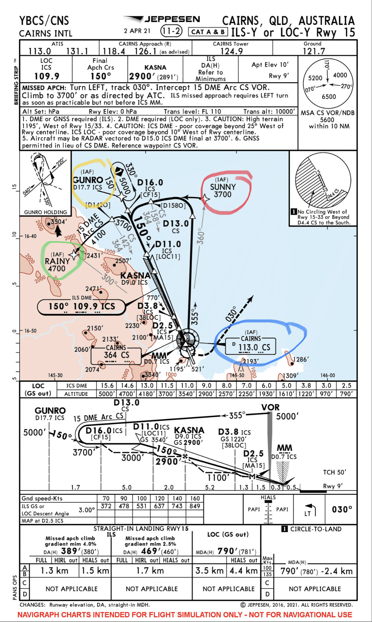
Note: Most avionics also allow you to omit the IAF entirely, this is most useful when under radar vectors for the final approach course. If you did not select an IAF you may have actually commenced the approach much closer in at D16.0 or even D11.0 (CF15 or LOC11 respectively should be the waypoint name in the gps).
When coming from the south, RAINY or SUNNY are the normal IAFs used in Cairns.
1 Like
Correct GUNRO was the approach I flew. Is there somewhere I can find these charts online?
All Australian charts are available for free from the Airservices Australia website below. Simply select “I agree” at the bottom of the page, then “Departure and Approach Procedures” then “Aerodrome and Procedure Charts”.
The format of these charts are different to the Jeppesen chart above.
Alternatively, a Navigraph chart subscription will give you Jepp charts for everywhere in the world.
Thank you. I’m so in over my head atm, but also paddling ever so slowly back to the surface.
2 Likes
If you fly in US, skyvector.com is a good resource
Forgive my ignorance, but I can’t find any approach procedures on skyvector
click the airports icon at the top of the page.
Then type the airport 4 letter identifier into the search box on the next page.
K for continental US. P for Pacific
KJFK = New York Kennedy
KIAD = Dulles
PHNL = Honolulu Hawaii
PANC = Anchorage Alaska
Then scroll down to Approach PDFs. They’re at the bottom after the airport data.
Thank you.
I highly recommend a subscription to Navigraph if you’ll be flying in multiple places around the world frequently as opposed to a single location. It is very affordable and has great charts and features, and include tablet apps as well in the ultimate tier.
Very worth it if you expect you’ll be at this for a while and makes your life much easier when at the flight planner making your IFR legs.
Cheers
I’ve already decided to do this. I’m in the process of flying around the world as a part of my learning process. I started in the xcub in the far south of Tasmania. As I didn’t actually realise how big Australia is, I’ve now changed to the DA62 as of the Whitsundays. Due to the help I received from earlier replies I’ve got Australia and the United States covered. I will be subscribing to navigraph as of tomorrow. I’m leaving from Mapoon tonight (cape York peninsula) to fly across the Torres Straight and onto PNG. So I’m going to need the charts to help learn and to keep it as real as my very inexperienced brain possibly can.
Thank you all for your help.
3 Likes
Nice! I used to fly into Mapoon & Wester PNG regularly IRL. Watch out for the weather in PNG, small puffy Cu clouds turn into huge nasty CBs in what seems like only a matter of minutes up there. Saying that, it’s probably some of the most fun, challenging and rewarding GA flying you can do anywhere on earth.
Enjoy the trip👍
The closest I’ve ever come to that area is Weipa. My best mates family own quite a large wholesale nursery. When we were younger, his father took him and I on chartered fishing trips once a year for about five years. It’s one of my best set of memories, the difference between Sydney and Weipa cannot be put into words. From memory, there was one pub hat was only open for take away one day a week!! Nothing but nothing, scattered amongst beauty up there. I’d happily leave most everything behind and move to one of these places, colder would be more my thing though. If only I could convince the boss it was a good idea!!
1 Like
Approaches use navaids or intersections for the initial fix (IF) called a “transition “. You need to choose the IF closest to your flight path otherwise you may have to fly a long time to reach a fix. Or if the IF is behind you, you’ll have to fly away from the airport. If possible and if close enough, try to choose an approach without specifying a transition.
Sites for charts mostly USA. Skyvector, airnav are two. FAA.gov - has sectional charts, and lots of other data to use, got to hunt for it. PMDY is a great location to practise TO and Landings, no navaids except approach lights on Runway 24. But excellent place no traffic, so open skys for you.
i’m also having trouble understanding how to select an approach as well.
I get the impression that you can try to pre-plan a landing approach in real life, but ultimately its down to air traffic control what you use. I’m lead to believe they will let you know which approach your using over the radio, so you can tune them in. Is that correct?
I guess on flight sim, its just all up to you. the in game landing transition picker on the map seems very buggy to me. I tried flight planning on simbreif today, and that seems to plot and set your landing transition based on real-world flying and other flights that have landed recently. It seems like a much better option so far to me. Not tried little nav yet.
Being at risk of giving incorrect advice, but this is what I’ve been doing. At monitored airports I tune the radio via ATC to the information frequency, this gives weather and the active runway. Then via the glass cockpit I go into flight procedures and choose approach. You then are able to program what runway and approach procedure you want to use. Finally activate the approach and it updates your nav data. For smaller airports I’ve just been selecting the runway closest to my approach heading. If you look up above there’s a pic of one of the charts for Cairns airport. He also highlighted the different approaches you can choose. The following few posts talk about where to find this information.
Please understand that I don’t know what I’m doing either, so everything I’ve just said could be incorrect. It’s just what I’ve been doing.
Also I should mention that I’m choosing my departure and arrival locations on the world map before flying, so these are pre programmed.
You can and should pre-plan as much as you can for the arrival and approach. Do not forget about choosing an alternate airport just in case your destination is below minimums.
SimBrief can pick a SID and STAR but not an approach. Tune the destination airport’s ATIS prior to entering the STAR to obtain current runway information.
Even if you set an approach in your flight plan, ATC may give you a different approach. And usually there is an option to choose a different approach or runway.
You also have the option to cancel IFR at any point if you can see the airport in VFR conditions and then fly to it directly. This is different from flying a published Visual Approach available at some airports.