Hi!
I’m continuing this more relaxed series of flights along major trade routes, waterways, pilgrimages, etc. The last few weeks have been a blast, and I’m excited to keep seeing new parts of the world with you all!
Unlike my previous US National Park series, I won’t be live streaming, which means I can actually hang out in the Discord CTAF channel if anyone would like to chat! I will also broadcast the Bushtalk Radio narration into Discord, so we all hear the POIs as a group.
Hope to see you there!
Jules
What to expect on this trip:
- Beautiful sunrise skyscraper views
- Burj Khalifa and Burj Al Arab
- 5 Official/Modeled POIs
- 15+ Bushtalk Radio POIs
Server: West USA
Settings: All Players, No Traffic
Discord: Discord
Suggested Add-Ons:
While I don’t own this and am not sure how it will impact the other add-ons, the Dubai Orbx landmarks pack is frequently mentioned as a great purchase for the price.
- Highly Recommended
- Dubai City Pack for Microsoft Flight Simulator | MSFS
- World Islands for Microsoft Flight Simulator | MSFS (this is fictional, but oh so much fun)
- Recommended
- https://flightsim.to/file/9529/global-ai-ship-traffic-msfs-v1
- Bushtalk Radio POIs. These POIs are also on the website, if you’d like to use the Bushtalk Client while you fly around.
- Useful Tools
- MSFS Addons Linker for Microsoft Flight Simulator | MSFS
- The Bushtalk Radio POIs mentioned above are also on the website. You can the Bushtalk Client to play them (or local radio stations!) while you fly around.
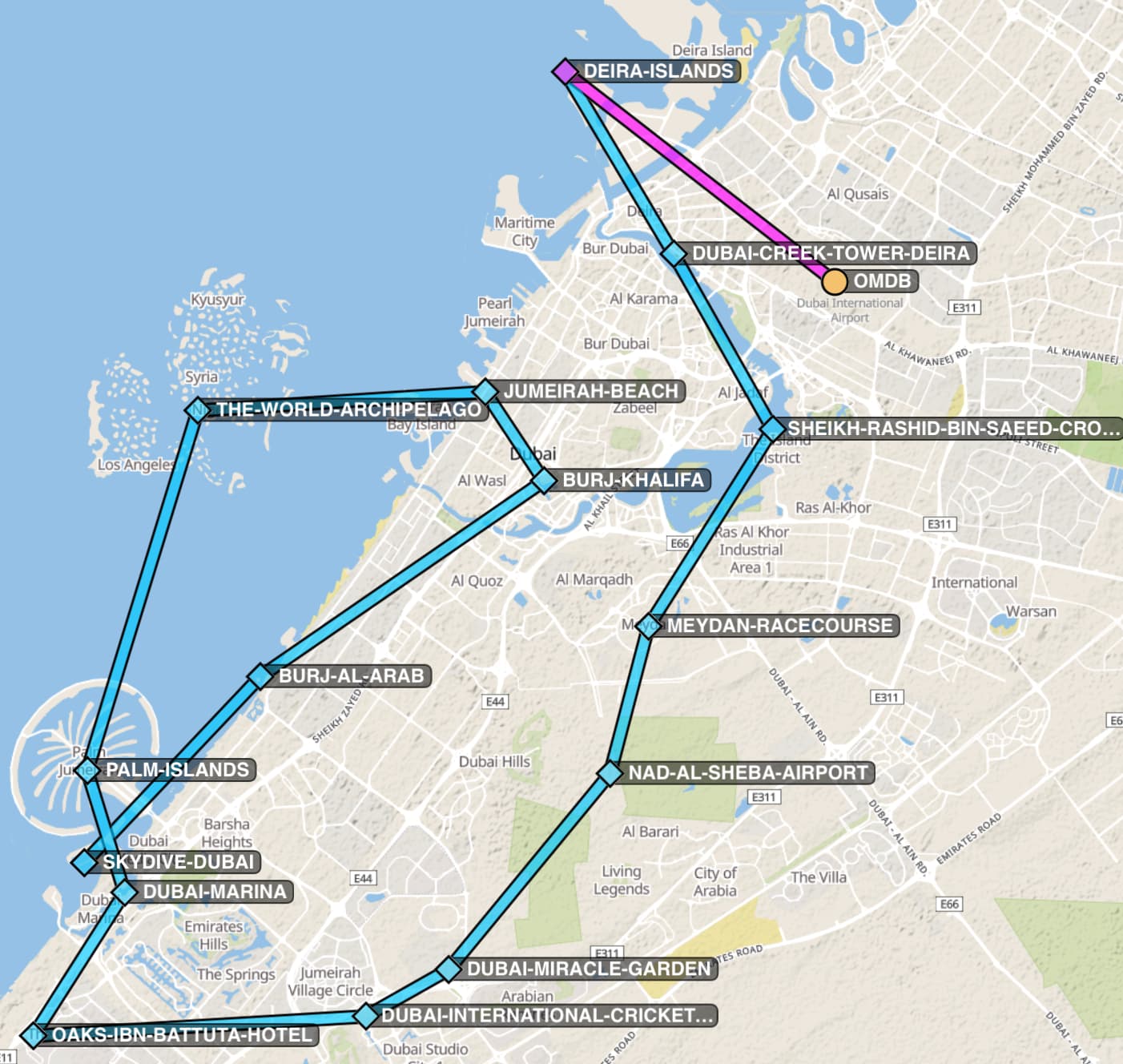
Flight Plan:
(They are identical, the second just has short waypoint names to work around this bug.)
- DubaiCreekAndPalmIslands.pln (4.3 KB)
or - DubaiCreekAndPalmIslands_VFRMapFriendly.pln (4.1 KB)
Airplane: Cessna 152 or similar (might be a fun flight for a helicopter if you’re feeling adventurous! I’ll be in the Cessna 152 Aerobat though ![]() )
)
Weather: High Level Clouds (or Live Weather, if it’s good for flying)
Liftoff Time: 6:35am (2:35 am UTC) for a sunrise flight
Rough flight path: OMDB->OMDU (called “Skydive Dubai” in the image), mostly at 1000 ft