Errors of AMBIENT WIND Y dependencies on the values of flight conditions and terrain settings in SU11

:wave: Thank you using the Bug section, using templates provided will greatly help the team reproducing the issue and ease the process of fixing it.

Are you using Developer Mode or made changes in it?

No

Have you disabled/removed all your mods and addons?

Yes

Brief description of the issue:

Errors of AMBIENT WIND Y dependencies on the values of flight conditions and terrain settings in SU11 are erroneous and significantly affect the flight in MSFS2020.

Provide Screenshot(s)/video(s) of the issue encountered:

Presented in the text

Provide coordinates (DevMode > Options > Display position)

Everywhere

Provide time & date of the observed Weather issue

At any time and date

Detailed steps to reproduce the issue encountered:

Described at the bottom of the text

PC specs and/or peripheral set up if relevant:

For any PC specification

Build Version # when you first started experiencing this issue:

Some problems were earlier and are present in SU11


:loudspeaker: For anyone who wants to contribute on this issue, Click on the button below to use this template:

Do you have the same issue if you follow the OP’s steps to reproduce it?

Provide extra information to complete the original description of the issue:

If relevant, provide additional screenshots/video:

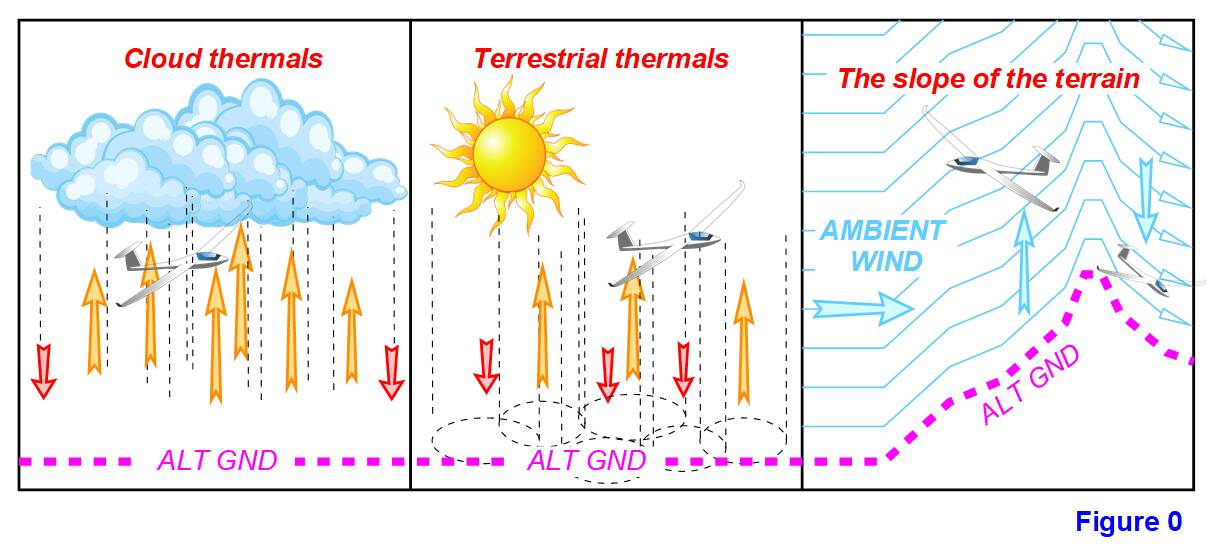
SimVar AMBIENT WIND Y is a derivative of simvar AMBIENT WIND VELOCITY and depends collectively on several variable weather settings and flight terrain. In MSFS2020, after SU11, there are three types of simvar AMBIENT WIND Y value formation, which are: Cloud thermals, Terrestrial thermals and Terrain Slope (see Figure 0.).

Cloud thermals form the values of simvar AMBIENT WIND Y in the presence of clouds of the lower layer such as Cumulus clouds (Cumulus, Cu) and Cumulonimbus (Cumulonimbus, Cb).
Terrestrial thermals form the values of simvar AMBIENT WIND Y in the presence of solar heating of the surface.
The slope of the terrain is formed by the values of simvar AMBIENT WIND Y in the presence of wind over inclined surfaces.

1. Cloud thermals

Error 1. AMBIENT WIND Y for cloud thermals depends on Cloud Density, but in SU11 this dependence is incorrect (see Figure 1.). The maximum value of AMBIENT WIND Y should be obtained already with normal Cloud Density equal to 1.

Error 2. AMBIENT WIND Y for cloud thermals depends on Cloud Layer Altitude Top-Bot (the thickness of the cloud layer), but in SU11 this dependence is incorrect (see Figure 2.). With the thickness of the cloud layer from 0 to 4000 ft, the value should increase sharply and proportionally to 80%, further increase in the thickness of the cloud layer the layer only slightly increases the value of simvar AMBIENT WIND Y.

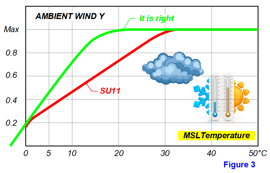
Error 3. AMBIENT WIND Y for cloud thermals depends on MSLTemperature, but in SU11 this dependence is incorrect (see Figure 3.). The maximum value should be reached at a temperature of about 10-15 ° C.

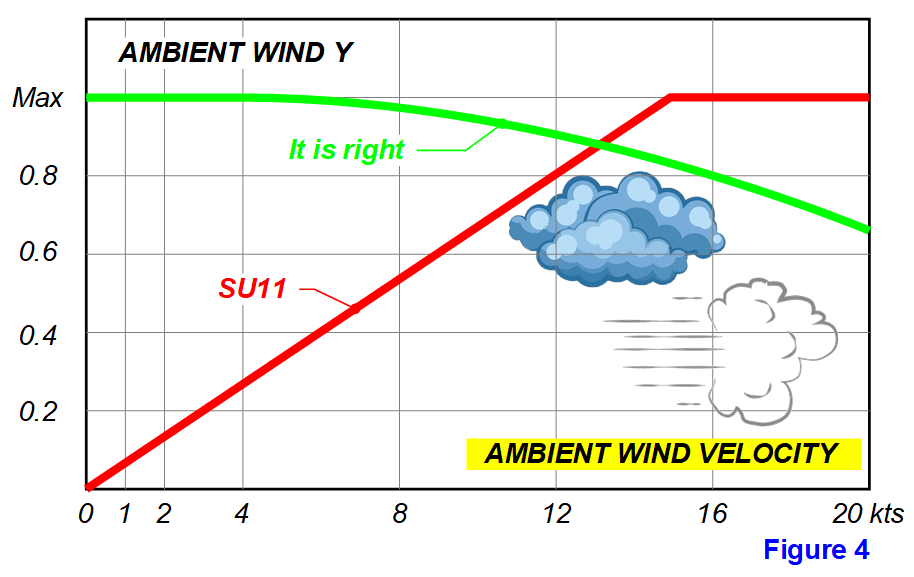
Error 4. AMBIENT WIND Y for cloud thermals depends on AMBIENT WIND VELOCITY, but in SU11 this dependence is very incorrect (see Figure 4.). In the absence of wind, the value should be maximum. When the wind increases more than 4 kts, the value decreases.

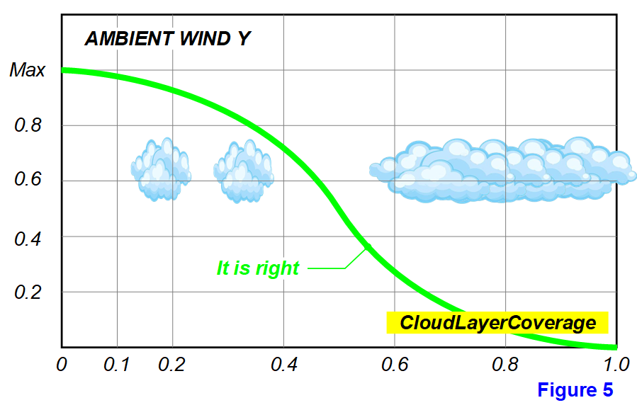
Error 5. In SU11, there is no dependence of AMBIENT WIND Y for cloud thermals on CloudLayerCoverage, but it should be (see Figure 5.). With a minimum percentage of cloud cover, each individual cloud has the maximum effect on AMBIENT WIND Y. With an increase in the percentage of clouds, the value decreases.

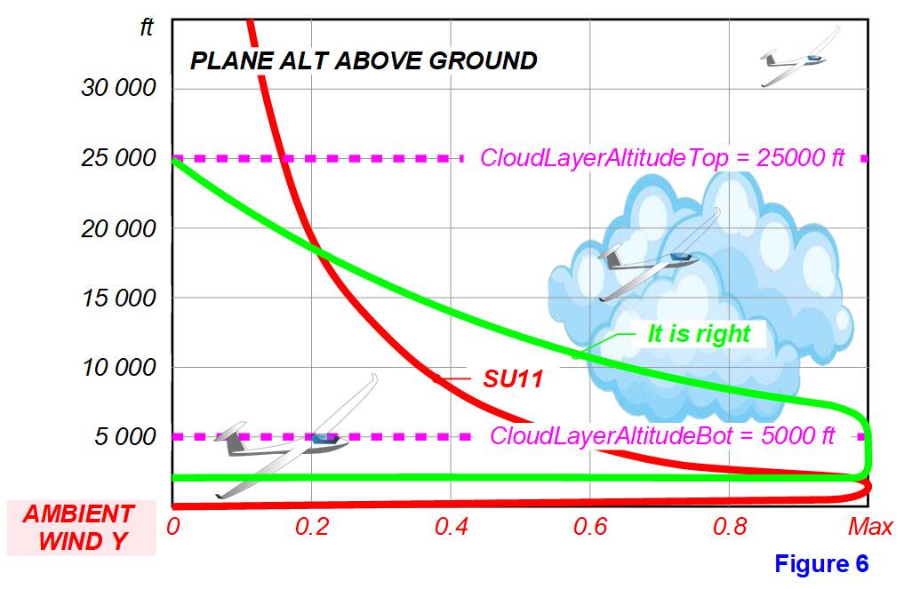
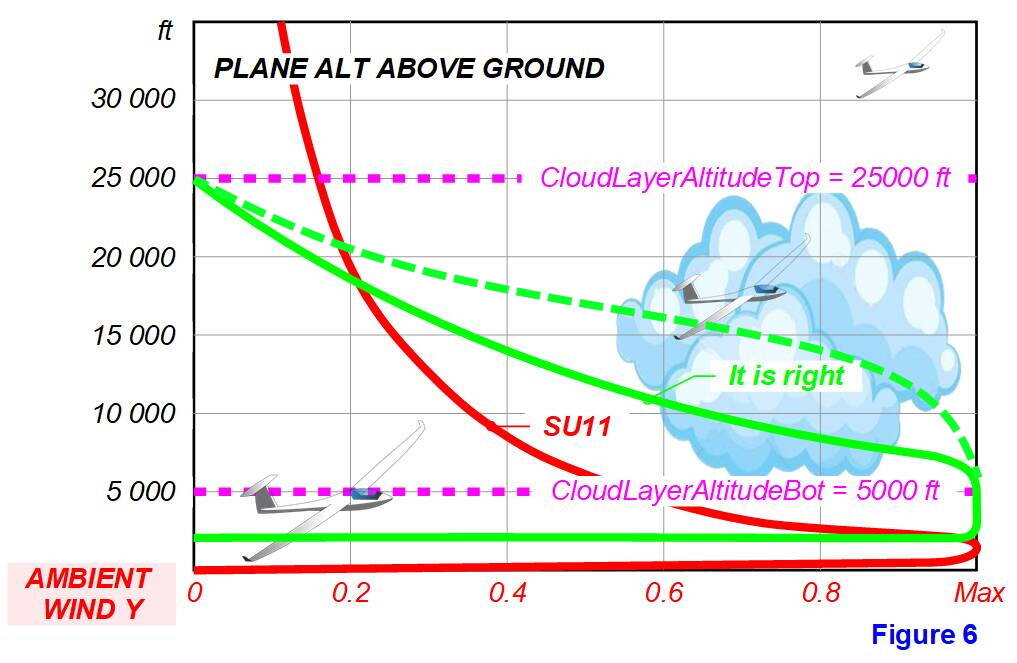
Error 6. The value of AMBIENT WIND VELOCITY in cloud thermals varies depending on PLANE ALT ABOVE GROUND (see Figure 6.). This value is 0 at the height of the surface. The value should appear only starting from 1/3 - 1/2 of the CloudLayerAltitudeBot height and almost immediately at the maximum value. Further, this value remains at the maximum up to the height of CloudLayerAltitudeBot. Above CloudLayerAltitudeBot, this value should be reset to the top of the cloud. There should be no cloud thermals above Cloud Layer Altitude Bot!

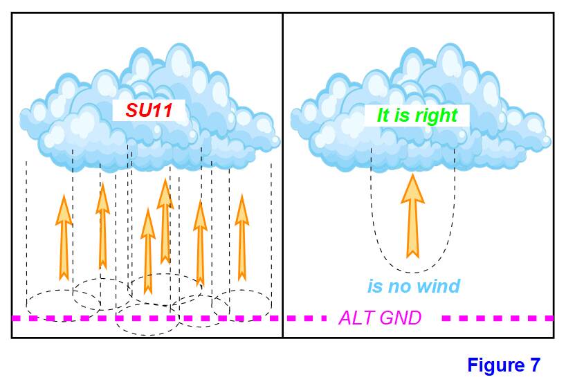
Error 7. Now in MSFS, large clouds are essentially a cluster of smaller clouds and each of these small clouds generates its own cloud thermal (see Figure 7.). It seems that there are several thermal cylinders under one large cloud, or there is one “wide” thermal under this cloud, in the body of which there are several pronounced areas with different speeds of vertical air flow. This shouldn’t be happening! The cylinder of the cloud thermal is always clearly formed and has a much smaller diameter than the size of the cloud itself.

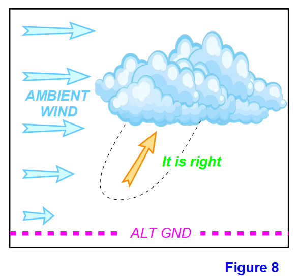
Error 8. In the presence of wind, clouds move with the wind along with the cloud thermals (see Figure 8.). But, at the same time, the cylinder of the cloud thermal must have a slope from the vertical in accordance with the wind speed. The lower area of the thermal is almost always “behind” the cloud. This needs to be implemented in MSFS.
8

Error 9. There is no turbulence inside the clouds in SU11! She has to be there! Its presence and activity can be associated with the thickness (height) of the cloud layer and its density.

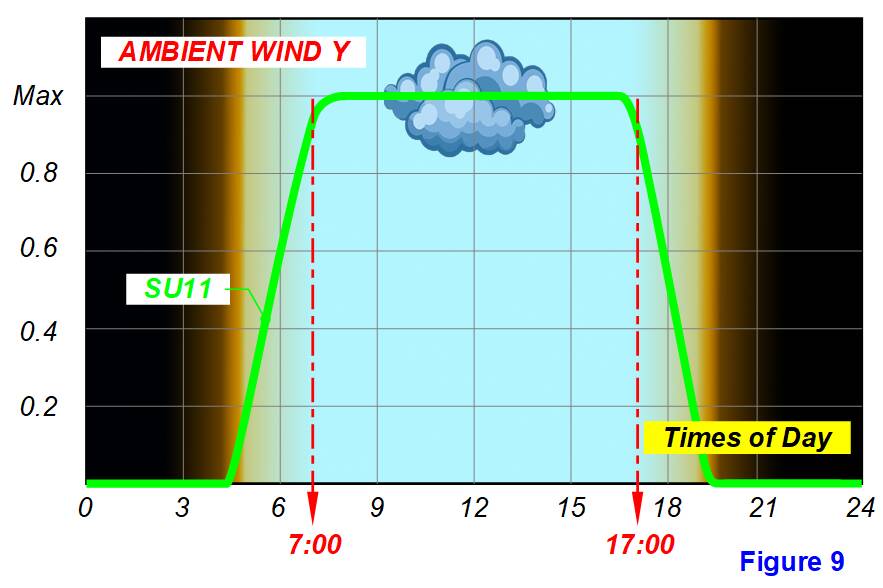
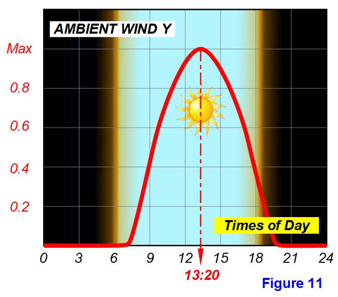
AMBIENT WIND Y for cloud thermals depends on the time of day. In SU11, this dependence is correct (see Figure 9.). AMBIENT WIND Y is absent at night, appears and gains a maximum during morning twilight, stays at a maximum all sunny day, decreases to a minimum during evening twilight and resets.

2. Earth thermals

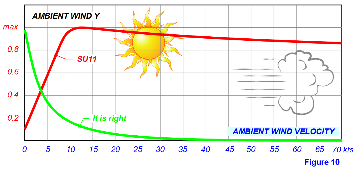
Error 10. AMBIENT WIND Y for terrestrial thermals depends on AMBIENT WIND VELOCITY, but in SU11 this dependence is very incorrect (see Figure 10.). The complete absence of wind should correspond to the maximum flow velocity and with increasing wind speed should progressively decrease the flow velocity. At a wind speed of more than 20 kts, the flow velocity is almost zero, heated air due to turbulence above the ground is mixed with cold air and does not rise above the heating site.

AMBIENT WIND Y for terrestrial thermals depends on the time of day. In SU11, this dependency is correct and it must be saved in the following SU (see Figure 11.).
11

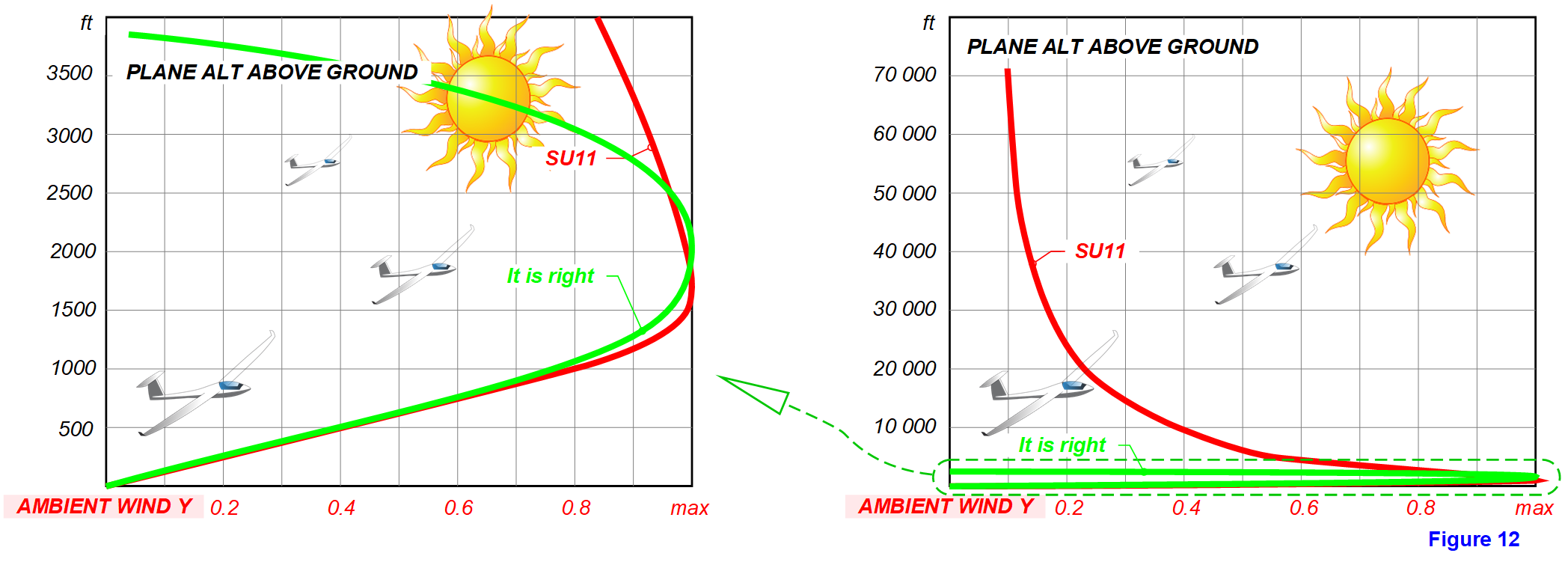
Error 11. AMBIENT WIND Y for terrestrial thermals correctly depends on PLANE ALT ABOVE GROUND to a height of approximately 800-1000 ft, then with increasing altitude it decreases. But, this is correct only up to a height of about 3000-4000 ft, after which it stops. Why does it continue to remain in force 10-20% at altitudes from 20,000 ft and in “space”?! (see Figure 12.). I understand that in the absence of wind (anticyclone), the heated air really warms up the entire height of the troposphere, but the speed of its rise is negligible. I propose to limit the presence of AMBIENT WIND Y for terrestrial thermals with a height of 4000 ft above the surface.

Error 12. AMBIENT WIND Y for terrestrial thermals depends on Cloud Layer Altitude Top-Bot (cloud layer thickness), but with CloudLayerCoverage=100% and Cloud Density=1, the entire surface is covered by cloud shadow and there should be no thermal activity (see Figure 13.).

Error 13. AMBIENT WIND Y for terrestrial thermals does NOT depend on the presence of snow. If there is snow on the surface, there should be no thermal activity.

Error 14. AMBIENT WIND Y for terrestrial thermals does NOT depend on precipitation (rain). If there is precipitation, there should be no thermal activity.

Error 15. AMBIENT WIND Y for terrestrial thermals depends on the type of surface (pond, sand, stone, land and their color, grass, shrubs, forest, etc.). But, an airplane (glider) determines the type of surface only under itself and cannot determine the type of surface in its environment. Therefore, flying over different types of surface, the value of AMBIENT WIND Y for terrestrial thermals is constantly and sharply changing, there is a continuous “turbulence”, sometimes very strong. To reduce “turbulence”, I suggest Applying smoothing of the flow rate of ground thermals.

3. The slope of the terrain

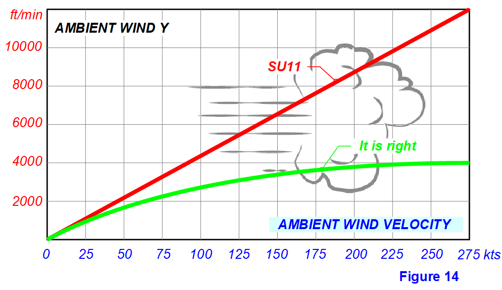
Error 16. AMBIENT WIND Y for terrain slope depends on AMBIENT WIND VELOCITY, but in SU11 this dependence is very incorrect (see Figure 14.). We cannot imagine an AMBIENT WIND Y value of more than 4000 ft/min (20 m/sec).

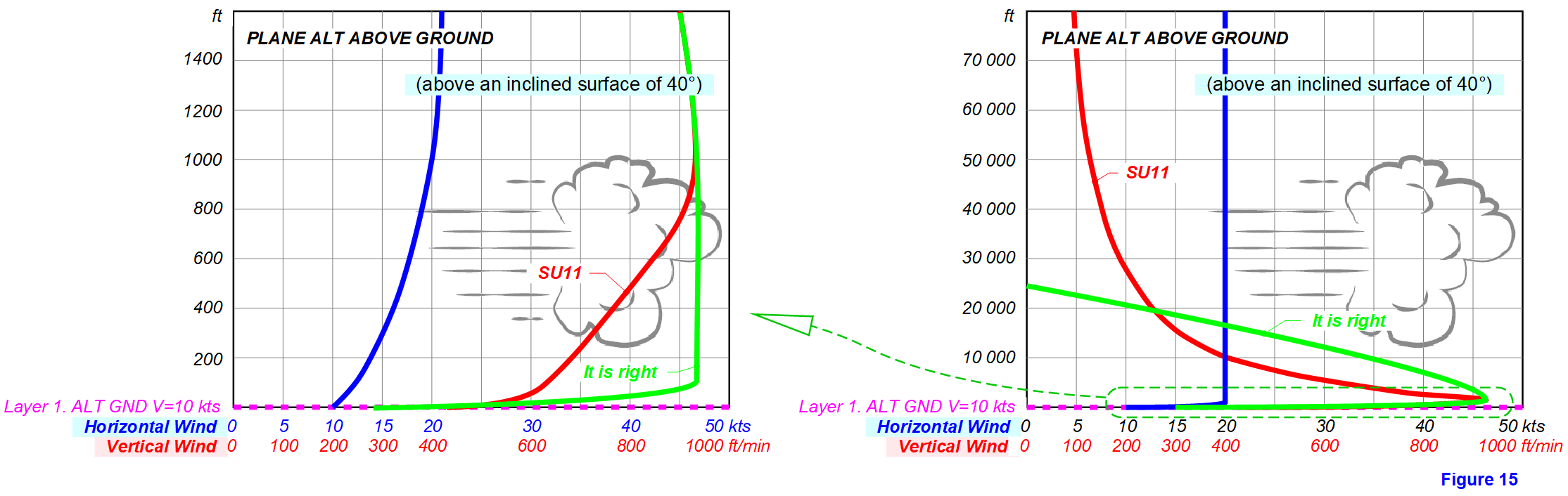
Error 17. AMBIENT WIND Y for the slope of the terrain depends on PLANE ALT ABOVE GROUND, but in SU11 this dependence is very wrong (see Figure 15.). The problem is that the glider (airplane) “sees” the surface only exclusively in the coordinates of its location and in no way “sees” the surrounding area. He cannot determine the height of the elevation of the slope, cannot distinguish the slope of a small embankment from the slope of high mountains. Therefore, the velocity of the vertical air flow over the elephant does not depend on the height of the slope elevation and can be the same when flying over the slope of the embankment and when flying in the mountains.

Error 18. The velocity of the vertical air flow over the elephant is incorrectly determined, depending on the altitude of the flight over this slope. Now, even with a wind speed of only 10kts, at an altitude above 40,000 ft, you can get a good flow rate. And at high wind speeds, you can easily climb into “space” even flying over a small embankment! I understand that this “trick” allows you to simulate turbulence at any altitude, but this is the wrong decision. Turbulence should be modeled by random variables of wind direction.

Error 19. At the very surface of the slope, the wind slows down, which is now 50%. At an altitude of 800-1000 ft, the wind speed is gaining full force. Accordingly, the velocity of the vertical air flow changes proportionally to the wind speed. I think that this does not quite correspond to reality, it is desirable to change the braking at the ground to 30% and set the full wind speed at an altitude of 100-150 ft.

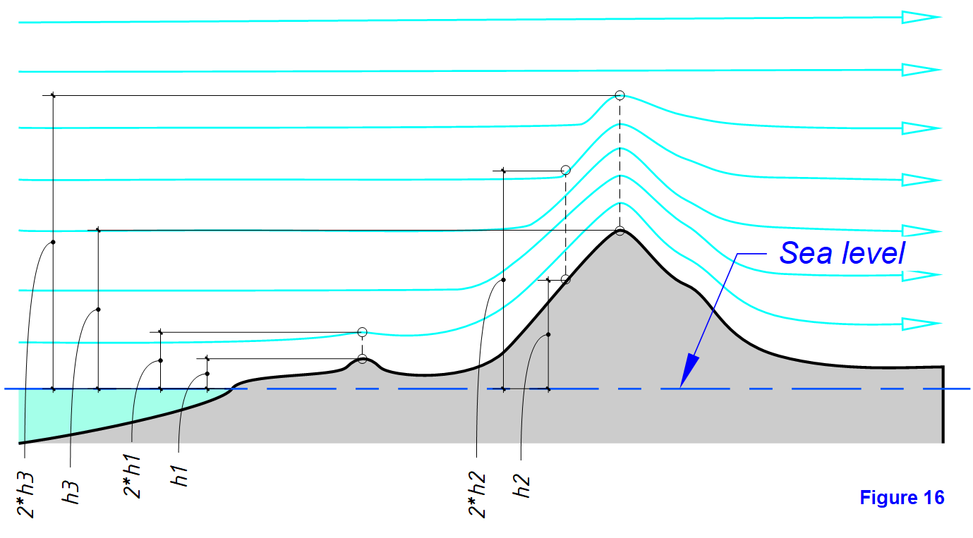
I suggest that developers limit the effect of the lifting layer over inclined surfaces to a height equal to two heights above sea level of the underlying surface. At the same time, the velocity of the vertical air flow (both ascending and descending) above the slope within the height of the layer fades from the maximum to the minimum at the top of the layer. Above the top of this layer there should be no vertical air movements associated with the slope of the earth’s surfaces (see Figure 16.).

AMBIENT WIND Y studies were conducted using the program Simvars.exe (see MSFS SDK\Samples\SimvarWatcher\bin\x64\Release)

When exploring AMBIENT WIND Y for terrain slope:

  1. The influence of cloud terms is reset to zero by the values of CloudLayerDensity and CloudLayerCoverage equal to zero.
  2. The influence of solar heating of the surface is reset by the choice of the place and day of the year for the flight and the minimum solar activity. For example, for the northern hemisphere of the earth, this is the day of December 22. The flight time can be dawn or sunset. Choose a place above the northern slope with a north wind.

In the study of AMBIENT WIND Y for cloud thermals:

  1. The influence of the wind over inclined surfaces is reset by the choice of the flight location over flat horizontal surfaces, for this flight over the sea or a large lake is ideal.
  2. The influence of solar heating of the surface is reset by the choice of the place and day of the year for the flight and the minimum solar activity.

In the study of AMBIENT WIND Y for terrestrial thermals:

  1. The influence of cloud terms is reset to zero by the values of CloudLayerDensity and CloudLayerCoverage equal to zero.
  2. The influence of the wind over inclined surfaces is reset by the choice of the flight location over flat horizontal surfaces, for this flight over plains without irregularities is ideal.
22 Likes

Wow! That’s a very thorough analysis of vertical wind in SU11. Thanks for providing this and comparing it to the real weather. This will surely be an unvaluable resource for the devs to improve the wind model.

4 Likes

Great analysis @ANRI8496

I’ve been flying gliders in the sim for nearly 1000 hours and i agree with all of the above.

The potential of MSFS is huge, but all these inaccuracies are making it very difficult for us glider pilots to enjoy thermal soaring.

3 Likes

These errors significantly affect not only gliders, but also all aircraft. Not only in weather presets, but also in real weather.

10 Likes

What this analysis is pointing out is probably what’s mostly preventing condor pilots to move to MSFS. Must have!

4 Likes

that is probably the best bug report i ever seen. and i do software engineering for living… upvoted :facepunch:

4 Likes

Almost all of the above dependencies existed before SU11. In principle, there is no need to “invent” something new, you just need to configure these dependencies correctly.

4 Likes

In one of the dev streams they said there will be a more advanced UI allowing for better tuning of weather presets (including thermals) in the future.

If we had full control over all these dependencies and variables that would be fantastic.
But i’m afraid we will get another over-simplified version of it.

And that would also not fix wrong values in live weather.

1 Like

+1 Excellent piece of analysis, surely must be valuable to Asobo.

I’d like to suggest a couple of refinements:

(Figure 6) - Lift between cloud layer bottom altitude & top altitude:
I agree this is correct in principle but would like to add that usable lift for a glider on a decent thermalling day may extend ~ two-thirds into the height of the cloud. I.e. when I’ve emerged from a cloud climb it’s possible to see the bulk of the cloud mass beneath me, for the cloud I climbed in and the surrounding clouds.

(Figure 7) The ‘slope’ of the thermal with the wind:
This might be just a clarification. IMHO this is a complicated because in a simulator it depends whether the thermal is described in the frame-of-reference of the cloud or the ground. Ultimately, the essential fact is if you’re, say, half way between the ground and cloudbase, then you can circle in the thermal up to cloudbase without requiring huge corrections due to the wind. This could be described as that part of the thermal being vertically under the cloud and drifting with the cloud OR as being sloped relative to the ground. To the second approximation, IF you have to correct your turn while circling in a thermal, then it seems you are more likely to need to do that INTO WIND than in another direction, but this is nothing like continually correcting into wind to compensate for the full wind drifting you out of the thermal. Possibly what you’re doing at that point is picking up a later bubble from the same (fixed) ground source. There is huge subtlety here - the actual upward trajectory of the thermal to the cloud drifting with the wind isn’t exactly known. A ‘snapshot’ that suggests the thermal is a straight diagonal line from the heat source on the ground to the base of cloud is probably not quite right as at normal cruising altitudes (e.g. half cloudbase to cloudbase) the thermal is more directly under the cloud than a diagonal line would suggest.

(Figure 10) “Earth thermal” vs wind:
I know it’s a bit strange talking about “earth thermals” and “cloud thermals” when in RL these are connected, but looking at Fig 10. I’d like to suggest that certainly up to at least 10 knots, thermalling at any height in RL is pretty much unaffected, i.e. if the airmass is going to give you 5 knot climbs, it doesn’t seem to matter if it’s zero wind or 10 knots wind, you can still climb at 5 knots assuming you’ve found the thermal.

Please note my intention for these comments is INCREMENTAL enhancements to the excellent analysis above, i.e. refinements of a couple of the concepts described. IMHO in terms of incremental improvement to the current MSFS implementation of thermals the analysis provided by ANRI is excellent.

B21

5 Likes

If these dependencies are correctly configured, they will work correctly both in weather presets and in real weather.
Now in SU11, the real weather works just as incorrectly as in presets. The reasons are the same.
The number of errors mentioned above tells us that it is impossible to transfer them all to the user interface settings. They need to be corrected and adjusted first.

2 Likes

If we are talking about the USEFUL lifting force, then the graph shows that at an altitude of two-thirds of the height of the cloud, the value will be approximately 20% of the maximum and this is quite consistent with the USEFUL.

In the simulator, the thermal is rigidly tied to the coordinates of the cloud, and the cloud is tied to the current coordinates of the earth. Also, the values of AMBIENT WIND VELOCITY and AMBIENT WIND Y are known. There are no problems to determine the slope of the thermal, its location and the location of the glider at a specific point of the thermal.

This is a big misconception. In the real world, they can only be connected in very rare cases., with a strong current and very weak wind. As a rule, the wind tears off the ascending bubble of warm air before its upper edge reaches the height of condensation and forms a cloud.
We will be able to observe such rare cases even in the simulator when the cloud thermal will “fly” over the terrestrial thermal.
The most typical examples of linking clouds and terrestrial thermals may be clouds over sunny mountain slopes. At the same time, wave clouds are not such.

2 Likes

I particularly enjoy thermalling in clouds and would never stay in a 5-knot thermal until it becomes 1 knot. Your Figure 6 green line is great, but here’s a suggestion (the dashed line) of a slight improvement based on what I’ve seen climbing in clouds:

Note this lift only applies IF you’re still in the thermal. Obviously if you wander at random inside the cloud you’ll get weaker lift or none, so that is challenged in the current sim with the very broad areas of lift. But with sensibly shaped clouds (i.e. Cu’s) it is normal to be able to climb up inside the cloud and emerge with a towering landscape beneath you, and you’re certainly not waiting for the lift to weaken to 20%.

Thermalling in clouds is a joy, both when you’re in the quiet in the gray, and when you emerge to see the magnificent puffy landscape around you. Unfortunately it’s terrifying the first ten times you do it.

B21

4 Likes

Sigh. What I mean is it is the same mass of air… there are not two different independent thermals. I am sure you agree with me.

2 Likes

Yes exactly the same airmass.
I hope this is just an incorrect translation of word “connect” that is the issue here, as this casue and effect relation that airmass warmed by ground, rising to the condensation height is the direct cause of the Cu cloud (and also the strongest factor of lift under typical Cu cloud, and not some “cloud thermal”) is fundamental to the whole problem of current thermal implementation - where “ground” thermals are not related to clouds, and separate to “cloud thermals” - while in RL this is exactly the same air that simply rised to the condensation height.
ANRI you already posted an illustration on discord that exactly shows this:
obraz
Air from section “a” rising to the condensation height showed in section “b” forms a cloud, when heat source stops generating rising air in section b and c, there is still some time till the rest of the rising from ground source air arrives to condensation height, then there is still some lift generated by latent heat of condensation so the cloud still lives for some time but the dissipation starts (section “d”).

1 Like

Does the “Y” mean the vertical direction? If so, then this is yet another indication that MS hasn’t had a meteorologist anywhere near the FS development. In meteorology, atmospheric science in general, the vertical direction in all text books, articles, etc., is always “Z”. Nobody from the field would ever use “Y” for vertical.

LOL I’d cut MS/Asobo some slack there… the x/y/z orientation in Microsoft Flight Simulator dates back at least 30 years.

2 Likes

You are right, it’s rather 3D modelling type of Euler system. But changing coordinates system will bring so much headache for everyone, let’s not add another bullet to this huge list :grin:

2 Likes

Amazing , Give that man a job .
Not sure MS/Asobo realized what the introduction of gliders ment ,
And they thought helicopters were complex .

Let us fly in real air please . The gliding community will help fix the weather for everyone .

Super detailed Anri , Thanks for your time.

I think a glider slider is the only option , the general users will not see this as real because its never been in sim before .
I’m living in hope the can implement , and the weather data used for modeling is sufficient .
Complex hey , you actually realize this after you go solo , " I can do a circuit, but i know NOTHING"

1 Like

This figure shows the individual phases of cloud development. Consider these not only as phases of cloud development, but also as phases of time and local locations.
In phase (b), a cloud is formed from air heated above the surface in zone (a), but it has already shifted away from zone (a) and has no connection with the surface.
Please note, at the same time, the heating of the terrain continues over place (a) and a new cycle begins for the next cloud.

3 Likes