So my main interest at the moment is finding interesting places to fly around and sight see.
The world map satellite layer is so low-res it’s practically useless.
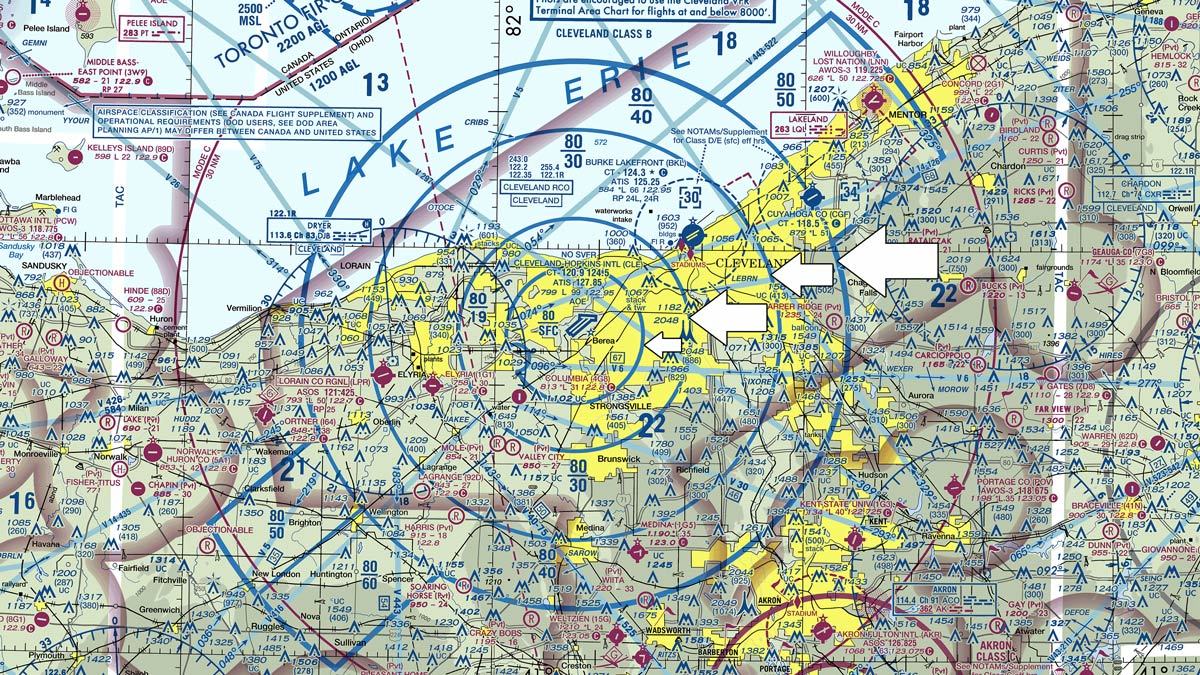
What I was expecting was a flight chart layer. Something like this:
Thought that would be standard, but maybe I’m expecting too much and it would add $$$ to the cost of the product. Hopefully there may be mods for this in future.
4 Likes
I wish we had something like SkyVector for our flight planning utility. Or maybe just a way to load it into the map window.
1 Like
I made a Flight Planner/VFR tool that lets you view a tracking map and the SkyVector chart too. It is available, but still a work in progress.
Thanks I’ll check it out.
Well, there’s LittleNavMap that works. But I just use SkyVector on another screen and a paper notebook that I put my radio and nav info on.
2 Likes
Yes I also would like a more complete map to view during the flight, as a minimimum the names of cities…
Ciao
Agreed, and I would like city and airport names to be overlayed in the Manual Cache map as well.
I would love to see basically skyvector in Flightsim. That way it also would easier to do flight planning
While there are some good workarounds (SkyVector, LittleNavMap), I do believe that a SIM so expert at delivering VFR scenery should way better assist its users in VFR flight planning.
Some issues I have:
- SkyVector only has proper VFR charts for the US but nothing but airport locations and terrain for the rest of the world. That is the main reason I almost exclusively fly within the US. The in-game flight planner might use Bing maps for picking the landmarks and routings, that would suffice and be way cheaper than acquiring world-wide VFR charts for in-game use.
The options “Direct GPS” and “VOR to VOR” just don’t suffice.
-NAV log fault: When flying a self-made plan, the NAV log has a column “Heading” which is incorrect. It is in fact a column “course” that does not take into account the prevailing winds. I would expect the SIM to create upon starting a flight a NAV log using the current winds the SIM uses and calculate the required headings from the individual leg courses and to display both. For that, either the winds at a fixed intermediate altitude might be used (5000ft for example) or at any altitude specified in the flight planning stage. So far I have found only two workarounds for that: either using a preset weather with no wind whatsoever (boooring) or using a glass-cockpit (GPS) aircraft that displays the track I fly (feels like cheating).
Since I do have my doubts about how close the winds aloft from the weather model match the different official forecasts, that is something I’d prefer the sim do for me.
I would however not expect the SIM to do recalculations enroute when winds change.
What are your thoughts about this topic?
Greetings!
1 Like