Hello:
I am having trouble with inputting my flight plan into the G1000. Here’s what happens: I create a flight plan in Little NavMap; I can either export it and load it into MSFS or manually enter it - the result is the same: When I attempt to enter the altitudes for the waypoints into the flight plan, it crosses all of them out, regardless of what I put in for the altitude - these altitudes I obtained from the LNM flight plan. It is very frustrating to take the time to create a flight plan (which at least I think is correct) only to have the G1000 reject it. It isn’t because the aircraft cannot get to these altitudes (172) - the G1000 just doesn’t seem to like my altitudes.
Any help would be most appreciated.
A screenshot of the flight plan screen in the G1000 would be very helpful.
Usually, I see crossed out altitudes during descent, and it means the aircraft is unable to reach that altitude using allowed speeds or 3 degree descent path angles.
I don’t generally populate all of the waypoints in a plan, I only let the ones part of an approach procedure or STAR automatically populate. Once I reach my cruise altitude it will compute the interim altitudes based on the future altitude constraints.
Hello, BC:
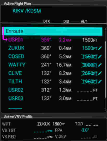
You can see between ZUKUK and COSED I put only 50’ difference and it didn’t like it. So, I’m confused.
Are you still on the ground?
Try this, don’t enter any altitudes. Climb to your cruise altitude. What does the flight plan look like then?
There’s no reason to enter climb altitudes, the G1000 can only provide LNAV and Descent VNAV.There is no climb VNAV - that’s on you as the pilot to set a vertical speed or rate to get to cruise. Most plans will provide a TOC (Top Of Climb) where your reach your cruising altitude which is what you hold for most of the flight, then a corresponding TOD (Top Of Descent) where you begin the let-down for arrival at the destination.
2 Likes
I will answer these questions tomorrow (Saturday). Thanks for replying.
Maybe MSFS Garmin doesn’t understand the difference of 50 feet? Try setting an altitude difference of 500 feet between navigation point. Maybe it will help.
This topic was automatically closed 365 days after the last reply. New replies are no longer allowed.