Version 0.6;
Using data from https://www.lvnl.nl/eaip/2019-08-01-AIRAC/html/eAIP/EH-AD-2.EHEH-en-GB.html;
- Calculated the midpoint of the runway: 51.450129 5.374512 for exact documented positioning
- Added ILS LOC frequencies and locations as documented.
– ILS LOC 03: FREQ: 109.750, ID: EHZ
– ILS LOC 21: FREQ: 109.750, ID: EHO
– Have not tried to land with ILS yet, never been able to complete an IFR route in MSFS yet. - Set Tower, Approach, and Ground frequencies so there is some communication with ATC.
– trying to figure out taxi routing and routing to parking, making progress with that.
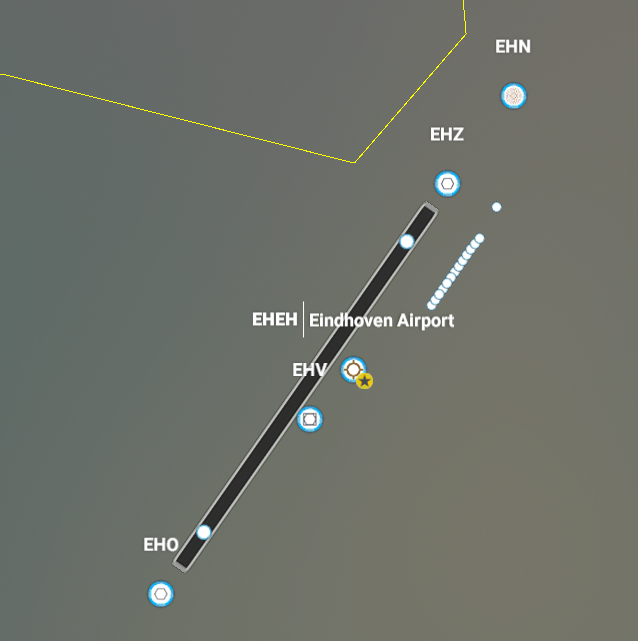
TACAN ID: EHV Is already present in-game on the correct location, will not adjust/override this.
Version 0.6 Aerial;
I have also a test version of 0.6 with Google Aerial images to unblur the area. Keep in mind that this is a quick test/preview as I have not done anything to the image sources such as clean up. What also might be noticeable is that the runway is slightly off than what is documented/calculated so I am not sure if I want to shift the runway to match the aerial images. Will work on this version as well to clean up and make sure to cover all the censored parts and that it connects nicely with the original bing imagery, like fields not cut in half due to different seasons the imagery was taken.
Before I focus on either updating the visuals around the taxiways/runways -like the aerial imagery shows like by making use of multiple layers- or by cleaning up the Google aerial images, I will focus on taxiway navigation/routing and parking first. Would like someone to test the ILS LOC approach, there might not be a glide scope available.