I have noticed that recently the vnav no longer works on G1000 on RNP approaches. Vertical glideslope is visible and the G1000 does calculate VNAV profile however the autopilot does not capture nor does it follow the profile. VNAV is armed however at decent point - it just disappears. I tried in several different aircraft - DA62, C208, C172 basically all of the airplanes that uses working tile G1000 nxi. It was working before and it was pleasure to fly RNP approaches. But with continuous recent updates - I think is broken.
Anyone else having similar issues?
What approaches and airports can other users try to repro?
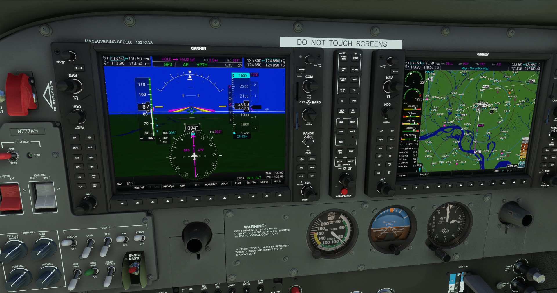
Just 20 mins ago I was trying the RNAV LPV approach 09 into Memphis (KMEM) in C208. On the approach I descended via V/S to 1700ft to FALIX (was levelled at 1700 5NM before FALIX) from which point VNAV was supposed to takeover 3.0 degree decent. however it didn’t.
So I tried RNAV 09 via BUDEE.
Long story short, VNAV works. I have a whole bunch of screenshots, but here’s the critical ones.
I started in the air to save time - set Nav Log Altitude to spawn me at 3500’ south of KMEM.
NOTE: Once airborne and stabilitzed, I immediately set the ALT Preselect to 1600, 100’ below my lowest authorized clearance on the approach - it’s an old habit from the days when VNAV wasn’t implemented in G1000.
Here I’ve already passed BUDEE headed toward FALIX. You can see VNAV is driving me to the FAF, and the GP marker is alive and moving down.
You can see the TOD marker in the MFD to descend me from 2000’ down to 1700’ - hasn’t activated because I’m not within 30 seconds travel time to it yet. GP Marker has ghosted - that’s expected. It’ll come back.
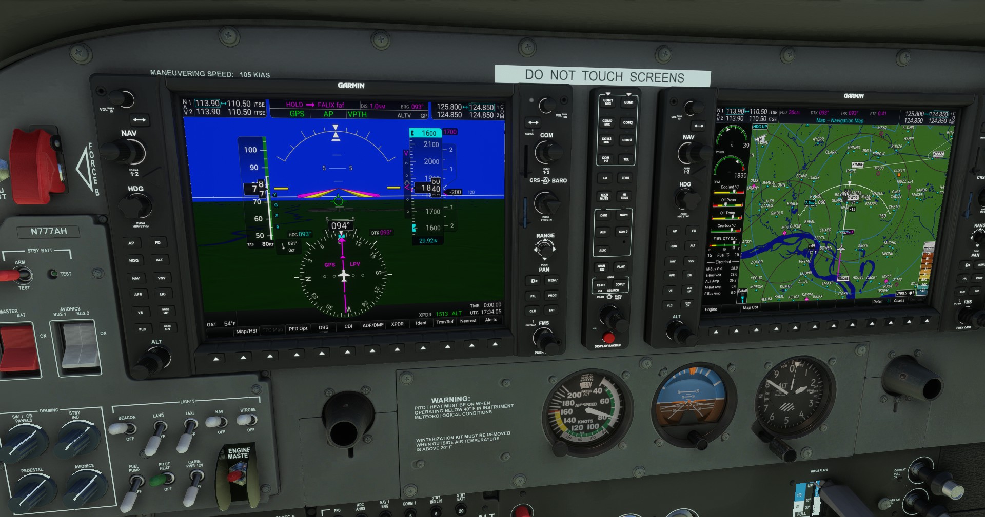
Just passed the TOD marker to bring me down to the FAF, VNAV is active, you can see VPATH blinking in the PFD Annunciator. Note GP marker has become magenta again.
GP Capture, even before I crossed the FAF. That’s nominal, it can happen on many approaches.
1 Like
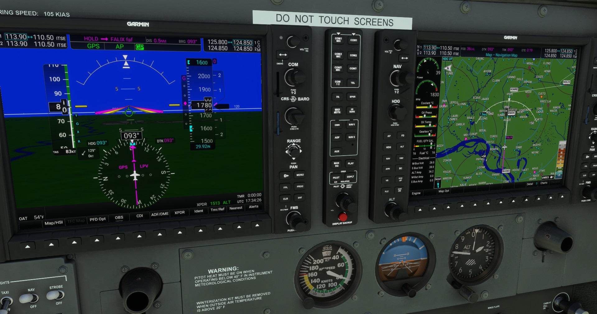
Generally speaking it’s not VNAV that brings you down from the FAF to the runway, it’s actually the Approach Mode. Note that in my top three screenshots above - you can see the White GP annunciator - meaning it’s armed waiting for input from the FMS to activate. I arm APR mode once I passed the last waypoint before the FAF - in this case, once I’m past BUDEE. Approach will capture the Glide Path (RNAV) or Glide Slope (ILS) in a fully coupled Approach mode (Autopilot).
VNAV - in conjunction with Autopilot, brings you down automatically from whatever altitude you happen to be to the first altitude fix in the Approach. It also remains the Vertical Navigation Mode up until the FAF.
In my case, I was on Autopilot when I spawned south of KMEM at 3500’ as I mentioned. I immediately turned the Altitude Preselector to 1600’ and pressed VNAV on the Garmin console. That illuminates a VPATH white annunciator on the PFD. What also happens is the Garmin immediately calculates where on my current flight plan should the plane begin descending to meet the 2000’ altitude EXACTLY at BUDEE. Where that point is, it will place a TOD (Top of Descent) marker on the leg where I must begin my descent.
About a minute before that TOD, a Magenta 2000’ will appear above the altitude tape, confirming that the plane will begin descending to 2000’ as the first step in the approach. 30 seconds before TOD flyover, VPATH will begin flashing to indicate it’s arming and to prompt the pilot to adjust power so they can maintain a safe forward speed during the descent. The descent stops where the MFD says BOD (Bottom of Descent).
It will repeat this process again on the BUDEE - FALIX leg. During that leg, you should arm APR mode by pressing the APR button on the Garmin console.
I think that last part may be why it didn’t bring you down - assuming you were on Autopilot.
3 Likes
Thanks for the screenshots. Wich plane is that?
Cessna JT-A - a Turbo-diesel version of the G1000 Skyhawk. It’s mod from MrTommyMxr and DanielLOWG.
1 Like
Okay thanks I will try this again and yes for earlier I was on autopilot.
Just FYI, I did the same approach with the stock 172/Garmin model and it worked fine.
Regards
1 Like
Is there a way to do a visual approach using the APR button and will it follow the GP ?
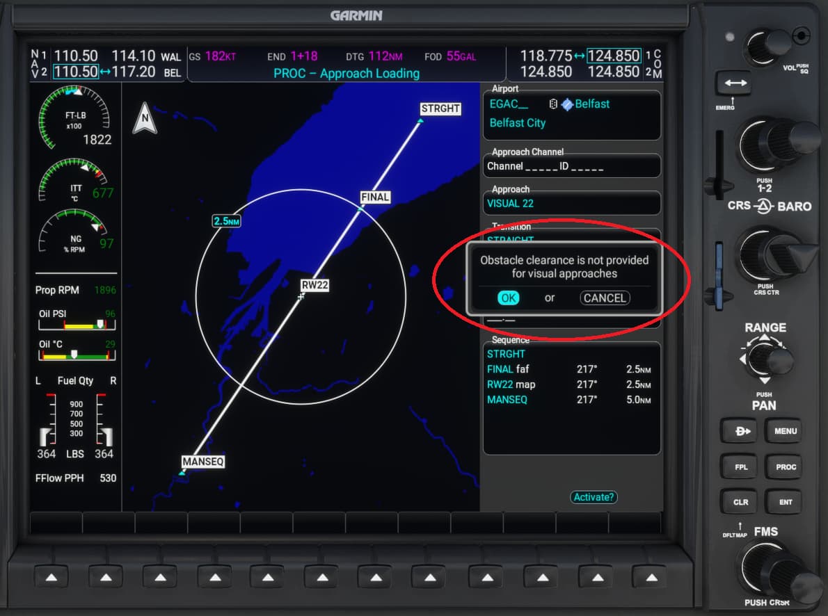
Yes - you load a Visual Approach to the runway (it should be available for all airports known inside the Garmin) and if you want a fully coupled approach (i.e., hands off) - select STRAIGHT, not VECTORS.
That will set you up on a 3 NM final. BEFORE you reach the waypoint that’s marked FINAL, note the altitude you need to be at when crossing FINAL - use the Altitude Pre-Selector and set that height then press VNAV. Assuming you’re not too high and not too close, the plane will turn towards STRAIGHT and establish a TOD to bring you to FINAL’s height fix.
Press APR before FINAL and you will capture a virtual Glide Path just like a defined RNAV approach and it will bring you down. Adjust power accordingly throughout the descent.
Note the big popup warning when loading the approach - Visual Approaches do not take into account any vertical obstacles / hazards on the approach. It builds a 3 degree GP and puts you on it. Any vertical obstacles are the pilot’s responsibility.
thank you very much i will give this a try
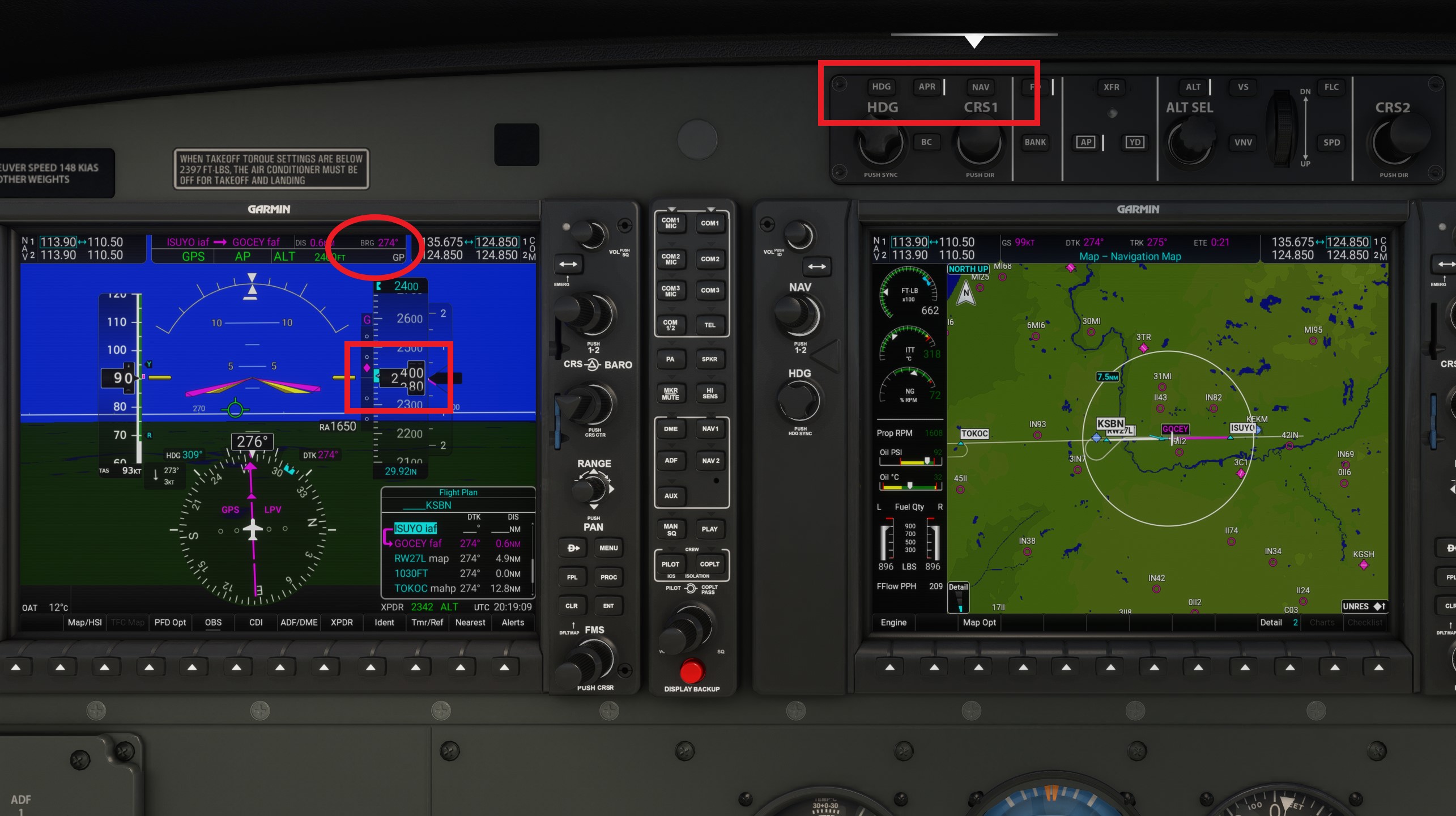
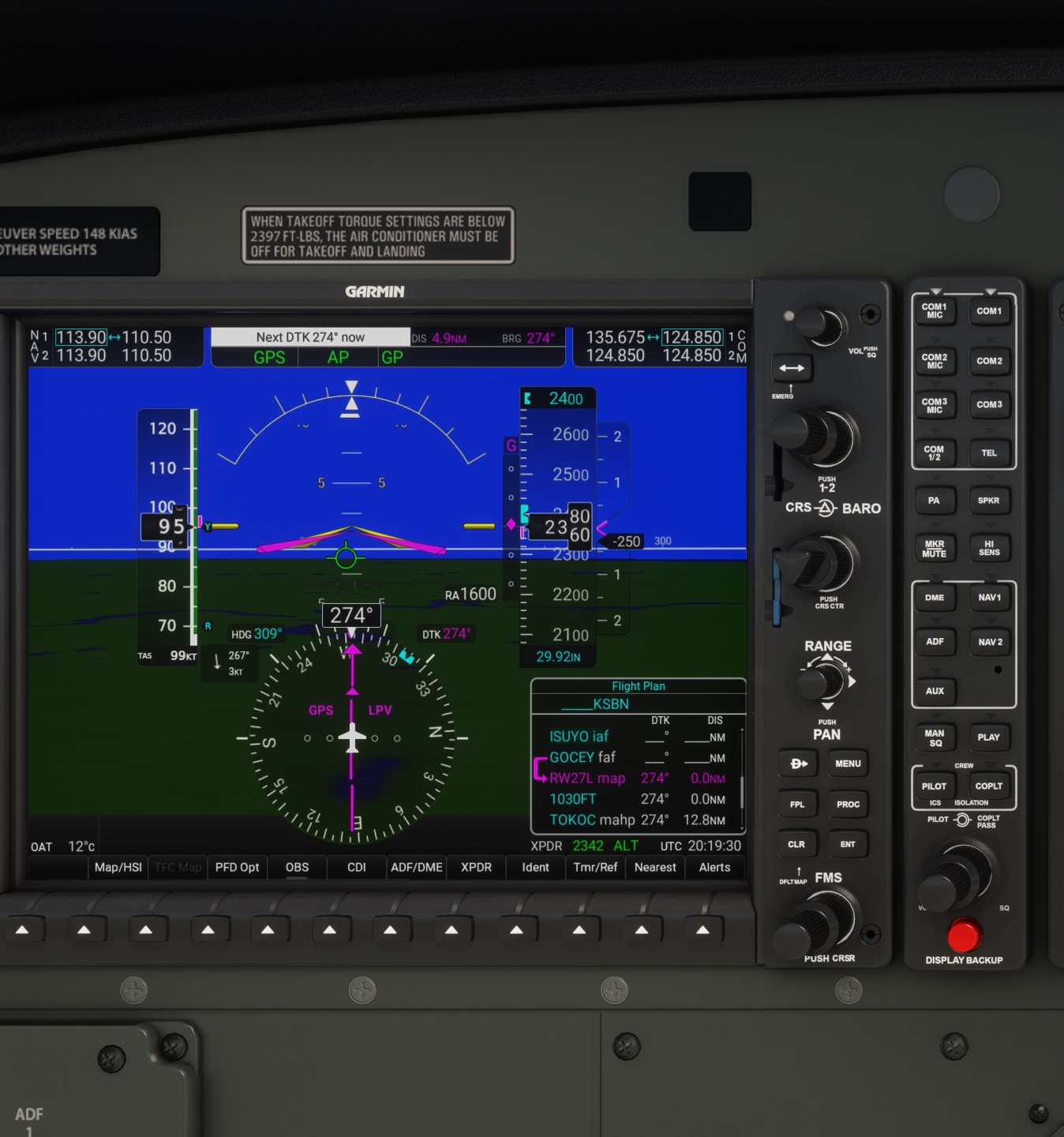
Okay So I reattempted another approach last night in C208 default one with G1000nxi. This time I was flying the RNAV GPS (LPV) RWY 27L into South Bend KSBN. I was cruising at 9000ft initially on track to GSH to then pick up the RNP approach. VNAV initially worked in getting me down to 2400ft before ISUYO which is the IAF. Then it maintains 2400ft until the final approach fix GOCEY. Here my 3.0 degree decent glideslope comes alive and on passing GOCEY - VNAV disappears again. I have already preselected 1100ft on Altitude select window to initiate decent after GOCEY with VNAV armed. But it doesn’t and reselecting VNAV does not do anything. The only other option then I get left is to use V/S to get back on profile. As autopilot continues to hold 2400ft past final approach fix.
Did you click on APR at the appropriate time as @CasualClick stated?
2 Likes
Let’s try a couple screenshots to emphasize what @CasualClick and @SlabsFly are saying.
The first shot shows I’m inside the IAP. I normally and press the APR button (inside the red rectangle) as soon as the “GP” red diamond becomes active (starts moving down the scale) (inside the red square on the screenshot). This will arm the glide path so the Garmin will follow the GP once it moves to the middle of the scale. The system in general will not capture the GP once the GP Diamond is slightly below the midpoint, so make sure you’ve hit the APR before it gets to the midpoint. You can basically hit the APR button anywhere inside the IAP since all it will do is arm the system, not make it change what you’re currently doing.
In the second screenshot, notice the GP indicator has turned green, meaning it’s now active and the Garmin will follow the glide path downward. In the screenshot, it’s just started to descend. At this point you’ve got a valid RNAV approach working, and you can follow it down to the minimum descent altitude (if you’ve got the chart for the airport, it will show what that altitude is). Note that I don’t use VNAV after I’ve hit the IAP for this approach. There’s more to an actual approach, but following the steps they’ve identified will get you on a valid RNAV approach/descent in the sim).
Regards
1 Like
I now realise where I went wrong - I didn’t arm approach mode. I was under the assumption that VNAV would intercept and follow the vertical profile all way down to MDA. I will try this again.
1 Like
I’ve been having some fun with VNAV in PNG and it appears that it is either trying to kill me or just scare me to death.
For example, I flew from AYMH to AYGA and had activated the Straight approach to runway 17R. On that approach Final has a target altitude of around 6,100ft and VNAV brings me down pretty much on target from around 12,000ft. However, the last turn into final takes you over some ridges, or at least it’s suppose to take you over the ridges, yet at the very least, it does not appear to have added a buffer for the height of the trees that grow on said ridges and some manual input is necessary to avoid clipping them.
I might be misunderstanding the uses of VNAV and it might just be a bit of an assistant, but I’d think that AP shouldn’t really be trying to crash you into the ground or get so close that you think you might. 
If it was a Visual Approach procedure, the big “No Obstacle Guidance” pop-up that requires you to click through is why.
A Visual Approach will drop you off at the 3NM final with a 3 degree GPA. It’s not going to calculate for any obstacles that impact the descent. That’s all Pilot Responsibility.
2 Likes
It was indeed a visual approach procedure.
I don’t recall having to click through any guidance, but that could be an “autopilot failing” on my part. 
I’ll watch for that next time, as it will be a regular route for me and my Kodiak.
No damage done, the trees and my impending collision with them was fairly obvious and i apparently made the right choice to interrupt the descent.
If you try to activate the visual, you will see this:
1 Like