Very cool to see that we may have figured it out. I really appreciate your help. Thank you for taking the time to fool around with it also.
No prob! When you load it from SimBrief, does it start with the plan loaded, or do you select and load it from the Garmin menu after startup?
I’ll have to try one on Simbrief and see what it does. I do not use it much. I mostly use the Navigraph route maker
The problem with this is that you get this information very late in the flight, extremely close to approach. I find it a bit too short time to properly plan your approach and landing. If ATIS is available thats usually sufficient, but the ATC info comes too late. A bit off topic, but do you really get the approach information that late irl?
Absolutely. And I’ll speak to US expectations only - I’m not sure about rest-of-world.
An approach is never part of the filed flight plan or clearance. You might be able to infer which approach you will be using if you have ADS-B/FIS-B data that allows you to observe the METAR and/or traffic flow from a ways out.
Further, it’s hard to know exactly which approach or arrival transition you’ll be given until it’s time to descend. You might be given “descend via” an RNAV STAR that connects seamlessly to the IAF of an approach, you might be told to fly direct to a feeder fix or IAF, or you might get vectored onto final. If conditions are VMC, you might not even get a specific instrument approach, but are instead cleared to fly a visual approach. This will also depend on equipment in your aircraft, op specs for different airlines (some aren’t allowed to do visuals), etc.
Now, if ATC is not super busy, you can request an approach with center before you descend, which is usually met with “request on file” or “I’ll forward your request to the next facility,” or if they have time to coordinate, maybe “expect xxx.”
In the absence of that, when you’re 100-ish miles out and at an altitude where you can pick up the ATIS (provided it’s not stale and about to change), that will give you an idea of which approach to expect and then about 50-60 miles out, ATC will give you the approach to expect or just clear you for it. If you listen to what other airplanes are being given, it might inform you. if it’s available, ILS is usually preferred, then RNAV, then others. If multiple runways are in use, it’s really up in the air (pun intended) until you’re called. Again, equipment and/or op specs may come into play.
Nonetheless, a huge of being proficient to fly IFR is being adaptable to whichever approach or other instructions you’re given. Once you are informed of the approach, you tune/enter/activate it, do the approach briefing, and whatever checklists remain.
I should add that interpreting weather forecasts before you even get to the plane can inform you of which runways might be in use at your ETA. If a weather/frontal system is sweeping through the arrival airport while you’re in the air, it could very well change which arrivals and approaches are in use when you get there.
If that happens while you’re in cruise, you might get an amended clearance to use a different STAR (some are only designed for certain runways), which will tell you a lot. Keep in mind that many aircraft can’t fly certain (or any) STARs, so it’s often straight from enroute to approach.
Lastly, you won’t always get what you request. If it’s busy and everybody is using the ILS, and you want the RNAV, you probably won’t get it.
That’s many of the reasons we don’t plan a specific approach while we’re still on the ground (unless the flight is a very short hop).
You’re supposed to follow an independent descent schedule based upon your calculated ToD while remaining on your flight plan laterally. ATC doesn’t do this for you, sim or IRL.
By referring to a vertical ascent / descent profile (Little Nav Map has a really detailed one, the sim’s Nav Log has a very bare bones one), you can derive where you should be altitude wise by waypoint following ToD passage. You make request descents to ATC and come down from cruise altitude.
Ideally, that descent puts you within a couple thousand feet of any IAF altitude fix at your destination. At which point, ATC synchs sufficiently to prompt you for the Approach and talks you down to the IAF descent fix.
In the absence of descent via a STAR, this ^.
You can also do back of napkin math to figure out how far out you need to descend. If you plan 1000 fpm and are doing 240 knots GS (4 nm/min), then it’s 1000’ per 4 miles. You’re at 24,000’, airport is at 2,000’, IAF is at 4,000’ so you have 20,000’ to descend. 20,000’/1000 FPM = 20 mins x 4 mi/min is 80nm.
Or just use the general 3 to 1 rule, which is 3nm per 1,000’ of descent. In this case, it’d be 60nm (your groundspeed or descent rate would be different than the first example).
Or if you want to maintain a constant descent angle, like 3°, multiply your groundspeed by 5 to get your required descent rate and work the problem from there. Keep in mind your GS will change as you descend.
To be fair, STAR is possible in the sim, what is missing is clearance to the STAR. What happens there is ATC only understands a descent from Cruise to the Approach, and will nag you to descend to IAF while you’re on the STAR, or want you back up to cruise.
This is what also burns tubeliner flyers from an actions expected sequence.
STAR and SID awareness won’t be possible until WT revamps the Flight Planning logic in the sim. Only then when it’s fully AIRAC compliant can ATC be revamped. That’s a long while aways.
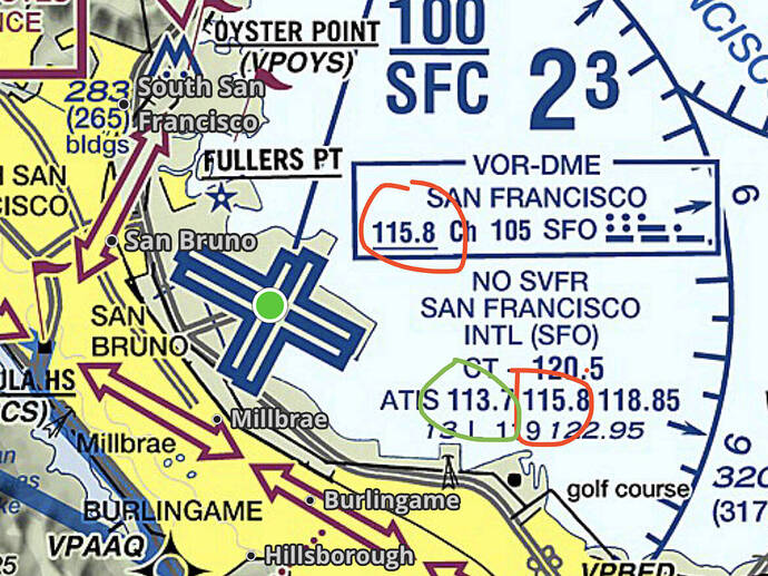
There are a number of airports that you can not pickup until you are within 30 miles like KSFO or KORD.
Yep, for all intents and purposes, the sim only defines a roughly 40-60NM range for ATIS.
D-ATIS isn’t available. The best iteration I do in-cockpit is check weather at the Destination using Little Nav Map, which is reading in-sim WX conditions, and recommends best runways with head and cross wind readings. All things being equal, I plan for that runway heading understanding that the assigned Approach may not make sense in some cases because the airport BGL file has a “preferred” runways override.
I’m talking real-world. There are definitely limitations in the sim (and I am by no means aware of them all), but in a perfectly simulated world it should match real world and follow suit.
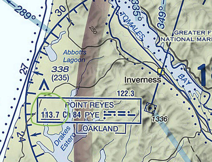
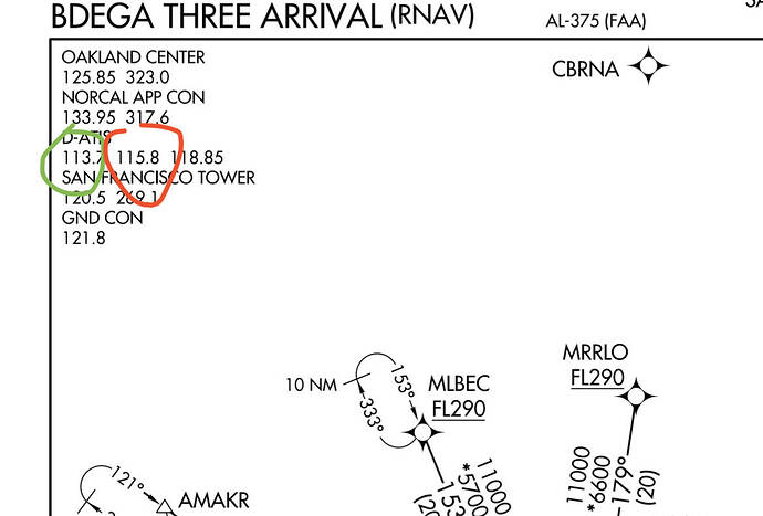
IRL, you can actually get KSFO ATIS from the SFO or PYE VORTACs. See this (quick and dirty):
So you guys are saying that airlines are not checking on the active landing runways and entering the most probable STAR and Approach into the FMS before departure, or very early in the flight?
I mean isn’t the STAR that you choose usually very connected and specific to the rwy you will land on? That’s why it’s nice to know the most probable procedure beforehand. It’s kind of late to get the rwy info when you are finishing the STAR.
Oh well, I’m not a pilot, I’m just thinking out loud.
Anyway, I usually use the wind information given in the world map to choose a suitable runway for departure and landing, including SID and STAR.
It depends on the airport.
Some airports have “all rwy” STARs and the selected STAR is usually part of the flight plan.
Other airports have transitions with multiple STARs coming off of each transition, depending on the landing flow. For these airports, the flight plan, and clearance limit, is usually the transition to the STAR.
Tower has to give Approach and nearby Center sectors a 30 minute to 1 hour warning before switching configurations.
Typically, it’ll go something like “switching to landing south at 1730z.” Center controllers are very good at knowing how long each plane will be on approach and deciding when to “switch” to the other runway STARs.
Atis will typically indicate the new configuration about 5 minutes early (10 at airports with long taxi times) but may indicate a planned switch as well. Sometimes they’ll put a planned switchover in the ATIS.
Other airports, such as my home airport, simply tells Approach of their intent to switch active runways and Approach starts vectoring all new arrivals to the new runways. Tower then updates the ATIS at that time, and starts sending departures to the new runways. Completes the last few landings and maybe a departure or two on the old configuration and then switches.
No, what I stated is ATC in-sim doesn’t even know what a STAR is from a procedure leg type. So it’s not able to sync scripts to prompt a correct descent and routing from your original flight plan.
For gameplay purposes, you can still select and fly the STAR, but it won’t sync up with ATC.
STAR - most likely planned, dispatched, filed, usually part of the route clearance, and if so, entered into the FMC. Can be amended in flight.
Approach - can be considered, but never filed (you couldn’t even if you wanted to, however you can file to an IAF or feeder fix, or a STAR that will dump you off onto an approach). Most likely not entered until you get close to the arrival airport.
Remember this is all somewhat airport dependent, and some airlines have specific Op Specs and many ATC facilities have Letters of Agreement (LOA) that can help you guess with a fair amount of certainty what you’re going to get, based on your airline and equipment.
But if you’re General Aviation (like in a TBM), I wouldn’t ever plan past the STAR - consider, but not plan, until you get the instructions. You’ll be at the whim of the weather and whatever traffic flow/workload is going on.
The ability to accept a change in routing, STAR, or approach on the fly is a big indicator between those with experience or proficiency and those without. And the act of actually doing the change can cause problems, even with professionals. Go read some NASA ASRS reports filtered for LAX. A good chunk of them are “ATC gave us a late arrival/approach/runway change, and while I had my head down reprogramming the FMC, I blew our crossing restriction.” Or “we got too close to the aircraft on a parallel approach.”
But as @CasualClick says, in the in-sim ATC, it’s all kind of messed up right now with regard to STARS.
There are also minimum speed and height conditions for a STAR. Many GA aircraft performance envelopes fall well short of the speed, descent and altitude change requirements. STARs are primarily to deconflict and route volume traffic into a small airspace around the field -i.e., jetliners. Even some light BizJets can’t meet some of these requirements.
I think the point is, and what makes it germane to the thread, the sim is allowing us to do things in the world map that generally aren’t done in real life. And by giving us a neatly packaged flight plan, which isn’t exactly realistic, is producing some unexpected behavior in the navigator.
Just in case, this can be wrong if there’s a hiccup with the weather service - LNM reads the METAR data from source(s) specified to it, NOAA by default, while the sim has its own provider in meteoblue (METAR bubbles included).
It would be marvellous if there was an API to read the sim’s weather, but currently it seems to be in the backrooms if possible at all (as shown by the weather radar development)
(I’m being picky since this is a newbie-friendly zone)
This mostly applies to the Cessna TBM9
Nav mode turns on but it has to do with the most recent AAU1(?) update. I have to do a manual “direct to” to the first waypoint after I set everything up via the FMS. After the first set of “ departures” waypoints, the next set of “ arrivals” waypoints comes up and I have to hit it manually via the direct to. But it’s like 60+ miles the opposite direction and won’t turn to it.


