Glideslope Glideslope Glideslope

I am getting really sick of hearing Glideslope Glideslope Glideslope so much when I’m on a pretty much perfect path.

Is it the developers fault for not programming the ILS correctly? Or a problem with the base sim?

I live in fear of what will happen if I have to do a Cat iii autoland. I fear it’ll slam me in to the ground before the runway, or send me halfway down then I’ll run off the end.

I really wish this would be fixed so it didn’t happen.

1 Like

Hi @dectenor1 ,

Thank you for your post! Your topic has been moved to a sub-category of the User Support Hub

The General Discussion category is meant for discussions that fall outside of our other sub-categories.

If you would like other users to help you with an issue you are experiencing in the sim, consider these User Support Hub categories for your future post:

User Support Hub > Aircraft & Systems
User Support Hub > ATC, Traffic & NAVAIDs
User Support Hub > Crashes (CTDs)
User Support Hub > Hardware & Peripherals
User Support Hub > Install, Performance & Graphics
User Support Hub > Scenery & Airports
User Support Hub > User Interface & Activities
User Support Hub > Virtual Reality (VR)
User Support Hub > Weather & Live Weather
User Support Hub > Miscellaneous

With which aircraft are you getting that alert ?
Could you provide steps your are following so that community can try guiding you through the correct procedure.
To my knowledge, no such issue has been reported.

1 Like

I get the same issue most of the time flying into KDAL on short final to RWY 13R right before Bachman Lake. I use the PMDG B737-700 and am right on the glideslope. It is a bit unnerving hearing Glideslope Glideslope while on the GS on short final.

Did you bring that to PMDG’s attention?

It’s nothing to do with different aircraft, it happens with many aircraft. And it is certainly not to do with any procedures I need guiding through, but thanks for the offer.

You can see it on many streamers videos as well. And real world pilots have made YouTube videos specifically highlighting the issue and saying that the glides and papis are poor in msfs.

See for example Cpt Canada’s video from only yesterday at 5.20.20

See for another example this video talking specifically about this issue.

FYI, this is the feedback-logged PAPI bug report:
PAPI and VASI lights have wrong placement, causing long landings, or are missing

Thanks.

The glideslopes are often wrong as well though, as seen in the first video that I linked.

The first step would be to know what is causing this…

(i) Is it a problem with navdata?

(ii) Is it how the sim codes glideslopes and papis?

(iii) Is it a problem with how the aircraft are displaying this data?

(iv) Is it a problem with how scenery developers have made the airports?

Once we know what causes the issue we can begin to fix it.

On the 1st video, glideslope alarm starts when plane is clearly flying below the glideslope, so this is correct:

And agree with @SmotheryVase665, issue that leads to that is related to incorrect PAPI placement, in case pilot follow PAPI instead of glideslope (can’t say if it happens at all airports).
The issue is almost for sure among the points you listed. Since the bug report is feedback-logged it means devs have it on their list to review.
So to avoid the alarm, better follow the glideslope meantime they fix the PAPI issue.

1 Like

Yes the plane is below the glideslope and hence the alarm but the glideslope in this case looks to be far too high or the display is far too sensitive. The aircraft seems to cross the threshold at about the correct altitude yet the glideslope is off the display.

I will fly this approach later with an autoland and see where the glide takes me.

See also this shot.

The aircraft is beyond the threshold and displaying 70 ft AGL. This means the aircraft is too high, one should be 50ft AGL over the threshold, and yet the PFD is showing the aircraft to be well below the glide. It should be the complete opposite. At 70ft when you should be at 50ft means you are too high and therefore the you are above the glide and so the glideslope should be shown below you.

Both the glide and the papis are generally unreliable, sometimes one is correct and the other isn’t, sometimes it’s the other way round, sometimes both are incorrect, and rarely both are correct.

2 Likes

Agree, could also be an issue with the glideslope at some airports if you can determine that the touch point is too far on the runway.

Yeah. I’m afraid I just don’t know how the glideslopes work in terms of where the data comes from and how that is transferred to the aircraft in the sim.

It could well be just errors with scenery. But some of these sceneries are from very well respected developers.

I seem to be pushing the glideslope inhibit (or it’s Boeing/Airbus equivalent) button on every other flight almost to stop the glideslope warning when I can clearly see I am good on the path. I don’t ever recall doing this in previous sims which also had sceneries by these developers, so I’m dubious that they’ve suddenly lost the ability to be able to programme a glide (if that even is the scenery developers job) as soon as MSFS came out.

But it’s just speculation on my behalf as I don’t know how it works in the sim, what’s not speculation is that there is a problem though.

Hopefully something can be done about it. But I’m sure if it’s an issue with the sim it will already be baked into 2024 by now.

2 Likes

I’ve been complaining about this since day 1 of the sim and have recently been doing a LOT of corrections in the World Hub, which makes for a lot of correlation to my original observations and rants.

I’ve narrowed the problem down to two co-meshed things:

  1. The database they used for runway lighting is from somewhere around 2008. Since then, a lot of lights have changed (specifically many VASIs have been replaced by PAPIs, as well as many additions and changes to approach lights in general). This thread covers that.

  2. Then, when a VASI or PAPI (VGSI for short) is specified, they are placed in a default position of about 1000’ down the runway, no matter the size of the runway. This is wholly inaccurate to reality, in which VGSI are kind of all over the place between a few hundred to 1000’ or so down the runway. This is especially apparent at smaller airports and/or shorter runways, causing gross overshoots, whereas the default position often works okay for larger runways.

That said, there are caveats in that not all VGSI are coincident with the glideslope (often annotated as such on an approach plate) and that not all aircraft will be compliant on the center of the VGSI glidepath anyway, due to fuselage length or cockpit height. Originally, this is why the 3-bar VASI (V6 or V16) was designed, which incorporated an upper and lower glidepath. However, those types have fallen out of favor (only two or three V6 remain in the US - I think at Roswell and Albuquerque) and flying three white on the PAPI will accommodate longer/higher aircraft in their stead.

Oh, additionally, I’ve seen some airports in which the elevation data or runway slope (or lack thereof) messes up the glideslope. There was a thread about this a while back - might have actually been addressed on my PAPI rant thread. Either way, in that case, the glideslope antenna was geographically correct in lat/long position and altitude, but the scenery flattened the entire runway instead of a gentle slope down toward the approach end. Thus, the glidslope was positioned almost 100’ underground (or something like that) while the visual glidepath was based on the wrong altitude and negated any slope, regardless. So yes, the navdata are generally correct, but the scenery, from which the visual glidepath is derived, might not be.

This is before you take into account the trees that often penetrate the runway clearance plane. Sigh.

The implications are mostly bad-habit forming and nothing hurt but pride. But to those of us who try to take it seriously, perhaps as part of keeping our instrument procedures fresh, it’s problematic. Wrong runway lights, four reds, etc, are all grounds for a go-around.

3 Likes

Did that same approach as CptCanada but with an autoland so the aircraft followed the glide exactly.

You can see that it brings you in too high by checking the altitude when crossing the threshold. So the glideslope is erroneous.

Maybe the papis are correct on this approach… It’s impossible to know which to follow until it’s too late.

The PAPI threshold crossing height (TCH) should be 73’ (AGL). The GS should be 55. It already looks like you’re too high, just by geometry alone. At first glance, I’d almost say the glideslope is erroneous here.

I have same issue on most of the airports. I’m not getting glide slope warning when I’m on path but if I follow path to touch down in most cases I overshoot touch down. On some airports I can go a bit below glide slope around 50ft without warning and hit marks but not always possible. Glide slope warning below 100ft inhibits radar count down so landing is way harder then. I’m flying only 737 from PMDG from airliners don’t know how default planes behave. Same story I had with Aerosoft CRJ

2 Likes

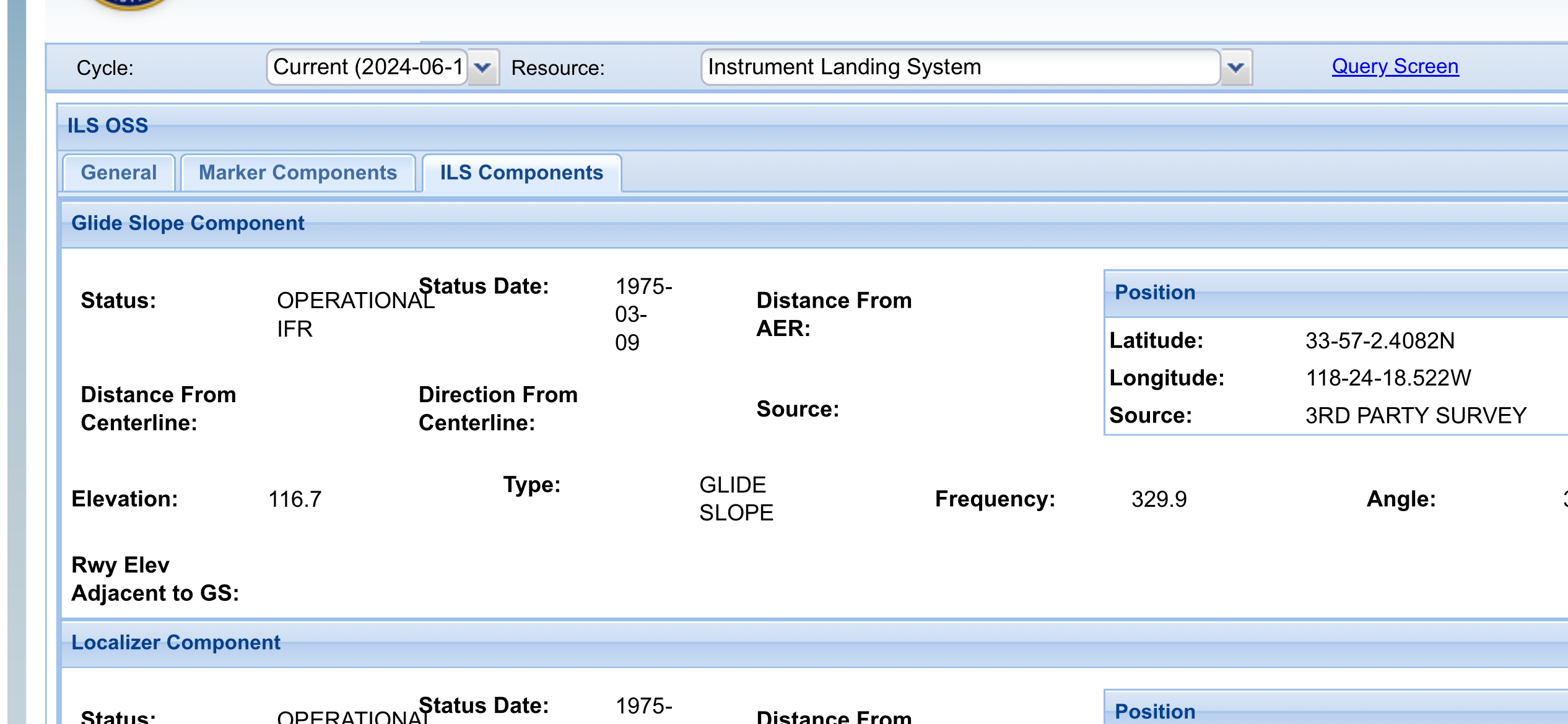
I have a utility program from FSDeveloper that can display the data encoded in the Nav BGLs, and I have compared the LAT/LON and elevation of the KLAX ILS 24R ILS glideslope with the official data from the FAA at enasr.faa.gov and the MSFS GS is exactly correct in both default NavBlue data and Navigraph replacement core navdata.

Here is the official FAA record:

Navaids in MSFS are automatically placed (at least for default airports) by the core navdata BGLs. I have looked at many airports in the US in MSFS and I have never found a localizer or glideslope that is incorrectly placed either in terms of LAT/LON or elevation per official FAA records.

I can not say the same for other parts of the world, as I do not have access to an official source of navaid data that is the equivalent of the FAA’s ENASR.

Glideslope or localizer antennas that may appear in the airport scenery are just objects that are placed in the scenery by the developer. They may or may not be placed correctly, but the simulated ILS localizer and glideslope do not come from the location in the scenery where those objects are placed.

The same holds true for PAPIs. There is not an official database of exact PAPI LAT/LON as there is for ILS localizers and glideslopes. They have to be placed by the scenery developer, and if they are not in the correct real-world location, the visual glidepath may not correspond with the ILS glideslope.

It should be noted though that at quite a few r/w airports, the PAPI glidepath and ILS glideslope do not match. There will usually be a note about this on the r/w approach chart when this situation exists.

Now, scenery developers who build custom airports can create custom navdata that will override the default data, in which case it is up to them to get it correct.

There are several factors that can cause glideslope errors in MSFS even though the actual glideslope is placed exactly right per FAA data.

When a runway is created in the SDK scenery development interface, the developer has to specify the exact LAT/LON of the runway threshold, its length, width and magnetic heading. If any of those are wrong, then ILS components may not line up correctly. Runway touchdown zone markings are another potential source of errors. In the “standard” airport scenery development interface, runway markings are automatically created based on the type of markings (precision or non-precision) and are placed a standard distance from the runway threshold.

Developers can create custom runway markings, but that takes considerably more work.

Another potential source of errors is if the elevation of the MSFS terrain is incorrect. The ILS glideslope transmitter is paced at a specific MSL elevation per the FAA data, but if the elevation of the runway surface is wrong in the base MSFS terrain, that can make the glideslope radiate either from below ground or too far above ground, so the point where it intersects the runway touchdown zone will be wrong.

I wonder if that’s the issue here. I’m not around a computer to check, but can later. Also, have to confirm no third party scenery. Either way, being on GS for LAX 24R should give you a low PAPI indication, whereas this is reversed.

Not sure how to check that. The scenery developer is responsible for placing the PAPI in the correct location.

As far as the OP topic, I don’t know why anyone would get continuous “GLIDESLOPE GLIDESLOPE” warnings if the GS diamond is centered during descent. Whether the point where the glideslope takes you on the runway is right or wrong, you should not get that warning unless the aircraft has dropped below the simulated glideslope, in which case the diamond would move up on the nav display.

Wasn’t the problem that following the PAPI would bring it under the glideslope? In this example, that would be the case, where in reality it should be the opposite on this runway - being on the PAPI should produce an above-glideslope indication.