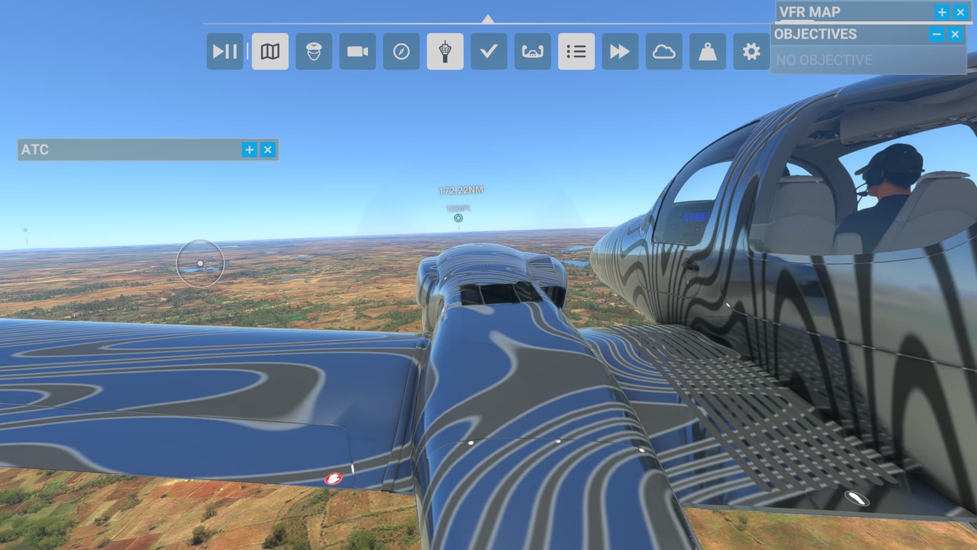
Recently I started a full circumnavigation trip in the Diamond DA62. I started at Catalina Airport and am currently in Italy. So far I have flown these 18 legs:
|KAVX (Catalina Island, CA)|KSEZ (Sedona, AZ, USA)
|KSEZ (Sedona, AZ)|KABQ (Albuquerque, NM, USA)
|KABQ (Albuquerque, NM)|KICT (Wichita, KS, USA)
|KICT (Wichita, KS)|KMCI (Kansas City, MO, USA)
|KMCI (Kansas City, MO)|KORD (Chicago, IL, USA)
|KORD (Chicago, IL)|KLAN (Lansing, MI, USA)
|KLAN (Lansing, MI, USA)|KPQI (Presque Isle, Maine, USA)
I am fairly inexperienced so I have had some assists on for certain legs, like unlimited fuel for the longer legs. I am, however, not using live weather or worrying about which airports have fuel and all of that. Also the autopilot is on almost always, a lot of letting it run while getting other things done.
For the rest of it, I plan to head down through through Asia and then down to Australia before jumping across to Hawaii and then to Catalina. The last leg from Hawaii to Catalina is 2215nm and is estimated to take over 14 hours.
So I’m wondering, for those who have done something like this, what rules should you follow to create the most authentic version of a circumnavigation in the sim?
Hi, I have done it twice in the longitude. Each time I went westbound not eastbound and I used live weather and no unlimited fuel. I am just now about to start again in the PMDG DC6. I am based near Charleroi in Belgium IRL (Brussels South) and now I am in Glasgow Scotland. The route I take from Iceland to Canada arrives in Goose Bay via Greenland. Personally I have never gone Via Hawaii always across Asia and Russia via Nome. If you stay near the landmass I was able to do most flights in 2 and a half hours. So lots of hops but quite possible. DC6 has half the speed of the Longitude but I think it will be more fun as I will be closer to the ground.
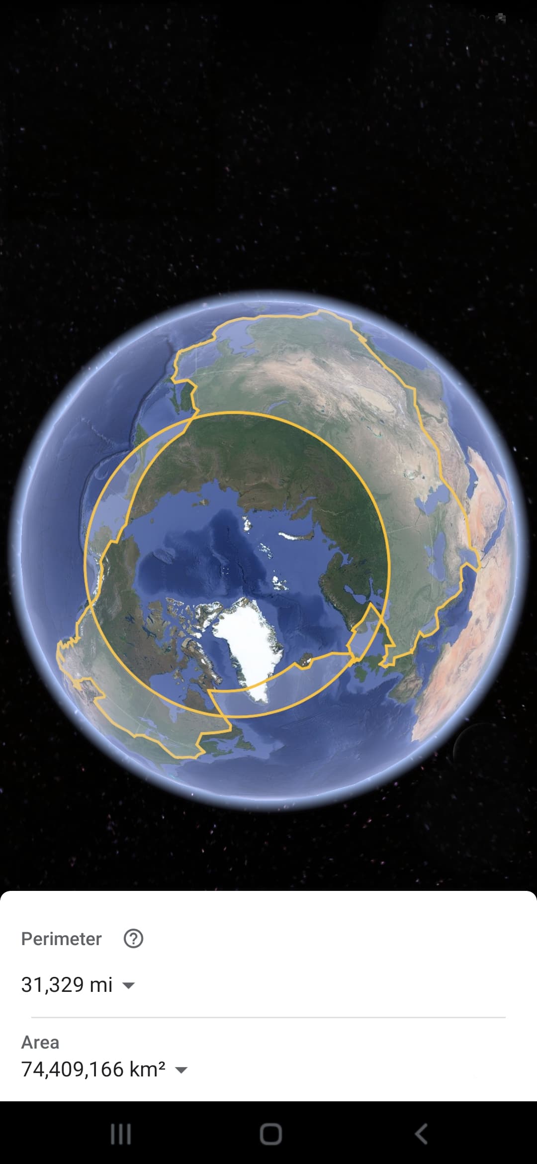
You should enter and exit only on International POE (Port of Entry Airports) if you want to keep it realistic. That does limit your options. For example, traversing Iceland there are two POEs on the East side, but they are only open for limited hours, so you’d have to transit BIRK to one of them so you can launch with max fuel to get to the Faroes or even the UK.
A year or so ago I took the time to fly around the world in the SR22. I, also, went Eastbound. My route from the UK to the USA went down through France, along the spine of Italy, across to Greece and then through Turkey.
From there I weaved my way across the Middle East and down to Dubai. From there I headed North East and along the southern coast of Pakistan, across India and then down through Asia to Singapore. I continued SE to Indonesia and then up to the Philippines, Taiwan and up the spine of Japan and followed the airports that run North East from RJCM to UHPP and then across the Pacific to PASY and made my way along the islands that run up to the SW tip of Alaska.
I have only included that part of the trip that is relevant to where you are now in your current round the world trip.
The total distance for my round the world trip was 19958 NM and the total flying time was 112h44min. I used LittleNavMap to plan my route and it helped me keep logs for each leg of the journey.
I may consider changing my course to go through Alaska though, I’m sure that would be more enjoyable. To make it a true circumnavigation, so perhaps head north up through Korea after getting past the equator in Indonesia. It wil definitely be longer but surely more scenic and enjoyable.
I’ve completed one RTW in the TBM 930 and am in the middle of another. The first was seat of the pants stuff, largely made up as i went along. You can read about it here:
And you can read about my latest adventure which involves visiting every capital city in the world
The most important thing is to keep it fun and not a chore!
That YouTube series is what inspired me to try a round the world flight too (at least in the sim we don’t have to take ‘comfort breaks’ using bottles - although it’s still an option, mind you!)
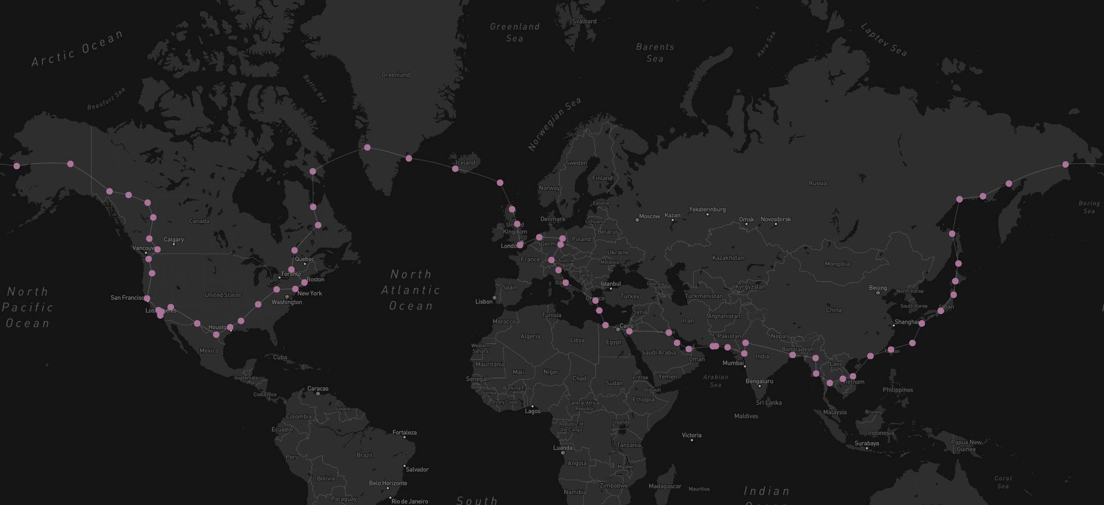
I started mine in the C152 not long after the sim came to xbox, although I did have previous experience with prior MSFS’s and Xplane. Going east from Edinburgh, Scotland it took me around seven months.
The rules I set for myself included: no assists except on longer legs eg. flying up the east coast of Russia and the Aleutian Islands and crossing Greenland, were I used unlimited fuel. I also used live weather except where it would prevent me flying VFR (the trip was largely focused on sightseeing in the new sim). I also almost completed ignored airspace restrictions (again, for the eye candy).
I have a rough google maps image showing my route (minus the extra circular line, whichalso knockedof the distance), but no flightplan to share as I’m on console:
Just to add. Thank you for initiating this post. For me, it represents the essence of what msfs2020 has done. Give people the ability to explore and be curious. Just to add round the world with the top gun maverick darkstar possible in about 10 hours. @CasualClick@tamalien and the mods. Thanks for your comments and interactions. For me your interactions on posts like this one are very welcome. You tie the community together. Good fun chatting about going around the globe. Thank you very much!
For what it’s worth been around a few times following @FootanMouth world tour, he’s got a master post of the first trip around here [Foot] World Tour it was pretty awesome (good luck with canada inside joke we never seen the ground lol ) it’s still on going 3rd time round now lol
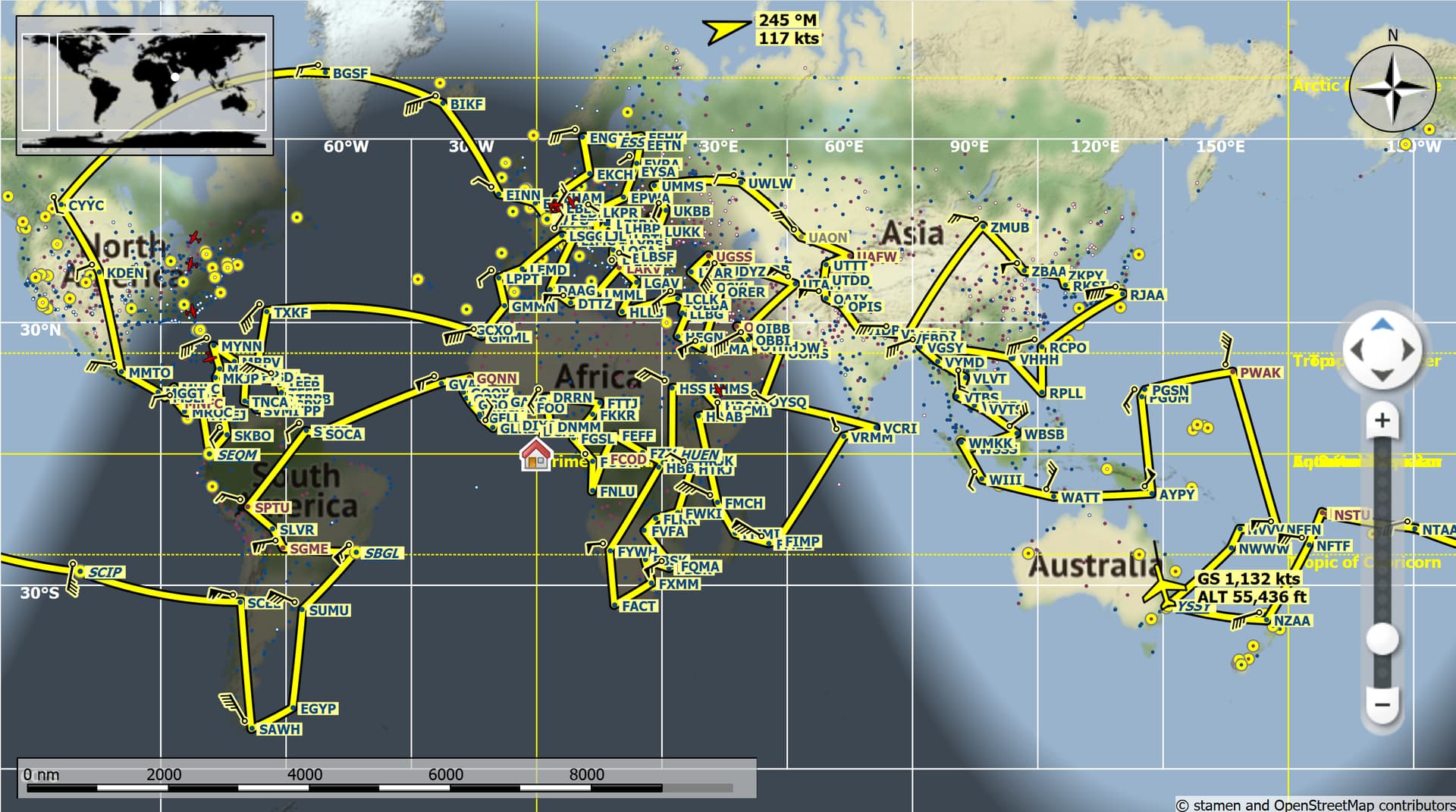
I recently completed a 202 leg RTW trip in the Concorde, every country with > 8000ft rwy + VQPR, no assists, live weather, day time allowable. Took me about 4 months.
About two years ago I began a trip following the route of Amelia Earhart. I used the Beech G36 at the time because it was the only aircraft available in MSFS that came close to the actual cruise speed of the Lockheed 10a. (Perhaps a bit faster).
I simulated each of her historical legs, to include the leg to Howland Island and her planed legs she never completed (yes I found Howland Island in MSFS and landed there). It took me little over a year to complete but was quite interesting, especially researching the old airfields that she used. Some still in existence while others not.
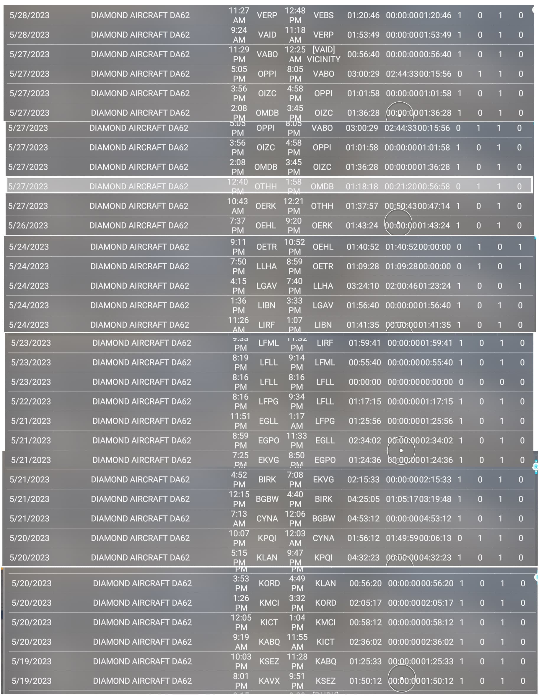
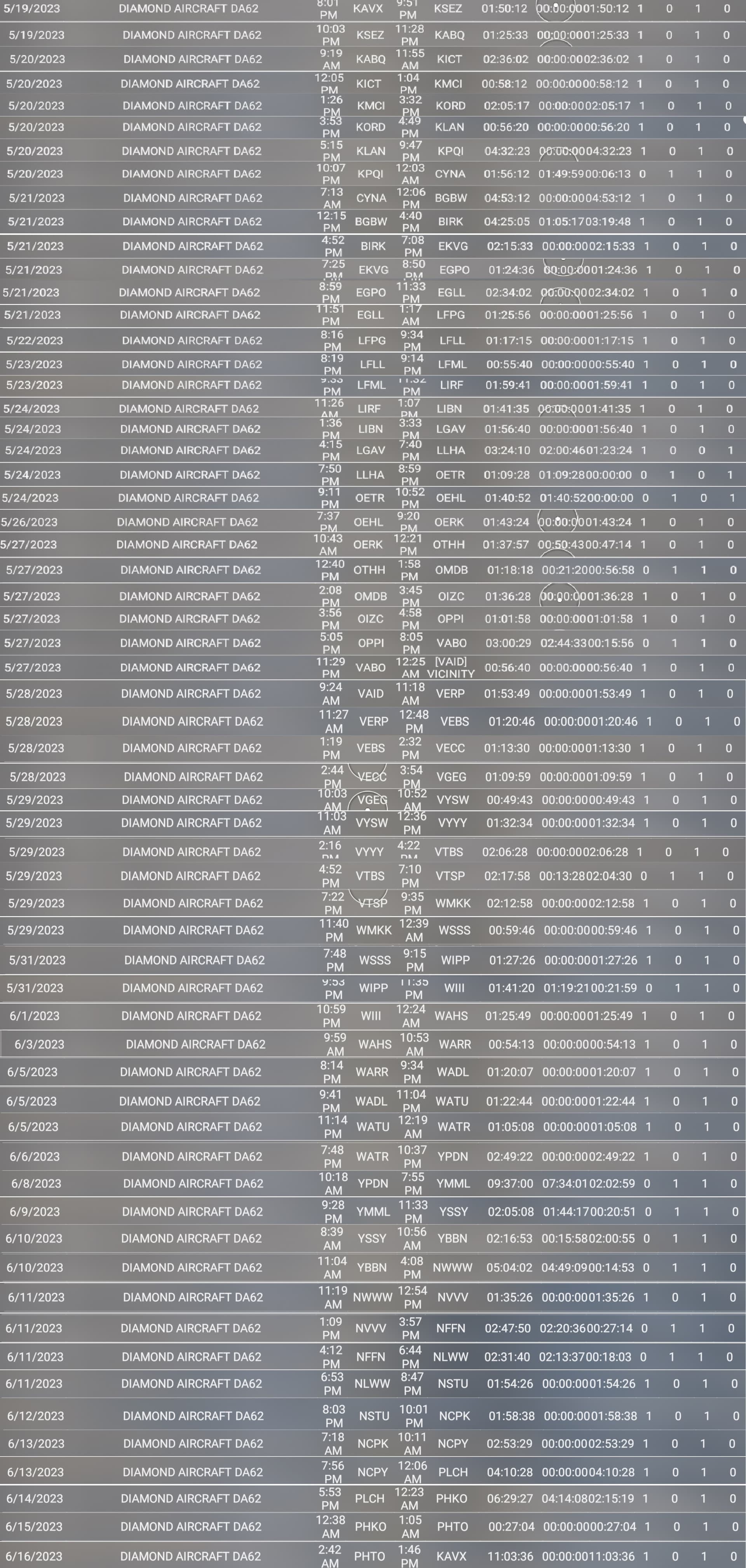
I recorded each leg with time and distance in a log book.
Total Time was 141h16m24sec
Total Distance was 24,109.8NM
Only airport I had trouble with registering the landing was VAID, landed following the pattern just like every other landing but it only registered as vicinity.
Going to try this again in another plane and a different route, likely the one posted by @DNBOF