I’m a new player and not very familiar with terminology so apologies in advance if anything is wrong.
I set up my IFR route on the world map using the EFB. When I started my flight the same route was still present on the EFB, but the route on the plane GPS was just a direct line between the two airports. The autopilot also only followed the direct line route.
Have I made a mistake somewhere or am I misunderstanding how it works?
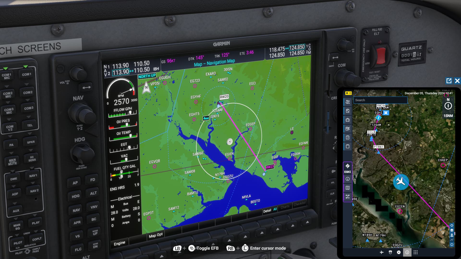
The two flight plans do not appear to be the same. If you look at the magenta path on the EFB, it looks like it has a departure procedure shown. The map on the PFD on the left looks like it is just a direct path between airports, no other waypoints.
So there seems to be a mismatch between the plane’s flight plan and the one shown on the EFB. Perhaps it didn’t load into the plane properly for some reason.
The EFB/ATC plan will look different because it originates the course from the pattern exit, which may be a mile or so from the departure airport. Whereas the GPS draws it from the center of the airport. The GPS won’t do any of the traffic pattern waypoints at either airport except the initial entry at the arrival airport.
You can, however add enroute waypoints to the EFB then sync it using “file with ATC,” which changes the blue path on the map and blue boxes in the sim. Then also “send to avionics” from the EFB, which again will load the enroute waypoints and the initial pattern entry into the GPS.
I tried using ‘send route to ATC’ and ‘send route to avionics’ in both the world map and using the EFB in the sim. It works on the world map but had no effect on the GPS route. Do I have to then change the CDI(?) on the GPS to follow a different route?
Basically the route I see on the plane GPS is just a straight line from airport to airport. The route on my EFB also shows my landing pattern. I’m able to use the EFB for manual flight but I’d love to load this detailed route into the plane GPS so that my autopilot can follow it. Currently if I enable autopilot, it just follows the straight line on the GPS.
Yeah, the GPS doesn’t currently render all the departure and arrival VFR pattern stuff (nor should it, really). The EFB will create a user waypoint at the pattern entry and that’s about it, everything else is working “as it should” as if it were the real world. I imagine that trying to force the Garmin, which uses a near-facsimile of actual Garmin logic (that doesn’t do pattern paths) to use outside logic to create an appropriate path around the pattern would break things. So your paths aren’t exactly going to match.
My advice is to either ignore one or the other - I’d choose to follow the Garmin for the sake of realism. Better, you can setup a keybind that hides the blue boxes, which you can re-activate as needed, especially if you want to visualize the pattern geometry as you approach.
I don’t think that’s necessarily the case. I think it’s more understanding the differences between the EFB, which uses/creates imaginary navdata to suit any user’s needs and the Garmin navigators, which are programmed to mimic real-world operation as closely as possible. The two won’t always align, and dare I say other types of navigation computers like FMCs found in Airbus and Boeing planes won’t, either.
If you’re looking to fly standard arrival and departure procedures, the Garmin will do it, but only if they exist. Part of the issue is many airports, especially smaller ones, don’t have those, and they often don’t even have instrument approaches. Hence, the made-up visual traffic pattern geometry created by the EFB which Garmins simply don’t have.
I think it’s better education and managing expectations than anything else. But in the end, it’s probably more about the airport you choose rather than the airplane.
I see, so it’s more a limitation of the airport than of the GPS?
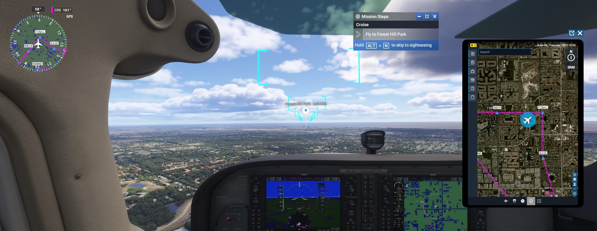
I guess the solution is just to use the EFB to manually fly the departure and arrival procedures, then I can use autopilot just to follow the main line between the two airports. Do the blue boxes represent the route on the EFB or the GPS?
The blue boxes are the suggested route from the EFB. I don’t fly through them during cruise. I create my own route as best as I can through the G1000. I’ll use the web based official flight planner and SkyVector to help with planning.
I’ll use the blue squares as a suggested pattern when the airport doesn’t have an RNAV or LNAV approach available, but I find those blue boxes want you to come in way too steeply for landing.
Some flights I’ve only flown through one or two blue squares and got S tier mission completion still.
Yes, this is another bug. The same thing happened to me today.
As you can see in the image, the plane is perfectly aligned with the flight plan route on the avionics screen but in the EFB, even though the plane is correctly positioned, the flight path is shifted to the left.
I can’t believe this wasn’t detected in the tests that were supposedly done by Asobo’s internal beta testers, before the simulator was released.
There’s a long explanation of this on the Working Title Discord server. Too long to post here, but it’s due to how the arrival is drawn at the destination airport, and it does not seem to be a bug.
Thanks for the info. I’ll look into it when I have more time. (I spend more time reading than flying, unfortunately.)
I don’t doubt there’s an explanation, but for the user in the end, it’s a bug that both devices don’t display the same information.
What should we trust then?
The flight plan in the MFD doesn’t show the VFR patterns used for departing and arriving. It shows the path from the departure airport runway to the arrival airport runway.
The flight plan in the EFB does show the VFR patterns and is linking from the departure pattern exit to the arrival pattern entry.
When you fly the GPS line in the MFD, are you flying through the blue rectangles? The blue rectangles are the flight plan from the EFB.
So technically the MFD and EFB are both correct because there are two flight plans being represented. So it’s not a bug.
That is happening with me aswell! I create a flight plan on the efb but the avionics only show a continuous straight line. Anyone knows hotel to fix it?
I am as new to FS as I can be, but I realise that, others have said, the departure procedures in the EFB are not followed by the GPS. The routes eventually coincide but because the destination is the same. The GPS takes the plane on a straight line to the first waypoint right after take off, although in the map you can see that it is suposed to follow a different route. It is important since you may encounter unexpected obstacles on the straight route. I almost crashed into a mountain range when the plane was suposed to follow the coast line arround it.