So the big draw of MSFS2020 is usually the epic scenery, but I’ve gone down a very unscenic rabbit hole with practicing in IMC conditions. And especially recently, working to hand fly those scenarios without waypoint reference—just using VOR/localizer navigation. My first attempts were a huge mess of constant oscillating altitudes and banks, but repetition has been helping improve the instrument scan and one of my biggest issues, trimming the aircraft at every configuration change.
Video of one of those flights a couple days ago using the Zero Visibility setting in Weather Preset Pro at Pulliam Airport, Flagstaff, Arizona, USA / KFLG. The flight departs on the Flagstaff One departure and returns on the ILS Runway 21 approach. That gives an opportunity to juggle three VOR stations to establish fixes plus the localizer.
A couple areas I need to work on — my procedure turns need to tighten up so I can meet my fix and inbound course in the one-minute time frame. Plus greater care on pitch during turns. I’m using a flight stick instead of a yoke, so I think that may be part of where I’m introducing slop. Should be able to better control that though.
If anyone else is hand flying these scenarios through IMC, I’d be interested to hear your experiences or what kind of departures/routes/approaches you’ve been practicing on.
MODERATORS: If this is not the right place to post this, please let me know.
I enjoy handflying IFR procedures; I’ll usually look for the lowest weather where there’s Vatsim coverage and go ask for practice approaches.
So much depends on the flight model of the aircraft you’re in. I don’t have the bandeirante so I’m not sure how stable it is… my current favorite is the Kodiak (with the flight model mod, though that’s mostly for realistic flap drag in the bush… it’s stable enough stock.) But yeah, you want a fairly stable platform.
You don’t have to worry too much about that 1 minute holding pattern; this isn’t a navy marshall stack where you have to hit your push time within 10 seconds ;). You’ve got a large slice of protected airspace in a civilian hold, and as long as you stay within that, ATC doesn’t care what you do there. You could do rolling circles for all they care lol. The one minute inbound leg is just kind of a rough guide, though of course it’s satisfying to nail the wind correction and hit it right on.
Honestly, this sim is fantastic for learning/practicing IFR flying… the weather depictions and lighting in IMC are really second to none. I don’t understand why people seem to dismiss it as a VFR-only sim… in its current state, it’s the best we’ve ever had for this kind of thing.
Always good to be able to handfly any IFR procedure. Folk dread having to fly holds on vatsim if their aircraft avionics don’t have automation…but it’s not that hard. You just need a clock…and know how to enter it of course. Mr Marchacio taught all this well in FSX.
Well, i definately see a way of helping you with the approach…
As you depart the airport, you are using the airport DME to guide you out towards the NM-marker before you turn into your teardrop. You can use that same DME on your approach coming in from the north-east onto final. You are using the DME/localizer to guide you to the 35.7nm Zamab, but not using it to get yourself dailed onto FIMAL (10.2nm @ 10.200Ft) where you should start your descend and then doublechecking at HEVMU (4.9nm @8500ft) that you reach that crucial 8500 as you are continuing your 500-700 feet descend rate…
I’m not a real pilot, but you are using the other localizers perfectly, but in the critical phase of landing, (you know, trees and rocks that appear out of nowhere ) you donot use the NM-Altitude-references from the approach chart.
Yer doing an awsome job btw…or do you have the Fimal and Hevmu DME NM’s on the other (right) screen
Check the bottom part of the Jeppesen-chart for the altitudes. At the last 1000 above runway, you look up to spot the airport, at 500 without visual of the runway, you should break off and go around as far as i know… trying to land on just the centering needle and guestimating the descent rate is very dangerous, that’s why they have those inbetween spots for reference. LOWI also has an awsome manual approach… if you decend before the waypoints, you are hitting the mountains, so always hit the altitute at the waypoint that the jeppesen charts tell you. (good thing his is a sim, or i’d be dead a thousand times practicing this magical thing called instrument navigation )
Hope it helps your experience. This is the awsome piece about Flightsim, which i’ve loved to learn.
Have a great flight Captain!
Woof ~ Woof & Salute on a succesful landing!
Steiny
PS, i’m not an expert, nor am i an instructor, (well, only on a garbagetruck) so i hope i used the right terminology to help you along… just noticed there’s that one tool that you are not using, even though flying everything manual… i love that stuff too…
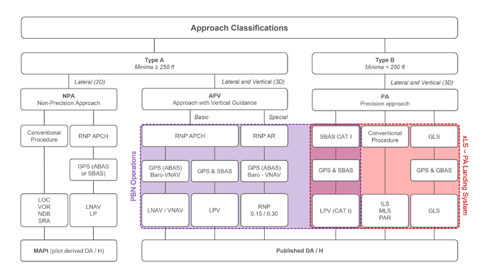
It will depend on if you are on a precision or non precision approach and the class and equipment of the aircraft and the type of approach being flown.
Usually it will be 200ft AGL (or TDZE) for a CatI ILS and an RVR of 1/4nm. This is all specified in great detail in the minimums part of any IAP chart and takes some knowledge to be able to properly interpret.
Good point on the rudder pedals. I’ve been trying to use them for smaller corrections to reduce impacts on pitch as well as coordination in larger turns. But definitely want to be more consistent with it. It’s especially tough with turn coordination for more significant turns because the slip coordinator recenters so fast after starting a turn without rudder, I can’t tell if that’s normal, or a sim shortcoming, but I struggle to use that for accurate rudder. I feel like I really need a discovery flight or two to actually feel it in action. This sim is pointing me in a direction I can’t really afford lol
Hah, great comparison — I don’t have a good sense for what tolerances are in different situations, but hopefully working more on that. I’m figuring the tighter I can get when practicing to do these things to spec, the more room for error I’ll have when other unexpected things like strong wind, turbulence, or some other performance issue jump into the mix.
Totally agree — I’m really getting pulled in by all the possibilities. I love the visuals, but the modeled procedures and systems, including especially IFR flying, are totally luring my geekier tendencies.
I feel that — holds, procedure turns and their entries have intimidated me and I’ve been psyching myself up to just engage in them and get past that initial mental hurdle.
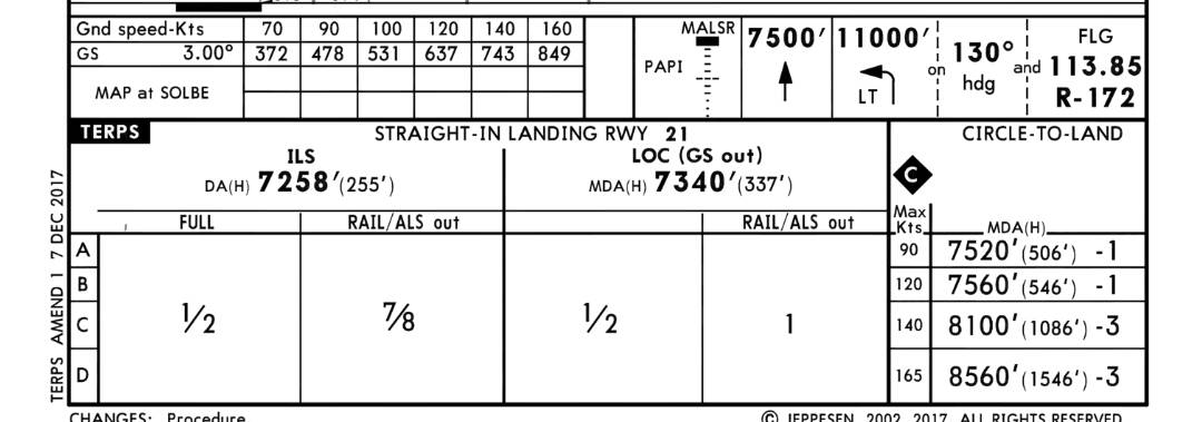
Thanks! This is a great observation. I was noticing this too (too late after the fact) when editing the video and re-reviewing the Jeppesen plate. Item 2 from the header states "DME from FLG VOR/DME. Simultaneous reception of IFLG and FLG DME required. Where I fell down is I was sharing FLG and IFLG on my primary nav. I should have inserted into my workflow to dial FLG into secondary nav standby after I was done with the DRK VOR. Then I could have switched that on when making my ZAMAB turn. IFLG would’ve been on my primary HSI for localizer/glideslope lineup, and then FLG on copilot HSI for quick checks of DME. It would’ve clued me in to my dumb altimeter goof much earlier too. Like, why am reading 10,200 at FIMAL but the glideslope is still above me, d’oh.
I’m probably missing something else here, but I was planning missed approach altitude as 255’ AGL based on the ILS minimum at bottom of the plate and I think I had it spotted at about 1000’ AGL so I proceeded with the landing. But if you get a chance, let me know what you saw there that I’m missing. Thanks for the LOWI recommendation!
Yes, a decision height of 255’AGL for a straight in landing with the runway lighting functional. And a Runway Visible Range of 1/2nm (1000yards). One of the easier minimums boxes to read!
Okay, that’s what I was interpreting. Thanks for confirmation there.
And then side noting over to the Circle-to-land column…even at 546’ AGL & 1 mile for class B, circling to land in conditions like that gives me chills. Pretty sure I’d want to find any other way to land than circling
No worries, i was wrong about the decision height… it’s also in the chart, but i hadn’t taught myself to read that part properly yet… hihihi. Yeah, armchairpilot here.
Nothing to add here, @JPerez1690, i think it’s quite commendable that you’ve done what you’ve done with the limited instruments that you did… in fact, i think it’s quite awsome! The thing that disoriented me most, was my unfamiliarity with the airplane itself.
But, there i was thinking not many people doing oldschool navigation, and yet, there was your post and video Great work!
Oh question though, did you lean the mixture, as you are quite high up at Flagstaff?
Keep on keeping on!
Okay! Just to let you in a little secret: i haven’t studied aviation thát much, but do dive into matters that interest me a bit.. for one, i can read part of a metar, but what you’ve just typed… well: AGL, Cat1 iLS and nm are things i know… the others i’d have to google! (in other words, that’s how far my knowledge takes me right now.) I just dont know how to name everything i see without it getting weird
Most of the things i’ve learnt in FS are from just doing, instead of actually going to flightschool and learning things proper. The flying or navigating is not a problem, the exact wording, however.. hahaha. Yeah, ya got me!
But yeah, officially 200 feet above ground level, added on top of field elevation with the correct barometric pressure sounds about right.
Woof ~ Woof & Salute to you all, you make this forum awsome!
Just wanna make sure, you don’t use decision height on non-precision or CAT I approaches. Only for CAT II / III approaches are you allowed to use minima (DH) based on radio altitude.
I have plenty of material on holdings, DME arcs, VOR and NDB intercepts etc. I will send you a DM and anyone who is interested just sent me a DM and I will forward it.
LOWI is awesome, I have flown many approaches there in real life on private jets, turboprops and training flights with small single engine aircraft. Its a nice training airport. There are more challenging airport out there but Innsbruck is a good start.
Thanks for making that clear. Minima is such a complex topic.
As an aside, I discovered I can retro-fit all my MSFS aircraft with a radio altimeter by mapping the ‘Radio Alt’ simvar to one of my Logitech panel screens. I’m not sure this would meet with FAA approval, however.
Problem with radio altimeter is that it doesn’t give height above threshold, rather the height above terrain. If you use a 200 ft DH on a CAT I approach towards a runway with a 100 ft cliff in front of it you will get the “minimums” call 100 ft above above threshold. For that reason non-precision and CAT I approaches use baro altitude (DA).
For CAT II / III operations the area in front of the runway is specially prepared to give accurate radio altitude for use of DH. If there is no MDA bug the DH bug should be turned all the way down to prevent it from giving misleading minimum callouts.
To make it more complex, all precision approaches (ILS, GLS, MLS, PAR, LPV CAT I) and APV approaches (LNAV / VNAV, LPV, RNP-AR) have a published Decision Altitude (DA) or Decision Height (DH for CAT II / III).
The DA/H has a correction built in for altitude loss during go-around. You make the decision to go-around at DA/H, you then descent slightly below DA/H before positive climb is established and this is absolutely fine.
For non-precision approaches (NDB, VOR, LOC, SRA, LNAV, LP) the published minima is a MDA (Minimum Descent Altitude) in other words you need to make the decision above, then hit 0 ft/min reaching the MDA. In our company we use +30 ft for turboprops and +50 ft for (regional) jets.
At least that is the way it is in Europe. Jeppesen even shows “DA/H” on non-precision approach charts while those are actually MDAs! NavBlue does not specify whether those are DAs or MDAs so its a bit less confusing.
Anyway for non-precision approaches flown as CDFA (Continuous Descent Final Approach), without level off at the MDA, like most non-precision approaches are designed or retrofitted nowadays, you need to add a correction for height loss during go-around to covert the MDA into a “pilot-derived” DA.
Thanks Steiny! I like the challenge, and I’ve grown to be a fan of those steam gauge panels. When I’m simming in the Cessna 152 & 172, I do lean mixture more at this airport for best performance. The Bandeirante is a different beast though—I’ve searched the POH and it doesn’t call for the fuel condition levers to be adapted to different altitudes. I think the Fuel Control Unit automatically adjusts for that aspect.
Thanks very much for sending that over! Just one of the many points I started pulling out of those resources — looks like allowance is made for an extra ten seconds into that initial teardrop entry before the 1 minute outbound…lines up better with what I was seeing trying to make that time outward & reasonably meeting the inbound segment. And reveals a whole lot more digging I need to do to look into for all other different types of precision & non-precision approaches beyond ILS, VOR, LOC. I really appreciate it.
Oh boy, getting a hands-on discovery flight in the EMB-110 would be awesome. Hopefully a standard GA trainer would still give me much better perspective on turn coordination (besides everything else) that I currently have zero experience with.
Just a tip : you are not supposed to fly on the 53° radial from FLG VOR to CALGU. This radial is just to identify CALGU using raw navigation (light gray line).
From FLG VOR, you are supposed to fly a reverse course (33°) then do a procedure turn to get back on the ILS.
Using the ‘old’ MS flight sim saved me a ton of money on my IFR Licence IRL. Flying the ILS and (in those days also NDB approaches at my local airport (EGMC) in cloudy conditions. Also you can practice tons of approaches in the sim before you make any trip. One of the values of ‘Simulation’ Thank you Microsoft for bringing it back to life!

 Engine Operation Explained")