High mountain flying & landings

and now to somewhere different:

Papua-Indonesia
your base is Beoga WACZ

you get am emergency call for your Ambulance Caravan: a blast at the Grasberg Gold Mine has gone bad, some diggers are injured, you have to get them to the hospital fast.

climb with Puncak Jaya Peak (16000ft, one of the Seven Summits) in front of you, continue to the mine rim and land on the uphill dirt road at -4.046867, 137.089085, 14000ft.
Get the stretchers, drop thru the pit into the valley south and land on the soccer field of Tembagapura Town: difficult diagonal approach (-4,141599, 137,090912 050°, 6200ft), full brakes, reverse thrust.
try Live Weather, its usually bad…
The south slopes of the Sudirman Range here are pretty wild even with the current Mesh/DEM. On the way to Kumopa airstrip enterprising X-Cub Pilots might find jungle clearings and riverbeds for some hair-raising landings!

2 Likes

lets stay in Oceania:

Malaysia, Borneo
your base is Kota Belud WBKB

fly thru towering clouds to Mt. Kinabalu, 13500ft (6,066373, 116,572480) one of the most prominent peaks in the world.
A platoon of soldiers on a survival exercise is lost since days in Low’s Gully, you have to drop a rescue party on the rocky strip of the peak plateau:

(I even managed to land on the peak itself after some tries)

circle the mountain, watch out for the missing team at the northern cliffs - and Asobos mesh problems (next week gone maybe? :kissing: )

enjoy

1 Like

and now to somewhere different:
the Andes.
As the peaks there still leave a lot to be desired DEM-wise we mimic commercial operations in the smoother Altiplano where the highest mines in the world are located.
In the past a lot of those mines were served by DC-3s and C-46s - can’t wait to get them in MSFS.

those two flights are for the Caravan again:

Chile
your base is: El Loa Airport SCCF
drop some engineers at
-Mine Radomiri: Dirt Road @ -21,991890, -68,674250 , alt. 10000ft
the ground trembles - emergency call: an earthquake has made the road unaccesible to the
-Aquilucho Mine -21,791386, -68,243954 . alt. 19200ft - the highest mine in the world !
land on volcanic ash on top of the cone where the road ends and get the people out.

on to Bolivia:
Base: Juan Mendoza, SLOR, 12000ft
-Mina Bolivar; staff have set-up a tournament at the highest soccer field in the world, unfortunatley some players have collapsed and need oxygen fast.
pick the bottle up at

  • Antequera town: dirt road near the somewhat overgrown green soccer field (can’t play there…)
    -18,475292, -66,847560 ; alt. 13000ft
    and fly up to the
  • dirt playground at -18,504807, -66,851516 , alt. 15500ft.
    You need to do an uphill landing appr °132, come to a full stop at the bushes.
    23 guys are waiting for a good sniff of cool air…

Peru:
You run a tourist seaplane service on Lake Titicaca with some Icon A5s.
Business is low, so you are happy to bring a nurse with corona-vaccines to some mines that have no landing strips - just hi-alt lakes.

start at your fuel stop Yauri airport SPIY
head off to:

  • Caylloma Mine, land at Laguna Vilafro -15.207520, -71.878254 , alt. 15500ft
    if (!) you manage to lift off again next stops are:

  • Toromocho Mine, Laguna Huacracocha, alt 15400ft (-11.624033, -76.156932)

  • Mina Corihuarmi , Laguna Coyllorcocha, alt. 15500ft,( -12,586009, -75,548769)

you might however decline icy Laguna Ninococha, (-10.458531, -76.762338) , alt 16300ft (!) servicing the Raura Mining Complex…
@Asobo: scenery there (gorgeous in RL) seems somewhat dull and interpolated despite no Bing clouds, whats going on?

2 Likes

New Zealand, Southern Alps

a location-scout has booked your X-Cub. You have to drop him in succession on the highest peaks of New Zealand. He will do panoramic photo-shots with his tripod for the next Lord-of-the-Ring movie, to select the best Misty-Mountains scenery.

Create a VFR-flight plan with the GSP-Coordinates stated below (FROM NZMC - TO NZFJ, and via copy-paste into “search” field & the “add” waypoints feature).

The X-Cub can manage the peak landings (in MSFS for the time being…), some are tough uphills. For restart turn the plane 180° in slew mode until it faces down and apply full power.
You will be rewarded with one of the most spectacular sceneries on earth (see the ocean!), Asobo has done a good job there already.

Base: Mount Cook Airport NZMC

Mt. Sefton -43,682370, 170,044130 , alt. 10100ft, 017°
Mt. Cook -43,597115, 170,142412 , alt. 12000ft, 330°
Mt. Tasman -43,565190, 170,157666 , alt. 11500ft,
Minarets Pk. -43,508271, 170,272164 , alt. 10111ft
Mt. Elie de Beaumont -43,483611, 170,331172 , alt. 10500ft
Malte Brun Pk. -43,561585, 170,304102 , alt. 10490ft

from Malte turn to a heading of 323°, glide down low level over wild Franz Josef-Glacier (-43,473158, 170,197313) to

Franz Josef Airodrome NZFJ

1 Like

airport LS60 Rockfall - Parorng

This place was introduced in Inappropriate Landings the author is parorng and the download came from flightsim.to

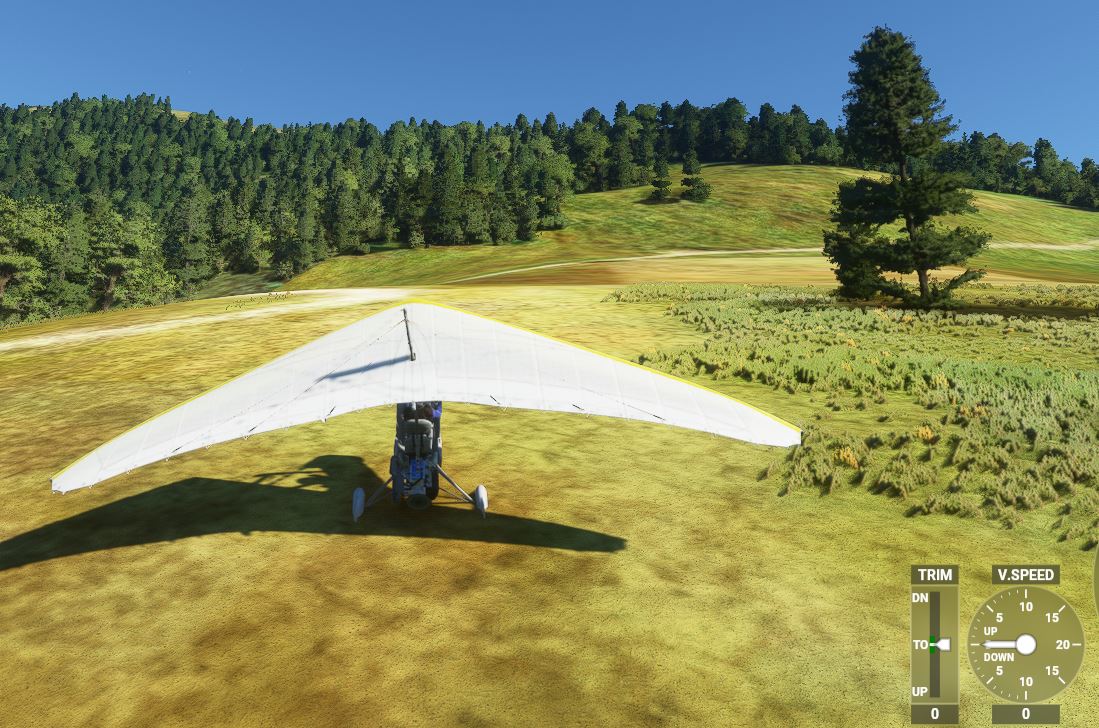
The motorized D-wing aircraft was introduced in a topic that needs more votes !
Come and have a look Paul Falke - Glider, sailplane, soaring, please!

Landed somewhere near… for the nice view :slight_smile:

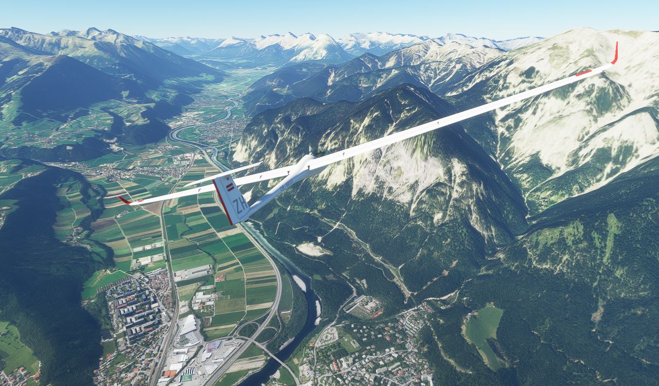
Sail planing above my favorite airport (LOWI Innsbruck 3000Ft, set height with NAV-LOG)


3 Likes

thanx ArcanePython for pointing that out. Downloaded Rockfall - its really tough. I avoided the Alps so far because of its bad mesh.
This morning CET the promised update (UK++) didn`t pop, lets see if Switzerland gets an improvement too during the day (the Matterhorn test).
Saw on “Inappropriate Landings” a volcano trip, I will put one here soon.
Happy gliding!

1 Like

something from the History Channels:

May 9th 1945
Orders from the Politbureau in Moscov:

to celebrate the victory (Pobeda!) in the Great Patriotic War you are to drop Red Flags on the highest peaks of the USSR and a paratrooper team of the Red Square Guards Air Assault Brigade on Pik Lenin.

your plane: DC-3 lend lease from the USA (service ceiling 26400ft) - here King Air as a substitute
weather: set up a jetstream west from 20000 - 25000ft

  • you have to skim the peaks at 50ft max over the top at a speed of 100mph max for a sucessfull flag drop,
  • the paras will be dropped on orders from 8000m (26250ft) for a free-fall - so you have to climb higher.

Create a VFR-flight plan with the GSP-Coordinates stated below (From UTRA - To UCFP, and via copy-paste into “search” field & the “add waypoints” feature).

begin at Garm Airport UTRA
and head off in succession to:

Pik Moskva 38,955424, 71,836464 alt.22010ft
Pik Korzhenevskoy 39,055611, 72,010437 alt.23300ft
Pik Communismus 38,967448, 72,020366 alt 24600ft
Pik Lenin 39,350710, 72,923935 alt.24000ft
Pik Kurumdy 39.459848, 73.559570 alt.21000ft
Pik Khan Tengri 42,200518, 80,268220 alt.23000ft
Pik Pobeda 42,038800, 80,201665 alt.24400ft

land at Karakol Airport UCFP

you are awarded the Order of the Red Banner and celebrated as a Hero of the Sowjet Union

before you think of it as too far-fetched, the core action is based on real events:

in 1968 paras were dropped from 8000m on Pik Lenin in order to celebrate some communist anniversary. No surprise that some died because the jet stream crashed them into the rock faces.
See:
https://www.net-film.eu/film-6561/
Stadt Land Kunst Spezial - Kirgisistan - Die ganze Doku | ARTE (start @ min 31:14, in french & german)

3 Likes

Volcanoes as promised:

Africa, the Congo

this flight reenacts real events, with our X-Cub instead of the RL Mil Mi-8 chopper:
BBC Two - Expedition Volcano, Series 1, Episode 1

One last scienstist is hanging on in the crater of Nyiaragongo Volcano. She sends a distress call as she is threatened by a new eruption, you have to get her out really fast.

Start / Land at Goma Airport FZNA
Create a VFR-flight plan with the GSP-Coordinates stated below (From - To, and via copy-paste into “search” field & the “add waypoints” feature).

head off to near

  • Nyiaragongo -1,524888, 29,244808 11500ft,

land in the grass of the caldera, do the pick-up and get out circling slowly.

Your passenger has a gas-analyzer and wants you to get readings dead-center (pun intended) of nearby volcano

  • Nyamuragira -1,409124, 29,205678

spiral into the deep pit-in-the-crater, skim just above the surface to get her a probe and out on the double, you have one minute before you and the engine die in the vapours.

finally she wants to be dropped on the seismic control station on volcano

  • Karisimbi -1,506020, 29,450540 alt. 15000ft

see the blue tin-hut on top, land uphill, say goodbye to the good doctor, slew 180 and off to Goma.

In MSFS, Nyiaragongo crater is a paradise spot with grass & trees (kinda mini-Ngorongoro sans Giraffes) while in reality its a lava-filled hell-hole.
Surprise as Bing-Maps catches the situation pretty well, wonder what made Asobo/Azure change it.
Goma has a special place in my heart as an exciting FSX-mission with the C-47 started there, the volcano was even smoking in 2006!

1 Like

we stay in the area, this mission is something for our “Inappropriate Landings” friends.

Flight plan is from Gisenyi Airport HRYG to Kisoro HUKI with to GPS-stops below:

first you are to retrieve a geophone data logger from

  • Mt. Mikeno -1,506020, 29,450540

a tough uphill landing at nearly 15000ft

from there set course 077° and cruise low-level along the other volcanoes Visoke, Sabinyo, Gahinga. There is a rumour that the the well-known biologist Joerg Neumann has released Mountain Gorillas into the jungle with the last sim update on

  • Mt. Muhabura -1,380249, 29,668281

for ground truth you have to land on the small jungle clearing on top and look around.

any signs of primates? :speak_no_evil:

2 Likes

March 2011, exactly ten years ago:
you pilot a special King Air from the National Reconnaissance Office (NRO)
they need super-hi-res pictures of the house (34,169288, 73,242532) of an important suspect
unfortunately the loyalty of the good guys in town&country is questionable: you have to get in/out undetected - fly extremely low at night, with mountains as cover.

Set conditions: full moon, clear sky, midnight
load the flight plan: its just a rough layout, you have to follow the terrain, use valleys, rivers and street lights on roads are good guidelines.
Skim passes, ridges with the Garmin-3D-view.

for_forum.PLN (3.3 KB)

one mile before target (marker “Custom Arrival”) set engines to idle to be inaudible for the occupants
one mile into egress: full power again, follow the last WPs thru the valleys
you are safe when you have reached Sadhna Pass 10500ft, send codeword “Zero Dark Twenty”, and you get clearance to land @ Srinagar-AB VISR.

(for detailed planners: Kunar valley, village Asmar Samar, Bagh Jandool and Kumbar Maidan towns, Swat river bridge @ Khwazakhela, N90 road, Besham City, Thakot town, Indus river, the big Tarbela Dam lake, Haripur city, upriver the Dor, N35 highway, Target Abbotabad, exit via Garhi Habibullah town, Muzaffarabad city)

1 Like

Rescue on Mt. Kenya,

this real life mission made headlines in 1970.
During descend from the peak two Austrian climbers got stuck in the south face, one incapacitated by rock fall:

As the one and only rescue chopper in the country crashed while attempting to land (in RL the pilot got killed) you are called in with the X-Cub to help.

from the National Park airstrip HKPZ fly up and land @ the Ranger Station near -0,167228, 37,293518 (3 huts) to talk to other mountaineers who have formed an impromtu rescue team.

In four flights land two climbers with abseiling gear on the peak (alt. 16500ft) itself and two under the south west face @ -0,154284, 37,305100 alt. 15300ft (near the little pond at the left wingtip):

Wait until they will bring down the wounded man, you are to fly him out to Lenana Strip HKCH (straight east) where his Dad has set up a makeshift ER at the lodge.

In Africa, Asobo has done a good job in creating this massif (the craggy peak itself would need a special Matterhorn-type mod), while the Kilimanjaro leaves a lot to be desired and the Ruwenzori mountains are full of mesh-bugs.

Snooping on Mao

this flight will bring you over some of the most beautiful and remote places on earth: white mountains & green valleys

Background:
1965: The USA are anxious about Chinese nuke tests and arms-build-up.
So the CIA wants to establish listening posts on the highest peaks inside the PRCh. You are to photograph some major summits for access and go low-level to look out for glaciers where they could land ski-planes with climber teams and parachute in equipment.
In reality this missions were done under the command by General LeMay with EC-130s & EC-121s, here we use the King Air.

Start/Land @ VE48 Teju New (India is even more terrified and helps out)

Here is the flight plan:
snooping_mao_1.PLN (3.0 KB)

If you think this to be too outlandish you are mistaken: the CIA did it but opted for Nanda Devi Peak in the end and screwed up big time by loosing a plutonium reactor there:

CIA’s lost plutonium in the Himalayas: Radioactive for centuries | DiaNuke.org

The Secret of Nanda Devi (rockandice.com)

Nanda Devi’s Nuclear Secret and a Botched CIA Operation (livehistoryindia.com)

fascinating adventure flying, more such missions to come (Khampa rebel support drops, Lop Nor nuclear test isotope collection…) - have fun recreating history!

BOLIVIA: Meat-Hauling Props

For decades fresh beef-halves and meat were flown from farm strips in the Amazon basin to the Altiplano. Sometimes the much valued calf’s heads were air-dropped for customers directly into villages (in 1983 Air Minister Gen. Urioste was almost killed by a near miss on his veranda).
This mission is a tribute to the B-17, C-46 and DC-4s that were used:

http://www.michaelprophet.com/Bolivian_Photoalbum1.html

Here’s the plan:
meat_hauler1.PLN (2.1 KB)
Start in the steaming jungle in the afternoon, slowly climb to the highest town in the world: La Rinconada (land @ dirt strip south: -14,647390, -69,445467, alt. 16.500ft).
Unload the big chunks, continue with Lake Titicaca to the right and the beautiful Cordillera left.
We bypass La Paz this time as we have to drop dozens of heads (wrapped in styro, speed 90 max!)) into the distinctive lake at the mining camp (alt. 15.700ft) for their cantina.


There is time to circle mighty Illimani (21.122ft) before going down again - I select the “Halloween Creepy” weather theme as it matches RL Amazon conditions and is perfect for twilight.
Hope the farmers have put up some truck-headlights to illuminate the strip…

And kudos to MS/Asobo for the area here!

1 Like

KAMCHATKA: Ashes to ashes
Mt. St Helens, Crater Lake and Fuji all in a single flight - with a bakers dozen of “Inappropriate Landings”.

1966:
The rare element Eka-Radium can theoretically double the yield of the new Chernobyl nuclear reactor. In the USSR it can only be found on the crater rims of Kamchatka peninsula’s volcanoes.
With a battered Po-2 SP geo-survey aircraft (take the vanilla X-Club instead) you have to land on 13 peaks (at some WPs there is more than one) and collect probe material.

start @ UHQO Ozernovskiy Aiport , land @ UHPK Ust-Kamchatsk (fuel and vodka stopover possible @ UHPP Petropavlovsk)

flight plan:
kamchatka_1.PLN (3.8 KB)

for them Mother Russia experts, here are the volcanoes:
Khodutka 52,062429, 157,714016
Mutnowski 52,445788, 158,203812 (with lake )
Vilyuchik 52,704897, 158,280971
Koryaksky 53,320427, 158,708008
Avachinsky : nearby (plateau)
Zhupanovsky 53,587128, 159,132880
Taunshits 54,527300, 159,807177
Kronozkaja Sopka 54,752809, 160,527745

Volcano Cluster around 55,927962, 160,500842:
Gora Bolshaya Udina,
Mount Ostry Tolbachik (crater!),
Kljutschewskaja Sopka (alt. 16000ft),
Bezymyannyy

Schiwelutsch 56,652969, 161,348192

1 Like

EASTERN HIMALAYAS: Flying the hump

1944:
Transport planes (C-47, C-54, C-46, B-24) airlift supplies from India to China - over the Himalayas, called “the hump”.
Hundreds crash due to foul weather, 16000ft mountains, icing and primitive nav aids.

Will you make it with a Dakota in brutal Monsoon conditions - the flight plan gives you the creeps:
Flying_Hump.PLN (1.6 KB)

You will have to dodge clouds, downdrafts and watch out for Japanese fighters…

A trip down memory lane - thats how we simmed it 16 years ago:
https://www.flightsim.com/vbfs/content.php?1860-Flying-The-Hump

ANDES: Fine young cannibals

1972:
a Fokker Friendship with 45 persons is missing, its supposed to have crashed after the pilot totally lost directions in bad weather in the high andes.
A bi-national Chile-Argentina SAR rescue effort is now under way. Look for survivors while flying down south along the divide: check the peaks, look into valleys, circle mighty Aconcagua (-32.65332272510694, -70.00953715769025, alt. 22.800ft).

Flight Plan:
andes1.PLN (2.1 KB)

You have a full load of equipment (food, sleeping bags etc.) for a drop if you locate the wreckage.

The mission is based on a real event where SAR failed and the survivors had to resort to drastic means to make it home:

2 Likes

TIBET: Riders of the Dalai Lama

Anti_communist forces in Tibet were 1957-67 supported by shadowy american airlines.
They used B-17, DC-6, C-46, Connies, C-130, Helios, Porters to drop agents, equipment & sensors into the PRChina.
Operating from airstrips in Pakistan, India, Nepal & Thailand they flew low-level to duck radars.

This is the first re-enactment of some of those clandestine missions:
From Pakistan you parachute equipment and agents into western Tibet, the flightplan will take you over the wildest mountains on the planet:
TIBET_WEST.PLN (2.1 KB)

Pick up the load at VATH strip (which is today still used by Indian C-130:
The Super Herc Stamps the Top of the World! - C-130 Historical - C-130 Hercules.net – The internet’s #1 C-130 resource (c-130hercules.net)
make the drop @ the WP in chinese territory and exfil along K2-peak (28300ft, second only to Everest) and its 8000m-cousins towards Pakistan.

ETHIOPIA: wildfife census

Civil unrest and fighting in the neighboring provinces have badly affected the Simien NP:

The WWF has chartered your Cessna to count the endemic & endangered baboons and ibex.

Simien1.PLN (2.3 KB)

Follow the crest of the escarpment closely. As the animals are difficult to detect in the 2000m high north-faces, upon request of the conservationists land/restart on the grass of exposed spotter points. Could be challenging @ 13000ft and with updrafts from the cliffs…
Turn SE finally, skimming Ras Dejen, the countries highest peak (15000ft).
On the way to Lalibela HALL airport (with a refuel stop @ Setoko strip HAST), check via the WPs if the giraffes and elephants that the german biologist Jorg Neumann has recently introduced here are alive and kicking.

1 Like

Below near Maketane airstrip, Lesotho at 8200Ft. Difficult take off and find it back in these surroundings…

1 Like