How Do I Input Oceanic Waypoints (Coordinates) Into the Asobo B747-8i FMS?

Sorry if this is the wrong area, I’m new to these forums.

I’m doing a flight from KSFO to WSSS, so I used SimBrief to get a flight plan to put into the FMS. Only issue, is my flight plan is:

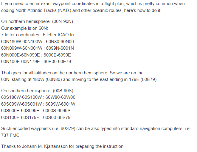
DCT AMAKR DCT LINUZ DCT NATTE DCT 44N130W 48N140W 50N150W/N0496F320 52N160W 53N170W 52N180E 51N170E/N0494F340 DCT OMOTO R580 OPULO/N0491F350 R580 OATIS/N0499F360 Y802 LIGNI Y84 BUBDO A590 GURAG/N0494F380 A590 JOM/N0497F360 M767 TOKON/N0491F390 M767 TOMAN KART1A

I tried like 7 formats for the coordinates, all of which came out with “NOT IN DATABASE” How do I enter these into the FMS?

I forget where I found this or if it’s still accurate, but try this:
LATLOG

Are you flying with the Salty 747 mod? You might need that as well because I don’t know if this procedure works on the stock 747 or not.

1 Like

I’m not flying with the salty 747 mod, but also, I don’t exactly understand that format. How would I put 44N 130W in that format?

44N30 is my suggestion.

Ok I’ll try that

NO WAY GUH IT WORKED

2 Likes

Defo get the salty mod. It uses the same format for lat-long coordinate entry as the WT CJ4 FMC so you can copy that. Uploading a flight plan from simbrief will not load the oceanics. But you might get the entry and exit waypoints