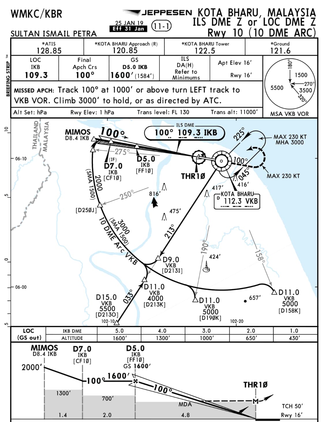
Hi guys, I’m confused about interpreting this ILS chart. There seems to be 3 boxes, 2 of which have different ILS frequencies 108.7 and 330.5. I understand the latter one relates to the Glide Slope/Path, but how do you tune such frequency? —I could only tune navaid frequencies of values 1xx only (ie. a value beginning with 1). And doesn’t one ILS frequency (eg. IKE in this case) contain both LOC and GS combined together?
I tried landing here but I got into quite a muddle and had to disengage AP when the approach did not seem to be progressing on cue.
Would appreciate some help as to how such plate is used in the AP. I was flying the TBM 930. Also, my flight plan was planned from world map which did not offer an ILS landing option, so my approach in World Map was selected to ‘Automatic’. TIA.
The only ILS frequency needed is 108.7. The other is for military and not usable by civilian aircraft. The VOR frequency is needed because the approach starts at 10 DME from VKP VOR. In other words, coming from any direction tune VKP first and fly in a 10 DME circle until the localizer/ILS is intercepted. The VOR transmits in all directions. The ILS/LOC is a focused radio beam transmitting in one direction only.
The TBM 930 is a very fast aircraft not very suitable for instrument training. You might want to try something slower like the C172.
With the introduction of Military aircraft into MSFS (and Top Gun Expansion one day), MSFS should evolve to be able to handle these UHF frequencies for Miltiary aircraft (or has it done so already ?)
Just one thing for clarification, The LOC & GS frequencies are normally paired, so when you tune the ILS freq it automaticaly tunes the correct GS frequency in the GS receiver or in modern aircraft the multi mode receiver (MMR). Thats why there is no GS tunning facility.
I had a look at the actual Malaysian AIP entry. The VKB is the VOR DME situated east of the aerodrome and is what you should use to approach the aerodrome, fly through and then fly an arc at 10 DME. The IKB is the ILS which you will intercept near a radial of 295. You then fly the ILS with the limitations of not below the altitudes underlined until 7 and 5 DME. It means you will I think be 100feet high at 5 DME for obstacle clearance.
May I ask about the source of this charts? Maybe this answer some questions …
In both screenshots we don’t see any information about the provider, nor any date of plate currentness.
In general the localizer is an VHF component (range 108.10 - 111.95 Mhz) and the glideslope a UHF (range 329.3 - 335.0 Mhz), therefore the different frequencies, military and civil …
Both frequencies are paired (localizer and glideslope) and will be automatically tuned to the localizer frequency by the navigation radios in the aircrafts. So, only the localizer frequency is important … Military works with channel frequencies (X/Y) but its the same principle …
Here a list of the pairing frequencies to make it more clearer (hopefully):
Many thanks for that explanation, Richard. It’s most helpful! Learnt something new!
With regards to your question:
The charts were lifted from the Civil Aviation Authority of Malaysia official site — aip.caam.gov.my and appear to be current (effective date 02 Dec 2021).
If I was setting up to fly the approach, all the info is there but not in one place. The LOC (ILS) freq is in one red box & the ident is in another but they are both there. Not a real good way of showing it. The distance references are right as the VOR is not located at the runway threshold as someone above stated. If you look at the navigraph approach plate for this rwy, it is a clear presentation of the approach.
Absolutely correct - the DME part is in this case a part of the glideslope (I guess therefore the reference on this chart to the ident IKB in the GS/DME box) and not a part of the localizer. The glideslope is sitting near the threshold - the localizer on the opposite site on the extended centerline of the runway (for ILS approaches). The VKB VOR is “only” needed for the DME-Arc (and of course for the holding) because all other references to IKB (= glideslope part).
But I´m also with you - this chart example is not the best to learn “how you can read a chart correctly” …
I just checked the Malaysian AIP and the IKB is 109.3 Mhz. It looks like this is a localiser only approach so you use the IKB for line up and the VKB for range and therefore heights. Not below 1600 at 5 miles and then 1200’ at 4 miles 900’ at 3 etc
No, it’s both … you can fly it as ILS or LOC only … the LOC only is a kind of “downgrade” of the ILS approach in case of “out of service” glideslope but for that you need the VKB VORDME navaid, that´s correct.
My bad it should have read
If I was setting up to fly the approach, all the info is there but not in one place. The LOC (ILS) freq is in one red box & the ident is in another but they are both there. Not a real good way of showing it. The distance references are ILS distance as the VOR is not located at the runway threshold as someone above stated. If you look at the navigraph approach plate for this rwy, it is a clear presentation of the approach.
All very good questions, may Insuggest if you are really interested to read a PPL theory book. When I was 14 years old I had MS95 flightsim and a theory book. I used the sim to learn to fly and now I am an airline pilot. Of course the sim didn’t get me my licence but I never needed an extra lesson and passed all the exams with high scores and went from zero to commercial-Instrument-multi engine in 19 months only. Good luck!


 . Thanks much in advance!