I don’t think it’ll ever feel realistic no matter what they do. I think it looks kind of realistic, based on how the turbulence chucks the aircraft about a lot more realistically after WU6. But it’ll never feel realistic because turbulence is felt, not watched lol.
Sorry to say. Not even remotely close. And of course one can never perfectly model turbulence. However other flight sims, much older and less advanced ones, have already proven that one can do a much much better job than MSFS currently does.
If you are genuinely interested take a look here.
… and then look ca 3days later when Perry flew the same approach in the sim having set the same wind conditions. Or try for yourself and see if you have to work as much as the two pilots in that Cessna.
I get the impression from Asobos initial video demo on wind / weather that they have a much more advanced system as the one they currently show. They also stated (see other posts) that they tuned down the current model and even continue to work on it for a re-release. So we will see.
3 Likes
Hi,
The numbers are temperatures and are below 0C unless + or PS (positive) is shown before the number.
For wind speed, half a stroke is 5 kts, a whole stroke is 10 kts and a little triangle or “flag” is 50 kts. Add it all up to find the windspeed.
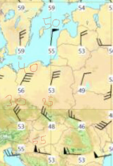
4 Likes
Thank you so much for the great explanation!
I’m having a hard time grasping what you are describing. What were the conditions when you saw this?
Were you using live weather?
Were you at high altitude or low altitude? Flying slow, closer to stall speed like on an approach? Or zipping along?
What aircraft were you flying, a heavy or a light GA aircraft? Is it a really hot locale or more on the cool side, temperature wise?
Serious question. Honestly, I’m trying to figure out where you would’ve experienced that with the Sim in its current state.
Thanks!
All these people are pointing you to the wrong places (real life aviation weather, real life maps etc) The real life places are real, but not necessarily what you get on live weather for the sim. Remember they rely on a world wide model for aviation weather. where you need to go to get that information is at the source of MSFS weather: Meteoblue.
Look for the area you will fly
Click on weather maps on the left
Click on Aviation and clouds on the right
Look for the option "clear air turbulence (CAT)
Set the altitude you will be flying (Altitude on Mb pressure, let me know if you need a conversion table)
Voila! This is the ACTUAL REAL WEATHER MSFS weather model. You can use that to plan your flight.
2 Likes
MSFS uses Meteoblue to inject precipitation and clouds only. Winds, atmospheric pressure and temperatures (at the ground) are injected via METARs.
MSFS weather engine does NOT inject turbulence prediction data. At least for now. Who knows what exactly is planned next year for their new weather engine.
5 Likes
Weather outside of a certain radius from the METAR reporting airport also comes from the Meteoblue model, which is most places. So pretty much all of the turbulence you’ll see in the sim is terrain induced from forecast model based winds. Check Meteoblue’s surface winds over mountainous areas to guesstimate where the sim will be bumpy.
2 Likes
This is an awesome information thank you so much I really appreciate it ! ![]()
Yeah I think I’m gonna need one, with a quick googleing I found something I don’t think my calculations are correct ![]()
200 MB 38662 ft 11787 m is this correct?
Yes correct (for ISA conditions)
1 Like
Thank you so much !
This is a good point. Do you have a source on this? I am trying to build an algorithm for weather forecasting within MSFS. Meteoblue already displays METARs and TAFs so in theory, you can consider them part of the MSFS weather model and you wont need to look anywhere else.
Sounds about right. I use this table. Easy and fast to look at
1 Like

And it’s pretty easy to check in the sim. Like @SkipTalbot corrected me - Meteoblue injects precip and clouds.. winds, temps and atmospheric pressure comes from METAR reporting stations. However, as you fly away from the stations, the Meteoblue model takes over the winds, temps and pressure as well.
So it’s a combo of real-life reporting weather stations and a numerical weather forecast.
I think it’s a good approach, there are limitations however. Since the numerical model doesn’t have an “ultra-good” resolution, some weather phenomena get lost - for example fogs. They are very hard to predict and usually only high-resolution weather models can see them. And even then it largely depends on microclimate conditions - any cloudiness will halt radiative cooling, any water body will help to form a fog.. etc.
Martial from Asobo said they are working on a new approach. Taking the METARs, injecting them into Meteoblue and then into the sim’s weather engine. We then should see the weather get much more precise, especially in cloudiness I think.
Sorry for the OT. To reiterate - mechanical turbulence in the sim is generated by aerodynamical simulations, not injected by a numerical weather forecast model. If you have stronger winds, the winds will flow over mountains and objects and generate turbulence.
Maybe it’s off topic but, the current version of the game does not support fog right ? I remember one day I was flying to KLAX and the METAR showed that the weather was foggy, but during the landing there was only one cloud and it was at 10000ft. or something ![]()
I think it does support fog, I’ve seen some fogs at KLAX and at Vandenberg AFB, once even at an airport in Germany I can’t remember now.
However the fogs are shallow and still have plenty of visibility in them. It’s not rare to have a fog with 100 meters visibility/RVR, the sim can’t reproduce that at the moment.
And like you said - when you’re at the airport, the sim only takes winds, temps and pressure from the METAR. It doesn’t take into account clouds, visibility, humidity/dew point temps etc.
The problem is that not all METARs report all cloud bases. In the Czech Republic, we don’t report clouds above 5k feet. Only automated weather stations or airforce stations do. Imagine you have a weather engine that injects clouds depending on the METAR. You’ll have an airport with OVC051 in the METAR and the sim will reproduce that - the sky will be overcast with stratocumulus clouds at 5100 feet. 20 km away you have a manned civil airport with the exact same clouds: OVC051, however they won’t report that because it’s of no use to aviation. The METAR will then report CAVOK and the sim will have an absolutely clear sky, even if it’s overcast IRL.
Asobo elected to go the way of numerical weather prediction - but it’s just that, a weather prediction. They tend to be wrong sometimes and there’s nothing we can do about that. That’s why the weather in the sim is oftentimes wrong and sometimes bang on.
I’d really like to see those crazy autumn/wintertime fogs in the sim as well. I hate them at the airport I work at, because their behaviour is hard to predict, but it’s amazing how the whole airport wakes into action when low visibility procedures are in force. I sit in the weather station, METAR reports 100 meters visibility, I can hear the landing traffic, but I can’t see a ■■■■ thing.
1 Like
This topic was automatically closed 30 days after the last reply. New replies are no longer allowed.