How to rolling from runway to gates without blue ribbon in large airport?
Hi,
IRL the pilots us charts to find their way to the gate.
Should you become completely lost, you can ask the ground controller (or the tower, if there is no ground control) for “Progressive taxi instructions “.
The controller will advise you when to take a turn and guide you to the gate.
Hope this helps.
5 Likes
It’s not for free but I strongly recommend Navigraph!
If it’s because you find the standard ribbon too intrusive (which it is), try subtle taxi ribbon from flightsim.to.
It also removes the huge parking box. Now discontinued, but it’s still on the site; it’s been replaced by an animated ribbon, but it doesn’t remove the parking box, so till it’s updated you have to use both if you want the animated one.
If all this is unclear, all the info is on the site.
1 Like
I’m retired and I don’t want to pay everywhere, but thanks for the advice.
3 Likes
Try LittleNavMap. I pause before taxiing to the runway and zoom in on my location. From there, I follow the ATC taxi instructions by locating the taxiways and following them on LNM. Works almost every time. I also pause after exiting the runway following landing, then do the same with ATC ground instructions to Parking. IRL, you’d have already studied the charts and had a reasonable idea where you are and where the taxiways are ![]()
4 Likes
Google ‘Free Airport Diagrams’, there are quite a few. The airport diagram will show taxiways, runways, and other general areas/info for your dep./dest. This is the ‘old school’ method and does required a bit of interpreting your position and visualizing (i.e. thinking ![]() ) about how to get where you want to go.
) about how to get where you want to go.
There are also the same type of charts for Gate and Parking locations as well (at larger airports).

As mentioned Little Nav Map is great because (one, it’s free) and two, it will show your position in relation to the airport as you taxi/fly.
2 Likes
+1 for LittleNavMap. Its free and is stuffed full of features. A great moving map while you fly and when you are on the airport just zoom in.

4 Likes
Most pilots familiarize themselves with the airport layout before getting in an aircraft or landing there.
2 Likes
AirNav and Skyvector for up to date FREE charts for the U.S.A FlightPLN for Canada. But DO NOT file a flight plan. As it is a data base of charts for real world use. And ChartFox is a compilation of charts From VATSIM users where you can find a lot of free charts for the uk.Italy Germany Spain and a few others. Find the gate on the Areodrome layout of the airport and plan accordingly in your pre flight. ![]()
2 Likes
I have a question, can I see my plane on skyvector? And how do I connect my msfs2020 account to it, because I play on Xbox one s that is connected to a tv…
You can try to use this: MSFS 2020 SkyVector Moving Map » Microsoft Flight Simulator.
I use it also, but I am on PC.
I used to try to follow ATC instructions from Airport Diagrams, i.e., KDEN or other big airports. It can be done but looking at the diagram, figuring out my initial position and then interpreting ATC taxi instructions was a real pain. As mentioned, IRL, you should have a pretty good idea where you need to go, but hey! Its a simulator. LNM solves the hassle, I know where I’m at, I can zoom to the taxiways and quickly determine my path to the runway. Easy and cheap. 
2 Likes
okay will do that.
Hey, don’t get me wrong. I do the same thing, just tend to use Navigraph vs. LNM.
Navi. does the same thing. It will show your position on the actual Airport Diagram chart and follow it along as you taxi. The downside is, it is subscription based whereas LNM is free as you noted.
Both are good tools to have.
2 Likes
Yup. No offense taken, I’m just not willing to spend $10 a month on a subscription that I’m unsure of the value. Sounds like MS Officeproducts BS… I’m flying a simulator, LNM works fine for my purposes. If my life were on the line IRL, I’d have the most current and valuable info available to me. But, I crash occasionally… ![]()
2 Likes
There are various places you can get charts for free. Simbrief has most if not all US airports and all the charts associated with them for free. I keep airport map of every place I am flying out of or into at hand printed out so I can use them to find way on ground. I do have taxi ribbon enabled and find it helpful. Half of the time, cannot get Flight Plan made in Navigraph to open up in MSFS by importing it, so just ignore or turn off ATC but sometimes I want to see if it works. Hit or miss lots of the time. Happy flying.
2 Likes
I do the same. By using LNM you are doing what they do IRL ![]()
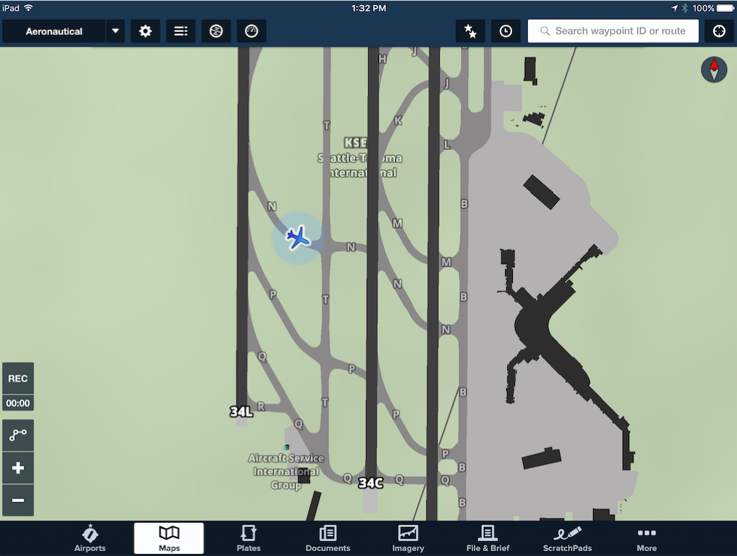
Many GA pilots use the app ForeFlight on a tablet which can show airport diagrams.
Airline pilots also use tablets and the newer airplanes show the airport diagram on the airplanes own display.
Boeing 787 map video clip:
Boeing 787:

ForeFlight on an iPad: