Is there a way to identify towns you’re flying over?
Thanks.
Currently in the sim, no. There are plenty of external applications that couple with MSFS and show your plane over an openstreetmaps / google maps chart.
My favourite is LittleNavMap, but that is a fairly substantial app with loads more functionality (including flight planning, logbooks etc). There are simpler apps as well.
If you have glass cockpit with G3000 moded… you can.
VFR sectional map, and use pilotage (takes a lot of practice).
I find VFRmap a useful little tool, though I’ve yet to try LittleNavMap which I have also downloaded
Sure. Fly low and read the name off their water tower !
been there… done that!
What if they dont have one? LOL.
Fly the TBM with the G3000 mod and town names appear on the map. A brilliant feature.
No quite the same topic, but can anyone tell me, if there is a program which saves GPX track of a flight in MSFS just like in real life? So I can later see it in Google Earth for example…
Tacview is able to record and later show data out of various real life equipment, and flight simulators. There’s a free version, as well as a payware version. After first install, you get a 30-day trial of the full paid version, but after that, you can continue to use the free version indefinitely, albeit without some of the functionalities.
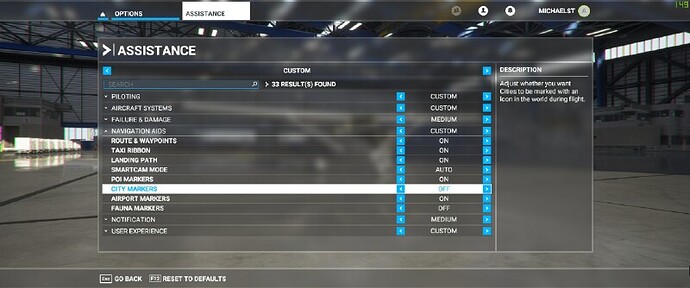
I don’t know if it reveals the name because I’ve never had it on, but there is a way to identify cities.
Options/Assistance/Navigational Aids
I have it turned on but get no city names. It does not work.
