If a STAR is listed as RNAV, can it be used as an ILS route or is it RNAV only?
An ILS is an approach to the airport, a STAR is a departure from the airport.
But whatever the chart says is what system is used. An RNAV departure uses GPS, an RNAV approach uses GPS, and only GPS.
Sorry but that´s completely wrong a STAR is an arrival route TO an airport
SID = Standard Instrument Departure Route
STAR = Standard Arrival Route
IAP = Instrument Approach Procedure
A traditional ILS approach uses a ground based ILS system comprising of a localizer for course guidance and a glide slope for vertical guidance. It can go down minimums as low as 200 feet off the ground and 1/2 mile (2400/1800 RVR). It can even be certified lower for autolandings with minimums down to 0.
A RNAV approach uses Random Nav for approaches. It can be a self contained system using auto-tuning navaids, or using GPS. RNAV (RNP) approaches can get down to around Cat 1 ILS minimums and 0.1 of a NM tolerance (RNP). RNAV GPS approaches using WAAS can get down to ILS minimums.
So, they are two entirely different systems.
Hope that helps,
Richard
3 Likes
A STAR gets you in the vicinity of the airport. An approach gets you to a runway. To directly answer your question, yes, and RNAV STAR can end in an ILS approach.
Sorry, hadn’t had my coffee yet. And I’m an instrument rated pilot! ![]()
1 Like
Oh ![]() … then “drink and fly”
… then “drink and fly” ![]() …
…
Have a nice day and happy flying,
Richard
1 Like
And now that I have had my coffee, it will usually state on the STAR chart which approach to expect. So if you want a particular approach, it’s worth checking the STAR chart to see if it is one of the approaches that you can expect. Remember that your STAR and your approach have to match up.
Respectfully, I need to disagree with that. Maybe it’s different in different countries, but in the US at least, STARs provide an orderly flow into the vicinity of the airport. I don’t recall any that are tied to a particular approach procedure, but they often have different legs depending on the runway in use.
Check the Jepp charts, not sure if it’s stated on gubmint charts or not.
I use Navigraph charts which are the Jeppesen charts. I’d be curious to see one that actually specified the approach procedure.
1 Like
MPTO. AKRIN, BUSUN1, VALIS and OSUPA 1A arrivals all specify an approach to execute. In the US you’ll often see “expect radar vectors to the final approach course”, internationally you’ll often see “expect ILS RWY 21” or simply “execute RNAV RWY 3 approach”. You should always check in any event. It’s one reason why I never fly the STAR into TNCM, I prefer the RNAV over the VOR approach.
1 Like
The other consideration is weather. I always want the approach with the lowest minimums, which is usually an ILS or an RNAV. At really busy airports like JFK, BOS, etc. you’re always going to see “expect radar vectors”, they absolutely have to do that for traffic separation. At more out of the way airports they may give you an arrival (and it might be the only one) that gives you an approach with the highest minimums. Depending on the weather that can be the difference between getting in and going missed.
Doesn’t it stand for Radio Navigation? Why would navigation be random?
1 Like
No. It stands for Area Navigation.
 … LOL, thanks to the auto-correcter on my mobile phone
It´s not random, of course … it´s Area as Michael(@anon17491698 ) wrote … @anon17491698 possible I also need a cup of coffee
1 Like
Never seen that in Europe either, I have used both Jeppesen and Navblue in real life.
If it’s one thing I do find a little hard to work out or do and that is finding a star that connects up to a ILS and have always wondered that same question…
My observations is (Navigraph) you either have a continuous line from STARS to approach or a direct dotted line if you select another approach you want to do that doesn’t match up…
In Navigraph…
If I can only get that continuous line connection for a RNAV approach to link up with the STAR, and not a ILS, can I dial in the radio for the ILS and do it anyway… Or follow that direct dotted line to the start of the ILS. Or is that when we depart from reality and real life flying and arrive into the world of arcade mode without knowing…
Example and a slight annoyance is simbrief and not being able to have a continuous flow or being able to select all approaches…
You guys will have many examples
Airways that I get given on simbrief don’t often connect up with waypoints for a ILS on navigraph nor are there any options to have a route to connect with a ILS STAR…
I either have to delete a few waypoints or just simply break from reality and do a fake direct to either a fake direct to ILS or do the RNav and tune in on ils
Most flights to Glasgow ends up with a dotted line from STARS to ILS apporach I find.
Auckland to Sydney is another example… If you want a ILS for 16LR you get that approach going over Sydney and up the ILS approach line which often breaks the autopilot when doing the return u turn… when on FR24 they often go north up the coast parallel to the ILS then connect to the ILS…
Flights from Auckland to LAX is another example, I can only get RNAV options for the southern runways from simbrief whereas in real life observations… The likes of Air NZ hook up to the STARS for flights coming in from north of LAX going over those islands but I can’t seem to get those options from simbrief and have to manually edit them in Navigraph (Can completely understand why newbies get real confused when things don’t match up to flights they are trying to emulate or unable to get a ILS approach on Navigraph because the only star options on simbrief only link up with rnavs…)
You have to remember that sometimes a STAR ends with a vector approach to the final approach fix. This means ATC tells you where to go. The game doesn’t have that so you have to vector yourself in those situations.
Copied this from another thread, maybe it answers some questions? Don’t know what dotted line we are talking about, I assume vectors?
The first thing to understand is that the arrival / approach to an airport is split into segments:
- Arrival
- Initial Approach
- Intermediate Approach
- Final Approach
- Missed Approach (which itself is split into the same phases above minus arrival)
Each of those phases serve a purpose in maneuvering, slowing down and configuring the aircraft for approach.
Arrival
The Arrival segment starts from where the en-route segment (airway) is left and ends at the Initial Approach Fix (IAF). This segment is used to slow down the aircraft and descent for approach, it often ends in a holding pattern over the IAF.
Initial
The initial approach starts at the IAF and ends at the Intermediate Fix (IF) the IF is located on the extended centerline (point of localizer intercept) usually a few miles (minimum 2 nm) prior glideslope intercept or start of descent on non-precision approach.
Intermediate
Intermediate approach is the usually straight segment between the IF and the FAP - Final Approach Point (Precision or APV approach) or FAF - Final Approach Fix (non-precision approach).
Final
The final approach starts at the FAF or FAP and ends at the Missed Approach Point (MAPt). The MAPt is usually the point where the glidepath intercepts the Decision Altitude. The approach is then either continued to a landing if sufficient visual references are attained or a missed-approach is executed if not.
Where can you find each of those phases?
En-route Segment
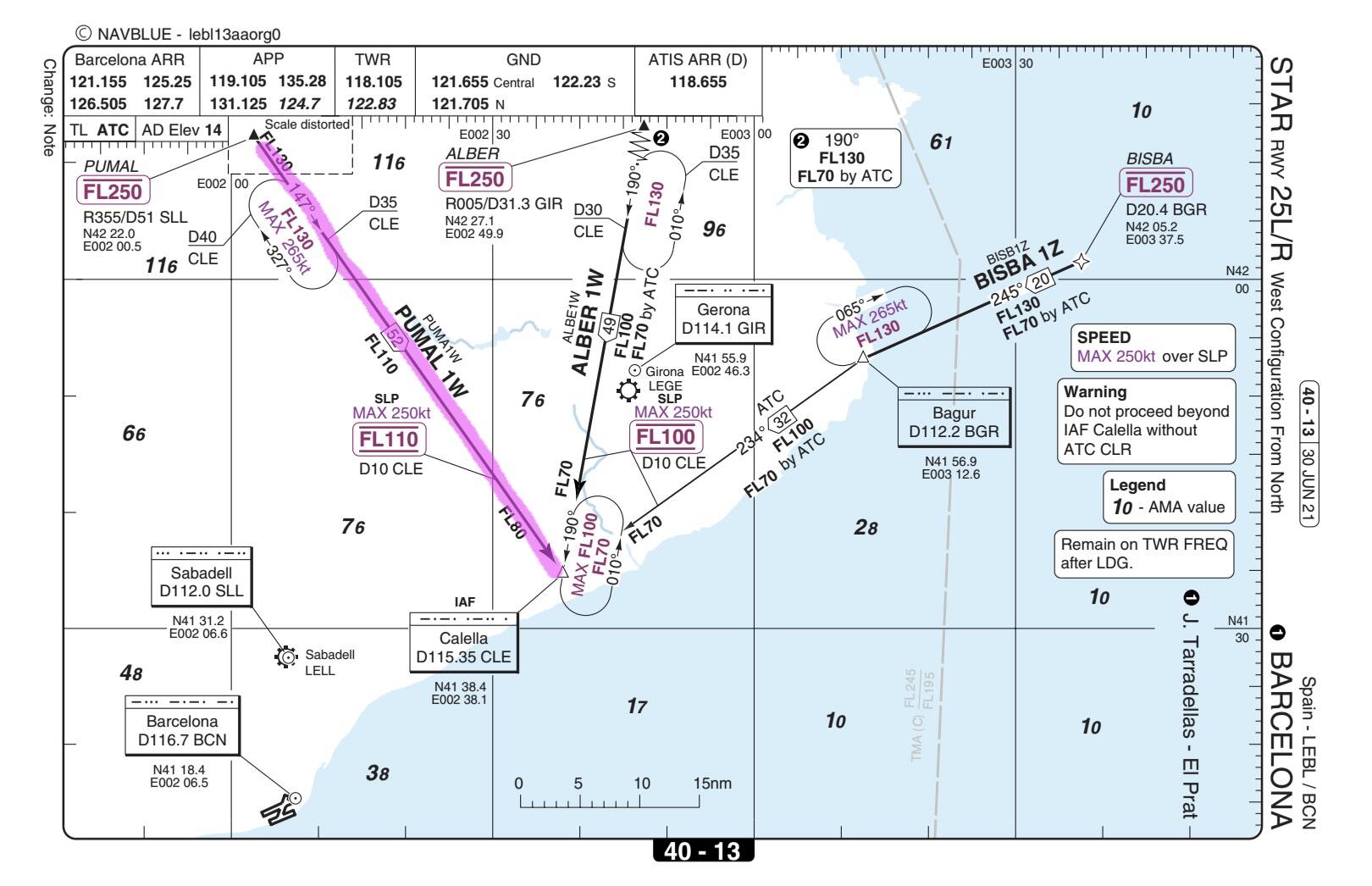
If you open Skyvector you can see the point PUMAL I’m using in the example below, is the point where you leave the en-route (airway) system. This is where the Standard Instrument Arrival (STAR) starts.

Arrival Chart
The Arrival segment, commonly referred to as Standard Instrument Arrival (STAR) can be found on the arrival chart, I’ve included an example below:
Transition
The initial approach can be on a separate chart called a “Transition”. The “transition” refers to the transition from the IAF and the IF. On some approaches and on smaller airports there isn’t a transition and the initial approach segment is depicted on the instrument approach chart.
Below you can see a transition to the ILS 25R via the North. It looks like a snake, usually you’ll receive vectors or receive shortcuts from one end to the other, you rarely fly the whole transition. For example if its really quiet you can expect to fly from CLE direct TEBLA, shortcutting the whole transition (from IAF direct to IF) or receive similar vectors.

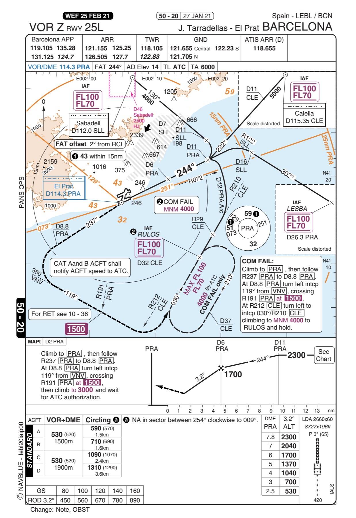
Approach Chart
Intermediate, final and missed approach are depicted on the instrument approach chart and in some cases the initial approach as well as discussed above:
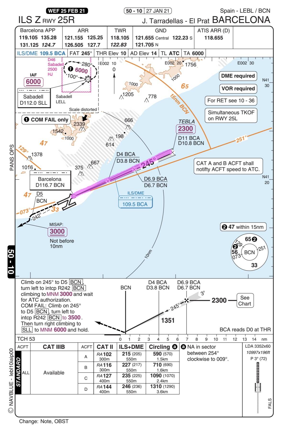
If you now compare this chart with the VOR approach you will notice that the ILS approach chart starts at the IF, so the intermediate, final and missed approach are on the approach plate. The VOR approach plate starts at the IAF so in addition to the intermediate, final and missed approach segments the Initial approach is also depicted (no complex transition on a separate chart).
I think FS2020 automatically selects the whole transition which makes the arrival look like a long snake. If there is a arrival not connecting to the final approach axis (e.g. vectors), the sim creates this long arcs to connect the two. I think the sim currently is unable to deal with discontinuities.
1 Like