Edit: Added areas covered
If you do not have a source for Charts, check this neat site.
You can view the Chart and also download it .
Examples:
https://www.airnav.com/airport
(https://www.airnav.com/airport/ewr) (KEWR)
AirNav: KEWR - Newark Liberty International Airport (Newark, NJ Airport - KEWR)
VORs
Nearby radio navigation aids
VOR radial/
distance VOR name Freq Var
TEBr218/10.5 TETERBORO VOR/DME 108.40 11W
CRIr302/13.4 CANARSIE VOR/DME 112.30 11W
LGAr260/14.7 LA GUARDIA VOR/DME 113.10 12W
JFKr293/18.4 KENNEDY VOR/DME 115.90 12W
COLr010/22.9 COLTS NECK VOR/DME 115.40 11W
SBJr086/26.9 SOLBERG VOR/DME 112.90 10W
SAXr154/28.1 SPARTA VORTAC 115.70 11W
BWZr113/30.4 BROADWAY VOR/DME 114.20 11W
RBVr037/33.0 ROBBINSVILLE VORTAC 113.80 10W
STWr131/36.6 STILLWATER VOR/DME 109.60 11W
DPKr273/39.8 DEER PARK VOR/DME 117.70 12W
RUNWAYS
Instrument Procedures
NOTE: All procedures below are presented as PDF files.
If you need a reader for these files, you should
download the free Adobe Reader.
NOT FOR NAVIGATION. Please procure official charts for
flight.
FAA instrument procedures published for use from
30 November 2023 at 0901Z to 28 December 2023 at 0900z.
STARs - Standard Terminal Arrivals
BRAND ONE (RNAV) download (231KB)
FLOSI FOUR (RNAV) download (254KB)
PENNS TWO CHANGED download (160KB)
PHLBO FOUR (RNAV) 2 pages: [1] [2] (386KB)
SHAFF SEVEN CHANGED 2 pages: [1] [2] (412KB)
WILLIAMSPORT THREE CHANGED download (180KB)
IAPs - Instrument Approach Procedures
ILS OR LOC RWY 04R download (346KB)
ILS OR LOC RWY 11 download (316KB)
ILS OR LOC RWY 22L download (354KB)
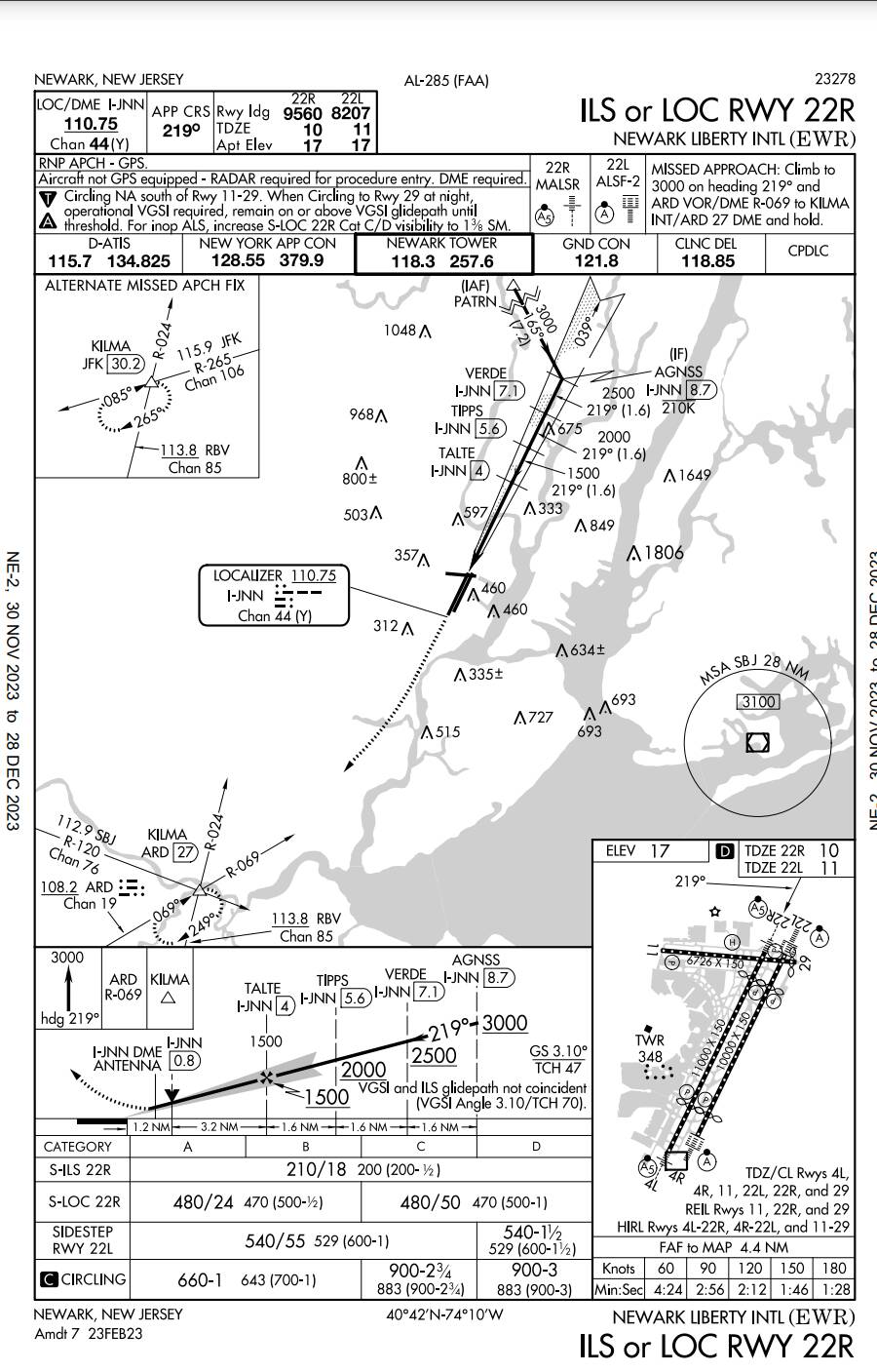
ILS OR LOC RWY 22R download (343KB)
ILS Z OR LOC Z RWY 04L download (330KB)
ILS RWY 22L (SA CAT I) download (316KB)
ILS Z RWY 04L (SA CAT I - II) download (311KB)
ILS RWY 04R (CAT II - III) download (289KB)
ILS RWY 22L (CAT II - III) download (325KB)
GLS RWY 04L download (255KB)
GLS RWY 04R download (256KB)
GLS RWY 11 download (238KB)
GLS RWY 22L download (236KB)
GLS RWY 22R download (235KB)
RNAV (RNP) Y RWY 22L download (236KB)
RNAV (RNP) Y RWY 29 download (260KB)
RNAV (RNP) Z RWY 04R download (282KB)
RNAV (RNP) Z RWY 29 download (287KB)
RNAV (GPS) RWY 04L download (301KB)
RNAV (GPS) RWY 11 download (267KB)
RNAV (GPS) RWY 22R download (281KB)
RNAV (GPS) X RWY 29 download (274KB)
RNAV (GPS) Y RWY 04R download (285KB)
RNAV (GPS) Z RWY 22L download (277KB)
COPTER ILS Y OR LOC Y RWY 04L download (264KB)
COPTER ILS/DME RWY 22L download (258KB)
BRIDGE VISUAL RWY 29 download (196KB)
STADIUM VISUAL RWY 29 download (285KB)
NOTE: Special Alternate Minimums apply download (143KB)
Departure Procedures
DEVIL ONE NEW 2 pages: [1] [2] (374KB)
LIBERTY FIVE 2 pages: [1] [2] (573KB)
NEWARK FIVE NEW 2 pages: [1] [2] (461KB)
NEWARK FIVE, CONT.2 NEW download (210KB)
CHART (example) (click download to display the PDF & print if wanted)
This is a screenshot of KEWR runway 22R that I downloaded.
Edit : Areas covered with number of charts each
American Samoa (3)
Anguilla (1)
B.V.I. (1)
Bahamas (26)
Bermuda (1)
Canada (82)
Carib. Netherlands (1)
Guam (1)
Marshall Islands (11)
Micronesia (5)
Northern Mariana Is (4)
Palau (3)
Puerto Rico (10)
Sint Maarten (1)
St Martin (1)
Turks & Caicos (4)
U.S.V.I. (2)
US Minor Islands (1)
USA (4727)