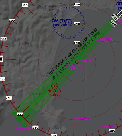
Sorry if this has already been requested but couldn’t find the request with a quick search. Anyway, would be really nice to have the ILS courses/headings visible on the in-sim map, preferably on the VFR map that you can view in-flight so you can view frequencies and courses on the fly as a runway is being assigned to you.
I’ve been trying to use the courses from websites like apxp.uber.space but it seems that even though the frequencies and identifiers match perfectly for every airport, the ILS courses often don’t and put me on a incorrect approach. So my guess would be that the course/heading isn’t the same as from the websites?
It’s no big issue really since landing manually is more fun anyway, but would be nice to be able to do proper ILS approaches at each and every airport that supports ILS.
I know its technically a “VFR” map, but it would be great if we could toggle on/off some extra map layers and things espcially extended centre lines and ILS approach cones/paths etc.
Unless this is possible somehow else? I know 3rd party programs like Little Navmap displays this, but that means using another monitor etc.
Back in the day I loved FS Navigator and using it in sim with the F9 toggle.
Oh, I didn’t know this. Then it must be the database, yeah. For me it was Denver INTL, KDEN, runway 26 that seemed to put me on a wrong course anyway. Made me approach too much from the right to the left. So basically flying at it with -10ish degrees.
There were other airports too but can’t remember which ones exactly.
Yeah, the websites seem to match the sim perfectly as far as I found out. All identifiers are correct anyway. Just seems that the courses are not always correct.
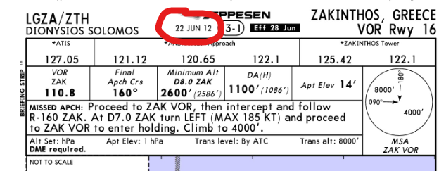
I wouldn’t really rely on charts like this. Frequencies may change, runway numbers may change, speed and altitude constraints may change. Basically everything on this chart might have changed since 2012 when it was obviously published.
Or a Navigraph subscription for around 10 bucks a month to get access to the latest Navigraph charts.
There’s also Little NavMap which provides lots of information (pulled from the sim directly, if I’m not wrong).
@dflight8685 be aware that charts from this sub-site aren’t meant to be used for navigation. From what I know these are just (outdated) example charts used to test and train the visual improvement of Jeppesen charts.
Sure, I didn’t say things have to change. I personally just feel better when I don’t have to hastly look up information mid-flight in case something surprisingly has changed.
Besides, you can basically get many many current charts for free. Just not the fancy Jeppesen ones, though.