I do wish Asobo and some airport developers as well would realise how important it is that the correct identifiers and frequencies are used for runway localisers. Another flight was ruined today because the map in the sim shows the ils info completely wrong for 22L, 22R, 04L and 04R at EKCH Copenhagen. And before anybody says there are thousands of airports, that’s an excuse not a reason to explain why a major international airport, a countries largest no less is so hopelessly incorrect in the flight planning map.
Moved to #self-service:airports
How is this remotely related to community help when the problem lies with Asobo’s code? Self service applies to things we have the power to change, not something that is in Asobos court!
2 Likes
It allows others to see if they can repro the defect, as Martial said on a recent Q&A, is one of the key steps to helping Dev Team figure out what to fix.
1 Like
Ok fair enough. They will need though to be aware that I am using a paid add-on from Fly Tampa that is correctly setup with the right frequencies.
if this post belongs somewhere it’s in the ‘BUG’ - aiports department.
here is a link : Airports - Microsoft Flight Simulator Forums …
1 Like
The trouble is we dont know what’s wrong, it it the default EKCH provided with the sim and the map looks there for information or is the map getting its ils frequencies from a master file, i,e a list somewhere?
The trouble is this problem keeps cropping up. ESSA supplied by Asobo and developed by Gaya as I understand it is also wrong, another major airport blunder in the same area more or less. What is in the sim may match the flight planning map but its not correct if you check the ils frequencies online.
checking for correct ils frequencies ‘online’ is a good way to start , BUT the online info might be outdated by many years depending where you checking for that info.
it would be nice of Asobo to display the correct info on the world map so you won’t have to check at other sources…
3 Likes
I may be wrong but I very much doubt if any airport in the real world is going to switch the ILS frequency and ident around on a runway, there just would not be any advantage in doing so, it just complicates matters and creates a lot of expense and chart issues for no gain whatsoever.
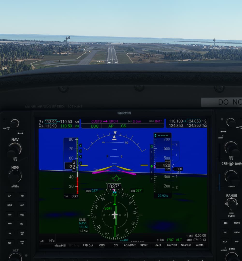
But this is what I keep finding in the sim, ils frequencies are right but at the wrong end of the runways so there I was approaching 04L at EKCH on 110.90 (KLK), the NXI G1000 switches to Loc1 and the arrow is pointing backwards and the glide slope is a dead loss.
I have checked the EKCH 04L ILS and I can´t reproduce it.
Here the approach with the NXI G1000 - you see the LOC arrow shows into the right direction, also the GS are nearly perfect.
I have tried the same with your ESSA example - the same, perfect approach … using Sim v1.24.5.0, standard stock sceneries and AIRAC 2203.
I assume more an issue on the user side and/or the user sim configuration, but I can´t really believe that this is an Asobo issue. Possible a few screenshots for your side can say more …
Cheers,
Richard
I suppose you could modify the airport so it has correct frequencies for the ILS and points in the right direction.
But why should you do that? As you see (at least with the stock scenery of the sim) the frequency is correct with 110.50, the direction also … He is using a 3rd party scenery so, this is more or less a scenery issue or a priority issue in his scenery file.
My recommendation in such cases is:
Remove the 3rd party scenery and try to fly the approach again (means only with the stock scenery, as I had done). Also, try it with a different aircraft to avoid here implementation issue …
Again, everyone is invited to test it - you need only a few minutes of time … I´m sure, the result is the same as in my screenshots.
Cheers,
Richard
Hi Richard.
You are correctly tuned to 110.50 CH approaching runway 04L so yes, Loc 1 is pointing in the right direction.
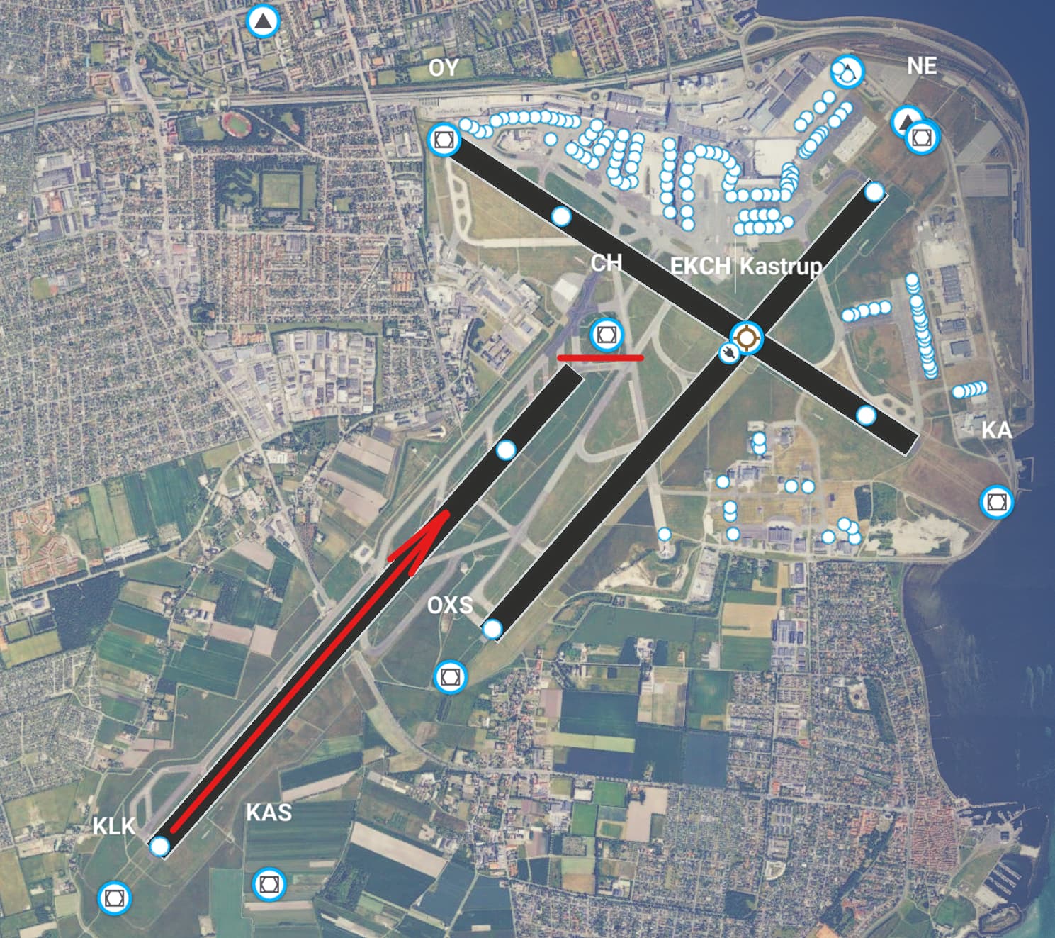
Go into the sims globe/map to create a flight and click the localiser on 04L and you will see the problem. Asobo have the localisers for 04L/22R and 04R/22L backwards which is why my CDI was pointing in the wrong direction.
I have edited my example to reflect the Asobo ILS settings, I had the correct Tampa frequency and ident in the post originally instead of what was actually used on my flight based on the sim data. Applologies for the confusion.
Hi again,
sorry, can´t follow you now … here what I see on the WorldMap:
The localizer is at the end of RW04L, what is correct so far. The localizer facility are ALWAYS (excluding offset-locs) at the end of the runway, means on the opposite site. The Glideslope and the DME not
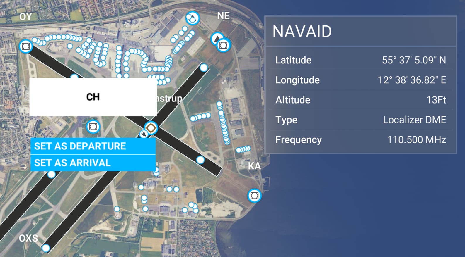
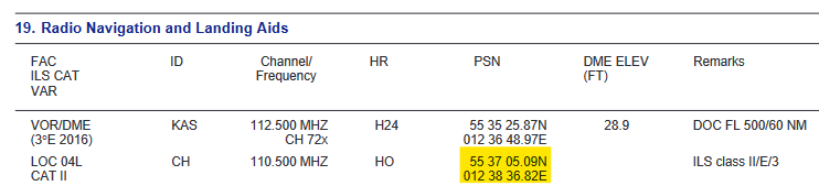
…here directly from the AIP Denmark - you see the coordinates for the ILS 04L (ident: CH) are exactly what you see on the WorldMap in the sim:
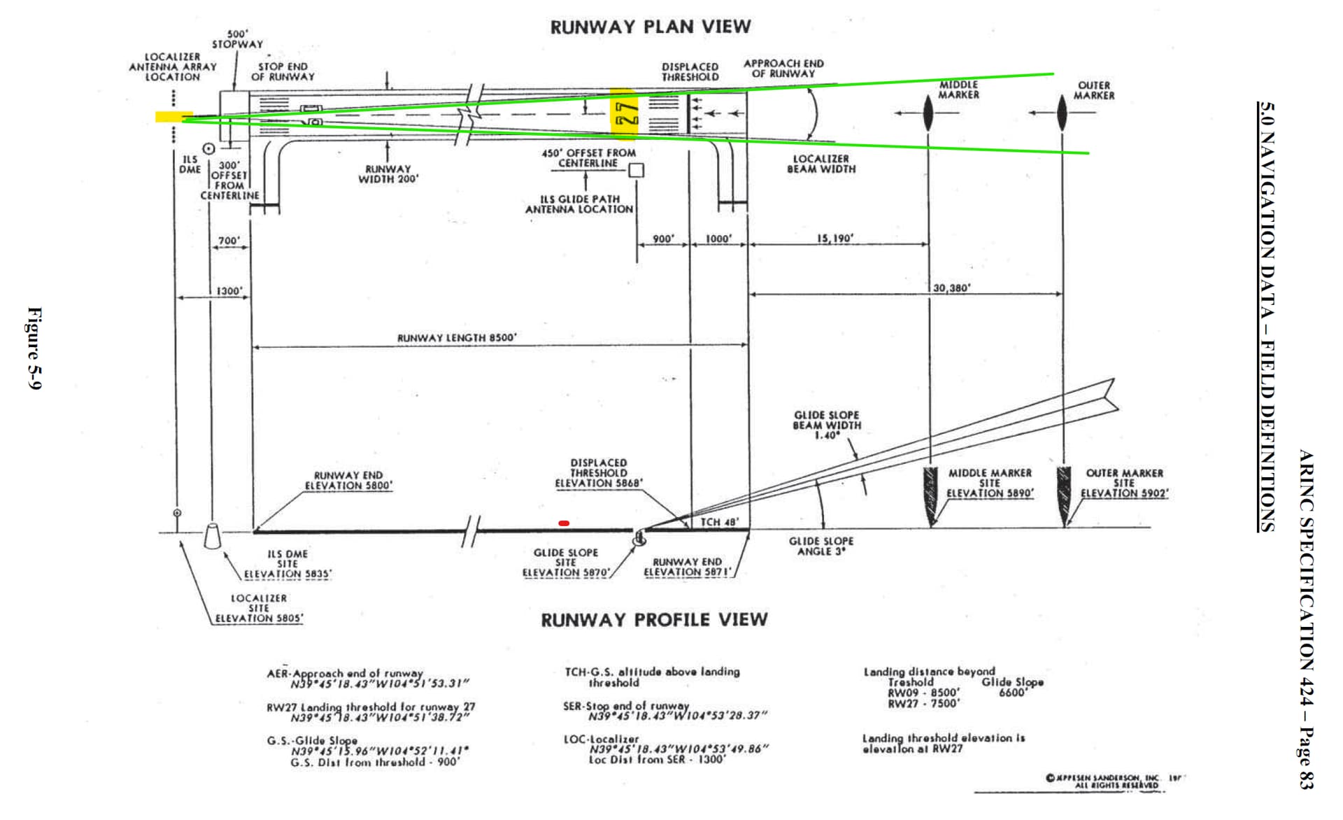
This is only a fictive example … you see the localizer antenna at the end of RW27 … the green lines are the signal of this antenna.
Possible you haven´t misunderstood the ILS and the position of each antenna?
Cheers,
Richard
1 Like
Wait… the world map has ILS frequency info ?
1 Like
I have some charts that are confusing in that case, they suggest that the antenna for a given runway are on the same end of the runway as the approach. No wonder I am confused, lol!
Thanks for the info Richard, much appreciated. I am obviously wrong making this whole thread redundant to a degree but at the very least I and maybe a few others have learnt something.
1 Like
You need to enable the navaids on the world map 
You´re welcome … no problem, one reason for the category change into the “Community Help Center” ![]()
Have a nice day,
Richard
1 Like
You too. Got to correct my ILS lists now, lol!
Hmmmm… I must be missing it. I have enabled NavAid but I dont see any info on ILS frequencies.