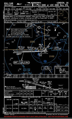
On FS2020, it says the 09L is 090 approach, but on uvairlines site (EGLL.pdf) it says 092. What on is right as I find the ILS is never lineup right. (Dreamliner)
Thanks for that. where can I get more charts like this?
In simple terms, as the ILS is a radio transmitter ground based system its lobes are pointed in a fixed direction. The aircraft equipment will sense wether it’s on the localiser or to the right or left of it and display that information to the pilot. This means it does not matter wether the published course is out of date due to the movement over the years of the magnetic variation, as the displayed localiser will guide you to that runway. Over many years runways will actually change their magnetic direction and the published number will change along with the painted numbers at each end.
In the specific case of Heathrow, the Jeppesen ILS 09 chart for September 1999 had the ILS on a localiser course of 093 degrees. The chart you referenced had it at 092 and the one posted by Athena has it at 089. In real terms you just need to tune to the localiser for runway 09 and you or your AP will track it to the runway. Many runways have a localiser that is offset to the runway direction so that you can actually be on the localiser but a few degrees angle of the physical centreline, normally this is planned for obstacle clearance considerations when the ILS was planned many years ago. At some time in the future the runway 09 at Heathrow will become runway 08 when the magnetic direction moves closer to 080 than 090 degrees. There’s a lot more to explain, but if you tune the localiser you can’t go wrong, in fact it’s irrelevant what you select as your course as the localiser (unlike a VOR) will still guide you to the runway.
You can get that chart from the Jeppesen subscription, but you can get them for free from the UK NATS AIP, just google heathrow airport charts and you’ll find them for all UK airports.
It’s from Navigraph, immensely valuable for any IFR flight planning in MSFS.
For the real charts updated regularly by the UK aviation authorities, bookmark this page:
http://www.nats-uk.ead-it.com/public/index.php.html
Click on eAIPPackage to open the current data in a new tab. On the left side of the new tab, click on “+AD 2 AERODROMES” under Part 3. Aerodromes are listed alphabetically by name, not ICAO, and Heathrow is listed as “London Heathrow.” When you click there, another sub-menu will open. The last option there is for all the charts. There’s no subscription and everything is free to download.
This topic was automatically closed 30 days after the last reply. New replies are no longer allowed.
